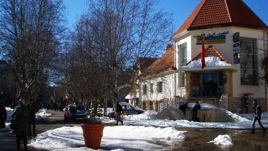
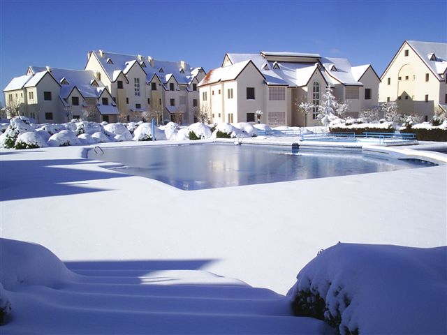
إفران

( Ifrane )

Ifrane (Arabic: إفران; Berber languages: ⵉⴼⵔⴰⵏ) is a city in the Middle Atlas region of northern Morocco (population 14,659 as of November 2014). The capital of Ifrane Province in the region of Fès-Meknès, Ifrane is located at an elevation of 1,665 m (5,463 ft). In the regional Tamazight language, "ifran" means caves.

The modern town of Ifrane was established by the French administration in 1928 during the protectorate era for their administration due to its Alpine climate. Ifrane was conceived as a "hill station" or colonial type of settlement. It is a resort town set high up in the mountains so that Europeans could find relief from the summer heat of the interior plains of Morocco. Ifrane is also a popular altitude training destination.

The first permanent settlement of the area dates to the 16th century, when the Sharif Sîdî 'Abd al-Salâm established his community in the Tizguit Valley, seven km downstream from the prese...Read more

Ifrane (Arabic: إفران; Berber languages: ⵉⴼⵔⴰⵏ) is a city in the Middle Atlas region of northern Morocco (population 14,659 as of November 2014). The capital of Ifrane Province in the region of Fès-Meknès, Ifrane is located at an elevation of 1,665 m (5,463 ft). In the regional Tamazight language, "ifran" means caves.

The modern town of Ifrane was established by the French administration in 1928 during the protectorate era for their administration due to its Alpine climate. Ifrane was conceived as a "hill station" or colonial type of settlement. It is a resort town set high up in the mountains so that Europeans could find relief from the summer heat of the interior plains of Morocco. Ifrane is also a popular altitude training destination.

The first permanent settlement of the area dates to the 16th century, when the Sharif Sîdî 'Abd al-Salâm established his community in the Tizguit Valley, seven km downstream from the present town. Ifrane is a colonial "hill station", and a "garden city". It is also an "imperial city", a mountain resort, a provincial administrative center, and a college town.

This section does not cite any sources. Please help improve this section by adding citations to reliable sources. Unsourced material may be challenged and removed. (January 2023) (Learn how and when to remove this template message)

The first permanent settlement of the area dates to the 16th century, when a sharîf by the name of Sîdî ‘Abd al-Salâm established his community in the Tizguit Valley, seven km downstream from the present town. In the Local Amazigh language, Ifran means "caves". Sîdî ‘Abd al-Salâm’s village, called Zaouiat Sidi Abdeslam (or simply the zâwiyah), consisted at first of cave dwellings hollowed out of the limestone valley wall. Only in the last fifty years or so have its inhabitants built houses aboveground. The caves which now lie under these houses are still used as mangers for animals and for storage.

By the mid-17th century Sîdî ‘Abd al-Salâm’s zâwiyah was well enough established to receive an extensive iqtâ’, or land grant, from the ‘Alâwî sultan Mûlây Rashîd b. Muhammad. The iqtâ’ extended from upstream of present Ifrane down the Tizguit valley all the way to El Hajeb escarpment. Late in the 19th century agro-pastoral groups of the Amazigh Senhadja Beni M’guild and Zenata the Ait Seghrouchen, crossing the Middle Atlas from the upper Moulouya Plain, started grazing their herds of sheep and goats on the surrounding plateau. The livelihood of the zâwiyah was based on irrigated agriculture on the valley floor, livestock grazing and forest resources.

The agricultural plots were held as private property (mulk) but the grazing land was under collective tribal jurisdiction (j’maa). The tribally organized populations of the Ifrane-Azrou area submitted to colonial rule after a period of resistance (1913–1917). Resistance continued higher in the mountains (Timahdit, Jebel Fazzaz) until 1922.

Modern history  Ifrane Al Akhawayn University

The modern town of Ifrane was established by the French administration in 1929 on land expropriated from the inhabitants of the zâwiya. The town was to be a "hill station", a cool place for colonial families to spend the hot summer months, and it was initially planned according to the "garden city" model of urban design then in vogue. The plan called for chalet-type summer homes in the Alpine style, laid out among gardens and curving tree-lined streets. A royal palace was also built for Sultan Muhammad b. Yûsuf. The town's first public buildings consisted of a post office and a church. Moreover, a penitentiary was built which served as a POW camp during World War II.

As elsewhere in Morocco, a shanty town called Timdiqîn soon grew up next to the colonial establishment. It housed the Moroccan population (maids, gardeners, etc.) that serviced the French vacationers. Timdiqîn was separated from the colonial garden city by a deep ravine. After independence, the French properties in the original garden city were slowly bought up by Moroccans. The town was enlarged and endowed with a mosque, a municipal market and public housing estates. Furthermore, the shanty neighborhood of Timdiqîn was rebuilt with proper civic amenities.

In 1979 Ifrane became the seat of the administrative province of the same name and some government services were established. In 1995 Al Akhawayn University, an English-language, American-curriculum public university opened and this has helped re-launch Ifrane as a desirable destination for domestic tourism. Consequently, Ifrane continues to develop as both a summer and winter resort. Old chalets in the center of town are being demolished and replaced with condominium complexes, while vacation centers and gated housing estates are springing up on the outskirts.

The Middle Atlas Mountains consist mostly of a series of limestone plateaux. Not far from Ifrane in the Middle Atlas is Cèdre Gouraud Forest. These plateaux receive considerable precipitation—averaging about 1,100/1,200 ml/year in Ifrane—and are naturally wooded, with scrub oak forests alternating with cedar. The Middle Atlas lies in the center of Morocco and constitutes its natural water tower, as many of the country's most important river systems: the Moulouya, the Sebou, the Bou Regreg, and the Oum Rabia originate in it. Historically, however, despite its centrality, the Middle Atlas has been an "empty quarter". Though the area was regularly crossed by traders, and though the alpine summer pasture was used by herders, the harsh climate and relatively poor soils long impeded permanent human settlement. Today the Middle Atlas is still one of the least densely populated parts of Morocco, even when compared to other mountainous regions such as the High Atlas and the Rif.

A small fort overlooking Oued Tizguit (now part of the palace precinct) had already been built during the period of military conquest in order to secure the Fez to Khenifra road across the mountains. The gently rolling landscape, with fresh springs and wildflowers, was judged to have potential as a summer resort for colon families from the Saïss Plain, Meknes and Fez. Fifty hectares of agricultural land upstream from the zâwiyah, in an area originally designated as Tourthit, or "garden", was expropriated for the project.

Ifrane was conceived as a "hill station" or colonial type of settlement. It is a resort town set high up in the mountains so that Europeans can find relief from the summer heat of tropical colonies. The British were the first to develop this type of resort in India, the best known of which is Simla in the Himalayas which served as their "summer capital". The French built similar hill stations in Indochina, such as Da Lat, established in 1921. Ifrane was not the only hill station to be built in Morocco. The French also built one in neighboring Imouzzer Marmoucha, as well as at Oukaïmeden in the High Atlas. Hill stations share some common characteristics. As they are intended for expatriate European families, and they are often designed in such a way as to remind their foreign inhabitants of their distant homelands. The architectural style adopted is imported from the mother country in order that the place look like "Little England" or "douce France". This is the case in Ifrane where various mountain styles such as "maison basque" "Jura" and "Savoy" were used. Moreover, trees and flowering plants were also imported from the European home country. This too was intended to heighten the appearance and feeling of home. In Ifrane, lilac trees, plane-trees (platanes), chestnut and horse-chestnut trees (marronniers and châtaigniers) and lime trees (tilleuls) were all imported for this purpose.

Photographies by:
nssaw tawahd - FAL
Statistics: Position
2545
Statistics: Rank
47987

Add new comment

Esta pregunta es para comprobar si usted es un visitante humano y prevenir envíos de spam automatizado.

Security
513294786Click/tap this sequence: 1192

Google street view

Where can you sleep near Ifrane ?

Booking.com
489.367 visits in total, 9.196 Points of interest, 404 Destinations, 5 visits today.