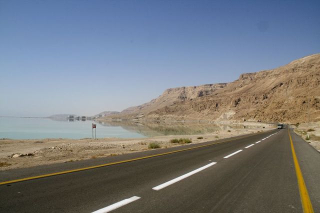
Highway 90 is the longest Israeli road, at about 480 kilometres (300 mi), and stretches from Metula and the northern border with Lebanon, along the western side of the Sea of Galilee, through the Jordan Valley, along the Dead Sea's western bank (making it the world's lowest road), through the Arava Valley, and until Eilat and the southern border with Egypt on the Red Sea. The central section of the road traverses the Israeli-occupied West Bank. While it passes near the city of Jericho, it runs through Area C and does not enter areas controlled by the Palestinian Authority.
The Arava Highway segment is the main link from the resort and port city of Eilat towards the country's centre and, at times, handles a heavy mix of local, tourist and commercial trucking traffic on the two-lane road (one lane in each direction). That, coupled with the monotonous nature of the desert landscape around it and the lack of a physical barrier between the opposing lanes of traffic, makes t...Read more
Highway 90 is the longest Israeli road, at about 480 kilometres (300 mi), and stretches from Metula and the northern border with Lebanon, along the western side of the Sea of Galilee, through the Jordan Valley, along the Dead Sea's western bank (making it the world's lowest road), through the Arava Valley, and until Eilat and the southern border with Egypt on the Red Sea. The central section of the road traverses the Israeli-occupied West Bank. While it passes near the city of Jericho, it runs through Area C and does not enter areas controlled by the Palestinian Authority.
The Arava Highway segment is the main link from the resort and port city of Eilat towards the country's centre and, at times, handles a heavy mix of local, tourist and commercial trucking traffic on the two-lane road (one lane in each direction). That, coupled with the monotonous nature of the desert landscape around it and the lack of a physical barrier between the opposing lanes of traffic, makes the road particularly prone to traffic accidents, which often occur at high speeds – earning it the nickname "The Red Road."


![[node:title]](/sites/default/files/styles/640x320/public/default_images/default_0.JPG.webp?itok=aqV9zhFR)


Add new comment