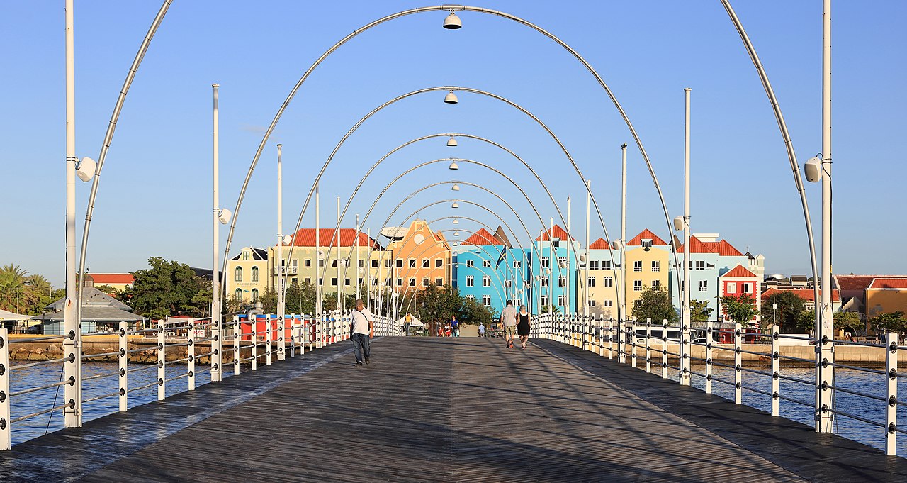
Willemstad ( WIL-əm-staht, VIL-, Dutch: [ˈʋɪləmstɑt] ; Papiamento: [wiləmˈstad]; lit.'William Town') is the capital and largest city of Curaçao, an island in the southern Caribbean Sea that forms a constituent country of the Kingdom of the Netherlands. It was the capital of the Netherlands Antilles prior to its dissolution in 2010. The historic centre of the city consists of four quarters: the Punda and Otrobanda, which are separated by the Sint Anna Bay, an inlet that leads into the large natural harbour called the Schottegat, as well as the ...Read more

Willemstad ( WIL-əm-staht, VIL-, Dutch: [ˈʋɪləmstɑt] ; Papiamento: [wiləmˈstad]; lit.'William Town') is the capital and largest city of Curaçao, an island in the southern Caribbean Sea that forms a constituent country of the Kingdom of the Netherlands. It was the capital of the Netherlands Antilles prior to its dissolution in 2010. The historic centre of the city consists of four quarters: the Punda and Otrobanda, which are separated by the Sint Anna Bay, an inlet that leads into the large natural harbour called the Schottegat, as well as the Scharloo and Pietermaai Smal quarters, which are across from each other on the smaller Waaigat harbour. Willemstad is home to the Curaçao synagogue, the oldest surviving synagogue in the Americas. The city centre, with its unique architecture and harbour entry, has been designated a UNESCO World Heritage Site.

Punda was established in 1634, when the Dutch West India Company captured the island from Spain. The original name of Punda was de punt in Dutch. The city was constructed as a walled city.[1] It soon developed into one of the major centres of the Atlantic slave trade which triggered a rapid population growth.[2] In 1674, the Curaçao synagogue was built by Sephardic Portuguese Jews from Amsterdam and Recife, Brazil who had settled in the city as traders.[3] In the late 17th century, there were over 200 houses within the city walls.[1]

In 1675, it was decided to construct the town of Pietermaai outside of the enclosed city. It was to be separated from the city by an area of about 500 metres in which construction was not allowed as not to obstruct the canons in Fort Amsterdam.[4] In 1707, the suburb of Otrobanda was founded. Otrobanda would become the cultural centre of Willemstad. Its name originated from the Papiamentu otro banda, which means "the opposite side".[5] The suburb of Scharloo followed, however Willemstad continued to experience growth.[2] By 1818, the population of Willemstad had grown to 9,536 people.[6] On 13 May 1861, a decision was made to demolish the city walls, and built residential houses in the gap separating Willemstad from Pietermaai.[2]

Around 1925, the booming oil and phosphate industry further stimulated growth, and resulted in the creation of new neighbourhoods.[7] Between 1945 and 1955, Julianadorp and Emmastad were created by Royal Dutch Shell to house the new workers.[8] In 1985, the oil refinery which employed 12,000 people was closed down by Shell. The Government of Curaçao decided to buy the refinery for ƒ 1.00 and take responsibility for all future pollution claims. In 1986, it was leased to the Venezuelan PDVSA, and reopened on a limited scale.[9] In 2017, the PDVSA was hit by punitive sanctions of the United States Government,[10] and attempts have been made to seize the refinery.[9]

On 30 May 1969, the Curaçao uprising, a strike at a subcontractor of the oil refinery, turned into a riot. The riot resulted in two deaths, 300 arrests and a part of the historic centre burnt down. The Netherlands Marine Corps was sent to Willemstad and the entire city centre was closed down.[11] In 1997, the centre of Willemstad and its former suburbs were designated a UNESCO World Heritage Site.[12] In the 21st century, a large scale program of renovation started.[13][14]

 Willemstad in the late afternoon
^ a b "Pietermaai Suburb". Curaçao History. Retrieved 18 April 2021. ^ a b c Benjamins & Snelleman 1917, p. 747, . ^ "Curacao Virtual Jewish History Tour". Jewish Library. Retrieved 22 April 2021. ^ Michael A. Newton (1990). "Architectuur en monumentenzorg". De Gids (in Dutch). p. 658. ^ Benjamins & Snelleman 1917, p. 747: Dutch: Overzijde English: Opposite side ^ Benjamins & Snelleman 1917, p. 749. ^ Buurtprofiel Steenrijk (2011). "Buurtprofiel Steenrijk" (PDF). Government of Curaçao (in Dutch). p. 9. Retrieved 22 April 2021. ^ "Ontwikkeling huisvesting op Curaçao door Shell". National Archive of Curaçao (in Dutch). Retrieved 20 April 2021. ^ a b "Het rottend hart dat Curaçao splijt: wat moet het eiland met zijn vuile raffinaderij?". de Volkskrant (in Dutch). Retrieved 22 April 2021. ^ "Curacao oil refinery takeover: Good for jobs, bad for climate?". Al Jazeera. Retrieved 22 April 2021. ^ "Curaçao Trinta di Mèi". Dutch National Archive (in Dutch). Retrieved 22 April 2021. ^ "Historische Wijken". Curacao.com. Retrieved 22 April 2021. ^ Buurtprofiel Scharloo (2011). "Buurtprofiel Scharloo" (PDF). Government of Curaçao (in Dutch). p. 10. Retrieved 22 April 2021. ^ "The local SOHO on Curaçao:The Pietermaai District". Dolfijn Go. Retrieved 22 April 2021.
Photographies by:
Matthew T Rader - CC BY-SA 4.0
Statistics: Position
5955
Statistics: Rank
14147

Add new comment

Esta pregunta es para comprobar si usted es un visitante humano y prevenir envíos de spam automatizado.

Security
345697812Click/tap this sequence: 8952

Google street view

Where can you sleep near Willemstad ?

Booking.com
489.298 visits in total, 9.196 Points of interest, 404 Destinations, 125 visits today.