Parque nacional Torres del Paine
( Torres del Paine National Park )
Torres del Paine National Park (Spanish: Parque Nacional Torres del Paine) is a national park encompassing mountains, glaciers, lakes, and rivers in southern Chilean Patagonia. The Cordillera del Paine is the centerpiece of the park. It lies in a transition area between the Magellanic subpolar forests and the Patagonian Steppes. The park is located 112 km (70 mi) north of Puerto Natales and 312 km (194 mi) north of Punta Arenas. The park borders Bernardo O'Higgins National Park to the west and the Los Glaciares National Park to the north in Argentine territory. Paine means "blue" in the native Tehuelche (Aonikenk) language and is pronounced PIE-neh, while Torres means "towers". It was established as a National Park in 1959.
Torres del Paine National Park is part of the Sistema Nacional de Áreas Silvestres Protegidas del Estado de Chile (National System of Protected Forested Areas of Chile). In ...Read more
Torres del Paine National Park (Spanish: Parque Nacional Torres del Paine) is a national park encompassing mountains, glaciers, lakes, and rivers in southern Chilean Patagonia. The Cordillera del Paine is the centerpiece of the park. It lies in a transition area between the Magellanic subpolar forests and the Patagonian Steppes. The park is located 112 km (70 mi) north of Puerto Natales and 312 km (194 mi) north of Punta Arenas. The park borders Bernardo O'Higgins National Park to the west and the Los Glaciares National Park to the north in Argentine territory. Paine means "blue" in the native Tehuelche (Aonikenk) language and is pronounced PIE-neh, while Torres means "towers". It was established as a National Park in 1959.
Torres del Paine National Park is part of the Sistema Nacional de Áreas Silvestres Protegidas del Estado de Chile (National System of Protected Forested Areas of Chile). In 2013, it measured approximately 181,414 hectares (700 sq mi). It is one of the largest and most visited parks in Chile. The park averages around 252,000 visitors a year, of which 54% are foreign tourists, who come from many countries all over the world. It is also part of the End of the World Route, a tourist scenic route.
The park is one of the 11 protected areas of the Magallanes Region and Chilean Antarctica (together with four national parks, three national reserves, and three national monuments). Together, the protected forested areas comprise about 51% of the land of the region (6,728,744 hectares (25,980 sq mi)).
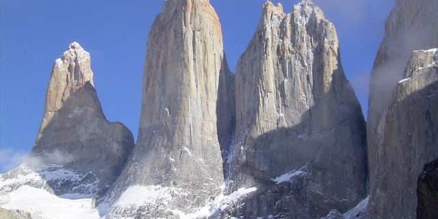
The Torres del Paine are the distinctive three granite peaks of the Paine mountain range or Paine Massif. From left to right they are known as Torre d'Agostini, Torre Central and Torre Monzino. They extend up to 2,500 metres (8,200 ft) above sea level and are joined by the Cuernos del Paine. The area also boasts valleys, rivers such as the Paine, lakes, and glaciers. The well-known lakes include Grey, Pehoé, Nordenskiöld, and Sarmiento. The glaciers, including Grey, Pingo, and Tyndall, belong to the Southern Patagonia Ice Field.
 Torres del Paine
Lady Florence Dixie, in her book published in 1880, gave one of the first descriptions of the area and referred to the three towers as Cleopatra's Needles.[1] She and her party are sometimes credited as being the first "foreign tourists" to visit the area that is now called Torres del Paine National Park.[2]
Several European scientists and explorers visited the area in the following decades, including Otto Nordenskiöld, Carl Skottsberg, and Alberto María de Agostini.[2] Gunther Plüschow was the first person to fly over the Paine massif.
The park was established on 13 May 1959[3] as Parque Nacional de Turismo Lago Grey (Grey Lake National Tourism Park) and was given its present name in 1970.[2]
In 1976, British mountaineer John Garner and two Torres del Paine rangers, Pepe Alarcon and Oscar Guineo pioneered the Circuit trail which circles the Paine massif.[4]
In 1977, Guido Monzino donated 12,000 hectares (30,000 acres) to the Chilean Government when its definitive limits were established.[5] The park was designated a World Biosphere Reserve by UNESCO in 1978.[6]
FiresIn 1985, a tourist started a fire that burned about 150 km2 (58 sq mi) of the park. The blaze affected the areas east and south around Lake Pehoé.[7]
In February 2005, an accidental fire started by a Czech backpacker, which lasted for about ten days, destroyed 155 km2 (60 sq mi) of the park,[7] including about 2 km² of native forest. The Czech government offered aid after the fire and donated US$1 million to reforestation efforts.[8]
In late December 2011 through January 2012, an Israeli backpacker was charged of having started a fire after being caught by a park ranger when lighting up some paper roll in a forbidden area.[9] The backpacker and his family have denied the charges. Subsequently, the Chilean authorities dropped the charges.[10][11] The fire burned about 176 km2 (68 sq mi) of the reserve,[12] destroying about 36 km² of native forest[13] and affecting most of the areas around Lake Pehoé and the western areas around Lake Sarmiento, but moving away from the Cordillera del Paine, the park's centerpiece.[14]
In 2019 an incipient wildfire caused by a cigarette butt was promptly extinguished by nearby fire brigades of the National Forest Corporation.[15]
Nevertheless, recent paleoenvironmental studies performed within the Park indicate that fires have been frequent phenomena at least during the last 12,800 years.[16]


Add new comment