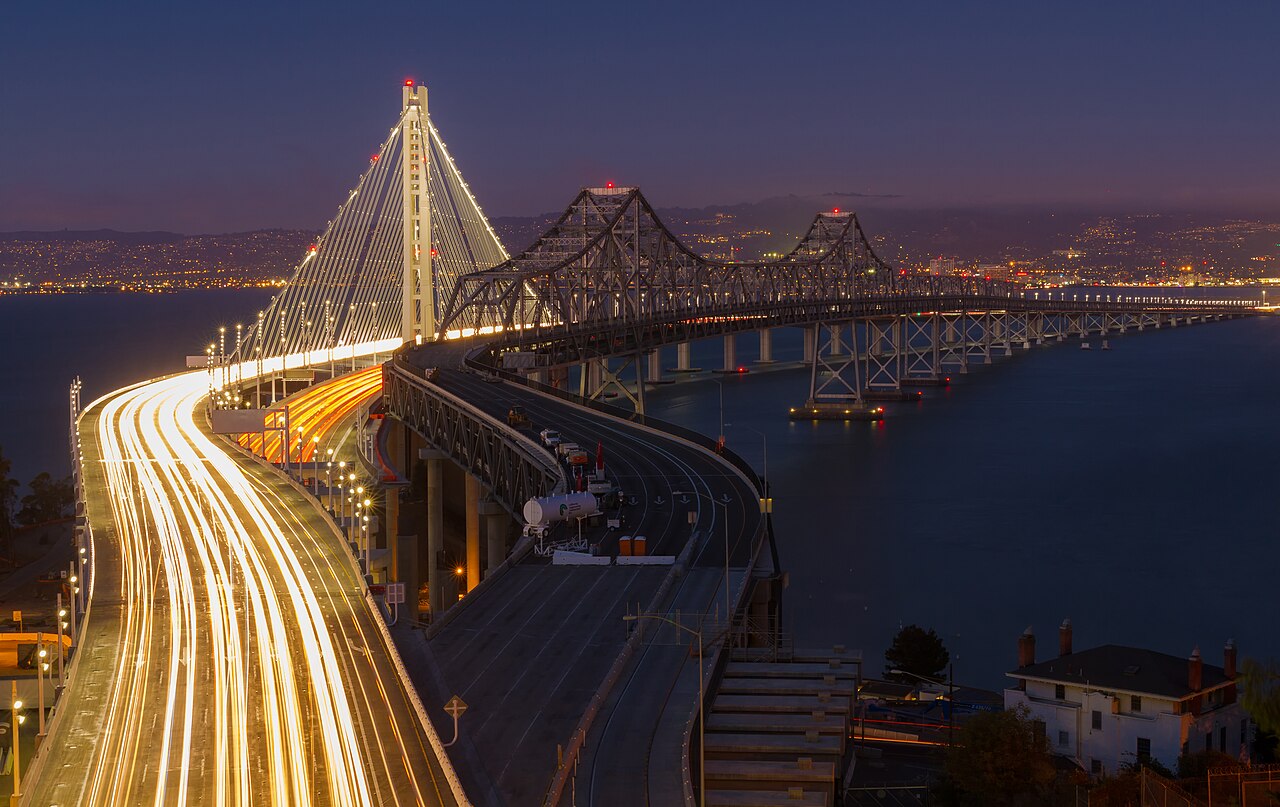
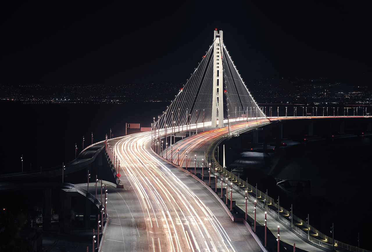
San Francisco–Oakland Bay Bridge
The San Francisco–Oakland Bay Bridge, commonly referred to as the Bay Bridge, is a complex of bridges spanning San Francisco Bay in California. As part of Interstate 80 and the direct road between San Francisco and Oakland, it carries about 260,000 vehicles a day on its two decks. It includes one of the longest bridge spans in the United States.
The toll bridge was conceived as early as the California gold rush days, with "Emperor" Joshua Norton famously advocating for it, but construction did not begin until 1933. Designed by Charles H. Purcell, and built by American Bridge Company, it opened on Thursday, November 12, 1936, six months before the Golden Gate Bridge. It originally carried automobile traffic on its upper deck, with trucks, cars, buses and commuter trains on the lower, but after the Key System abandoned its rail service on April 20, 1958, the lower deck was converted to all-road traffic as well. On October 12, 1963, ...Read more
The San Francisco–Oakland Bay Bridge, commonly referred to as the Bay Bridge, is a complex of bridges spanning San Francisco Bay in California. As part of Interstate 80 and the direct road between San Francisco and Oakland, it carries about 260,000 vehicles a day on its two decks. It includes one of the longest bridge spans in the United States.
The toll bridge was conceived as early as the California gold rush days, with "Emperor" Joshua Norton famously advocating for it, but construction did not begin until 1933. Designed by Charles H. Purcell, and built by American Bridge Company, it opened on Thursday, November 12, 1936, six months before the Golden Gate Bridge. It originally carried automobile traffic on its upper deck, with trucks, cars, buses and commuter trains on the lower, but after the Key System abandoned its rail service on April 20, 1958, the lower deck was converted to all-road traffic as well. On October 12, 1963, traffic was reconfigured to one way traffic on each deck, westbound on the upper deck, and eastbound on the lower deck, with trucks and buses also allowed on the upper deck.
In 1986, the bridge was unofficially dedicated to former California governor James Rolph.
The bridge has two sections of roughly equal length; the older western section, officially known as the Willie L. Brown Jr. Bridge (after former San Francisco Mayor and California State Assembly Speaker Willie L. Brown Jr.), connects downtown San Francisco to Yerba Buena Island, and the newer east bay section connects the island to Oakland. The western section is a double suspension bridge with two decks, westbound traffic being carried on the upper deck while eastbound is carried on the lower one. The largest span of the original eastern section was a cantilever bridge.
During the 1989 Loma Prieta earthquake, a portion of the eastern section's upper deck collapsed onto the lower deck and the bridge was closed for a month. Reconstruction of the eastern section of the bridge as a causeway connected to a self-anchored suspension bridge began in 2002; the new eastern section opened September 2, 2013, at a reported cost of over $6.5 billion; the original estimate of $250 million was for a seismic retrofit of the existing span. Unlike the western section and the original eastern section of the bridge, the new eastern section is a single deck carrying all eastbound and westbound lanes. Demolition of the old east span was completed on September 8, 2018.
Developed at the entrance to the bay, San Francisco was well placed to prosper during the California Gold Rush. Almost all goods not produced locally arrived by ship, as did numerous travelers and erstwhile miners. But after the first transcontinental railroad was completed in May 1869, San Francisco was on the wrong side of the Bay, and separated from the new rail link.
Many San Franciscans feared that the city would lose its position as the regional center of trade. Businessmen had considered the concept of a bridge spanning the San Francisco Bay since the Gold Rush days. During the 1870s, several newspaper articles explored the idea. In early 1872, a "Bay Bridge Committee" was hard at work on plans to construct a railroad bridge. The April 1872 issue of the San Francisco Real Estate Circular reported on this committee:
The Bay Bridge Committee lately submitted its report to the Board of Supervisors, in which compromise with the Central Pacific was recommended; also the bridging of the bay at Ravenswood and the granting of railroad facilities at Mission Bay and on the water front. Wm. C. Ralston, ex-Mayor Selby and James Otis were on this committee. A daily newspaper attempts to account for the advice of these gentlemen to the city by hinting that they were afraid of the railroad company, and therefore made their recommendations to suit its interests.[1]
The self-proclaimed Emperor Norton decreed three times in 1872 that a suspension bridge be constructed to connect Oakland with San Francisco. In the third of these decrees, in September 1872, Norton, frustrated that nothing had happened, proclaimed:
WHEREAS, we issued our decree ordering the citizens of San Francisco and Oakland to appropriate funds for the survey of a suspension bridge from Oakland Point via Goat Island; also for a tunnel; and to ascertain which is the best project; and whereas the said citizens have hitherto neglected to notice our said decree; and whereas we are determined our authority shall be fully respected; now, therefore, we do hereby command the arrest by the army of both the Boards of City Fathers if they persist in neglecting our decrees. Given under our royal hand and seal at San Francisco, this 17th day of September, 1872.[2]
 Sketch of the proposed "Rush San Francisco Trans-Bay Suspension Bridge" (1913)[3]
Unlike most of Emperor Norton's eccentric ideas, his decree to build a bridge had wide public and political appeal. Yet the task was too much of an engineering and economic challenge, since the bay was too wide and too deep there. In 1921, more than forty years after Norton's death, an underground tube was considered, but it became clear that one would be inadequate for vehicular traffic.[4] Support for a trans-bay crossing increased in the 1920s based on the popularity and availability of automobiles.
Planning Preliminary layout studies for the bridge, with Figures "H", and "P" selected as the final construction choice for western and eastern sections
The state legislature and governor passed a law, effective in 1929, to establish the California Toll Bridge Authority (Stats. 1929, Chap 763) and to authorize it and the State Department of Public Works to build a bridge connecting San Francisco and Alameda County (Stats. 1929, Chap 762).[5][6]
The state appointed a commission to evaluate the idea and various designs for a bridge across the Bay, the Hoover-Young Commission. Its conclusions were made public in 1930.[7]
In January 1931, Charles H. Purcell, the State Highway Engineer of California, who had also served as the secretary of the Hoover-Young Commission, assumed the position of Chief Engineer for the Bay Bridge. Glenn B. Woodruff served as design engineer for the project. He explained in a 1936 article that several elements of the bridge required not only new designs, but also new theories of design.[8]
To make the bridge feasible, a route was chosen via Yerba Buena Island, which would reduce both the material and the labor needed. Since Yerba Buena Island was a U.S. Navy base at the time, the state had to gain approval of the U.S. Congress for this purpose, as it regulates the armed services and supervises all naval and military bases. After a great deal of lobbying, California received Congressional approval to use the island on February 20, 1931, subject to final approvals by the Departments of War, Navy and Commerce.[9] The state applied for permits from the 3 federal departments as required. The permits were granted in January 1932, and formally presented in a ceremony on Yerba Buena Island on February 24, 1932.[10]
On May 25, 1931, Governor James Rolph Jr. signed into law two acts: one providing for the financing of state bridges by revenue bonds, and another creating the San Francisco–Oakland Bay Bridge Division of the State Department of Public Works. On September 15, 1931, this new division opened its offices at 500 Sansome Street in San Francisco.[11]
During 1931, numerous aerial photographs were taken of the chosen route for the bridge and its approaches.[12]
That year, engineers had not determined the final design concept for the western span between San Francisco and Yerba Buena Island, although the idea of a double-span suspension bridge was already favored.[13]
In April 1932, the preliminary final plan and design of the bridge was presented by Chief Engineer Charles Purcell to Col. Walter E. Garrison, Director of the State Department of Public Works, and to Ralph Modjeski, head of the Board of Engineering Consultants. Both agencies approved and preparation of the final design proceeded.[14][15] In 1932, Joseph R. Knowland, a former U.S. Congressman from California, traveled to Washington to help persuade President Herbert Hoover and the Reconstruction Finance Corporation to advance $62 million to build the bridge.
Construction The Bay Bridge under construction at Yerba Buena Island in 1935
Before work got underway, 12 massive underwater telephone cables were moved 1,000 feet north of the proposed bridge route by crews of the Pacific Telephone and Telegraph Co. during the summer of 1931.[16]
Construction began on July 9, 1933[17] after a groundbreaking ceremony attended by former president Herbert Hoover, dignitaries, and local beauty queens.[18]
The western section of the bridge between San Francisco and Yerba Buena Island presented an enormous engineering challenge. The bay was up to 100 feet (30 m) deep in places and the soil required new foundation-laying techniques.[4] A single main suspension span some 4,100 feet (1.2 km) in length was considered but rejected, as it would have required too much fill and reduced wharfage space at San Francisco, had less vertical clearance for shipping, and cost more than the design ultimately adopted.[19] The solution was to construct a massive concrete anchorage halfway between San Francisco and the island, and to build a main suspension span on each side of this central anchorage.[20]
East of Yerba Buena Island, the bay to Oakland was spanned by a 10,176-foot (3.102 km) combination of double cantilever, five long-span through-trusses, and a truss causeway, forming the longest bridge of its kind at the time.[4] The cantilever section was longest in the nation and third-longest anywhere.[21]
Much of the original eastern section was founded upon treated wood pilings. Because of the very deep mud on the bay bottom, it was not practical to reach bedrock, although the lower levels of the mud are quite firm. Long wooden pilings were crafted from entire old-growth Douglas fir trees, which were driven through the soft mud to the firmer bottom layers.[22] The construction project had casualties: twenty-four men would die while constructing the bridge.[23]
Approaches A double balanced cantilever bridge, five truss bridges, and two truss causeways that connected Yerba Buena Island to Oakland. It was replaced by the current SAS span and was dismantled in 2016.
The original western approach to (and exit from) the upper deck of the bridge was a long ramp to Fifth Street, branching to Harrison St for westward traffic off the bridge and Bryant St for eastward traffic entering. There was also an on-ramp to the upper deck on Rincon Hill from Fremont Street (which later became an off-ramp) and an off-ramp to First Street (later extended over First St to Fremont St). The lower deck ended at Essex and Harrison St; just southwest of there, the tracks of the bridge railway left the lower deck and curved northward into the elevated loop through the Transbay Terminal that was paved for buses after rail service ended.[24]
The eastern approach to the bridge included a causeway landing for the "incline" section, and the construction of three feeder highways, interlinked by an extensive interchange,[25] which in later years became known as "The MacArthur Maze". A massive landfill was emplaced, extending along the north edge of the existing Key System rail mole to the existing bayshore, and continuing northward along the shore to the foot of Ashby Avenue in Berkeley.[26] The fill was continued northward to the foot of University Avenue as a causeway which enclosed an artificial lagoon, subsequently developed by the WPA as "Aquatic Park". The three feeder highways were U.S. Highway 40 (Eastshore Highway) which led north through Berkeley, U.S. Highway 50 (38th Street, later MacArthur Blvd.) which led through Oakland, and State Route 17 which ran parallel to U.S. 50, along the Oakland Estuary and through the industrial and port sections of the city.
Yerba Buena Tunnel Traveling through the westbound upper level of the Yerba Buena tunnel
The Yerba Buena passage utilizes the Yerba Buena Tunnel, 76 feet (23 m) wide, 58 feet (18 m) high, and 540 feet (160 m) long.[27] It is the largest diameter transportation bore tunnel in the world.[4] The large amount of material that was excavated in boring the tunnel was used for a portion of the landfill over the shoals lying adjacent to Yerba Buena Island to its north, a project which created the artificial Treasure Island.
Reminders of the long-gone bridge railway survive along the south side of the lower Yerba Buena Tunnel. These are the regularly spaced refuge bays ("deadman holes"), escape alcoves common in all railway tunnels, along the wall, into which track maintenance workers could safely retreat if a train came along. (The north side, which always carried only motor traffic, lacks these holes.)[28][29]
Opening dayThe bridge opened on November 12, 1936, at 12:30 p.m. In attendance were the former US president Herbert Hoover, Senator William G. McAdoo, and the Governor of California, Frank Merriam. Governor Merriam opened the bridge by cutting gold chains across it with an acetylene cutting torch.[30] The San Francisco Chronicle report of November 13, 1936, read:
 The illuminated western span as seen from the Embarcadero in San Francisco
 Schematic drawing of the Bay Bridge
the greatest traffic jam in the history of S.F., a dozen old-fashioned New Year's eves thrown into one – the biggest and most good-natured crowd of tens of thousands ever to try and walk the streets and guide their autos on them – This was the city last night, the night of the bridge opening with every auto owner in the bay region, seemingly, trying to crowd his machine onto the great bridge.
And those who tried to view the brilliantly lighted structure from the hilltops and also view the fireworks display were numbered also in the thousands.
Every intersection in the city, particularly those near the San Francisco entrance to the bridge, was jammed with a slowly moving auto caravan.
Every available policeman in the department was called to duty to aid in regulating the city's greatest parade of autos.
One of the greatest traffic congestions of the evening was at Fifth and Mission Streets, with downtown traffic and bridge-bound traffic snarled in an almost hopeless mass. To add to the confusion, traffic signals jammed and did not synchronize.
Police reported that there was no lessening of the traffic over the bridge, all lanes being crowded with Oakland- or San-Francisco-bound machines far into the night.
The total cost was US$77 million.[4] Before opening the bridge was blessed by Cardinal Secretary of State Eugene Cardinal Pacelli, later Pope Pius XII.[31] Because it was in effect two bridges strung together, the western spans were ranked the second and third largest suspension bridges. Only the George Washington Bridge had a longer span between towers.
As part of the celebration a United States commemorative coin was produced by the San Francisco Mint. A half dollar, the obverse portrays California's symbol, the grizzly bear, while the reverse presents a picture of the bridge spanning the bay. A total of 71,369 coins were sold, some from the bridge's tollbooths.[32]
Roadway planUntil the 1960s, the upper deck (58 feet (18 m) wide between curbs) carried three lanes of traffic in each direction and was restricted to automobiles only.[4] The lower deck carried three lanes of truck and bus traffic, with autos allowed, on the north side of the bridge.[4] In the 1950s traffic lights were added to set the direction of travel in the middle lane, but there still remained no divider. Two interurban railroad tracks on the south half of the lower deck carried the electric commuter trains.[33] In 1958 the tracks were replaced with pavement, but the reconfiguration to what the traffic eventually became did not take place until 1963.
The Federal highway on the bridge was originally a concurrency of U.S. Highway 40 and U.S. Highway 50. The bridge was re-designated as Interstate 80 in 1964, and the western ends of U.S. 40 and U.S. 50 are now in Silver Summit, Utah, and West Sacramento, California, respectively.
After the 1960s reconfiguration, there were three total off-ramps to Yerba Buena Island and Treasure Island: a single left-hand side exit in the western direction at the east end of the tunnel, a left-hand side exit in the eastern direction at the west end of the tunnel (originally signed as just "Treasure Island"), and a right-hand side exit in eastern direction at the east end of the tunnel (originally signed as just "Yerba Buena Island").[34][35] The eastbound left exit in particular presented an unusual hazard – drivers had to slow within the normal traffic flow and move into a very short off-ramp that ended in a short radius turn left turn; accordingly, a 15 MPH advisory was posted there. The turn had been further narrowed from its original design by the installation of crash pads on the island side. The eastbound and westbound on-ramps were then on the usual right-hand side, but they did not have dedicated merge lanes, forcing drivers to await gaps in traffic and then accelerate from a stop sign to traffic speeds in a short distance. In 2016, a new on-ramp and off-ramp at the east end of the tunnel were opened in the western direction on the right-hand side of the roadway, replacing the left-hand side off-ramp in that direction.[36] Meanwhile, the eastbound right-hand side off-ramp and on-ramp at the east end of the tunnel was demolished during the reconstruction of the eastern span of the bridge. A new on-ramp on this side was built with a dedicated merge lane, but the off-ramp's replacement was not completed until early-May 2023, well after the bridge's bike path from the Oakland side to the island was fully completed. The eastbound left-hand side off-ramp and westbound on-ramp at the west end of the tunnel are then scheduled then close as early as late-May 2023 while the western span undergoes a seismic retrofit.[34][35]
Rail service A Key System interurban crossing the bridge
Construction of the Bridge Railway began on November 29, 1937, with the laying of the first ties.[37] The first train was run across the Bay Bridge on September 23, 1938, a test run utilizing a Key System train consisting of two articulated units with California Governor Frank Merriam at the controls.[38] On January 14, 1939, the San Francisco Transbay Terminal was dedicated. The following morning, January 15, 1939, the electric interurban trains started in revenue service, running along the south side of the lower deck of the bridge. The terminal originally was supposed to open at the same time as the Bay Bridge, but had been delayed.
Trains over the Bridge Railway were operated by the Sacramento Northern Railroad (Western Pacific), the Interurban Electric Railway (Southern Pacific) and the Key System.[39] Freight trains never used the bridge. The tracks left the lower deck in San Francisco just southwest of the end of 1st St. They then went along an elevated viaduct above city streets, looping around and into the terminal on its east end. Departing trains exited on the loop back onto the bridge.[40] The loop continued to be used by buses until the terminal's closure in 2010. The tracks left the lower deck in Oakland. The Interurban Electric Railway tracks ran along Engineer Road and over the Southern Pacific yard on trestles (some of it is still standing and visible from nearby roadways) onto the streets and dedicated right-of-ways in Berkeley, Albany, Oakland and Alameda. The Sacramento Northern and Key System tracks went under the SP tracks through a tunnel (which still exists and is in use as an access to the EBMUD treatment plant) and onto 40th St. Due to falling ridership, Sacramento Northern and IER service ended in 1941.[41]
 Disused passengers facilities on Yerba Buena Island for riders traveling northbound
On September 13, 1942, a stop was opened at Yerba Buena Island to serve expanded wartime needs on adjacent Treasure Island.[42] After World War II Key System ridership began to fall as well. Despite the vital role the railroad played, the last train went over the bridge in April 1958. The tracks were removed and replaced with pavement on the Transbay Terminal ramps and Bay Bridge. The Key System handled buses over the bridge until 1960 when its successor, AC Transit, took over operations. It still handles service today, running to a new transbay terminal located in the same vicinity in San Francisco, the Transbay Transit Center.
There have been attempts to restore rail service on the bridge, but none have been successful. A study released in 2000 estimated the cost of restoring rail service across the bridge at up to $8 billion ($13.6 billion in 2022).[43]
1963 removal of rails Daytime view of the Bay Bridge and San Francisco seen from Yerba Buena Island
 A view of the Bay Bridge from the Bank of America building
Automobile traffic increased dramatically in the ensuing decades while the Key System declined, and in October 1963, the Bay Bridge was reconfigured with five lanes of westbound traffic on the upper deck and five lanes of eastbound traffic on the lower deck. The Key System originally planned to end train operations in 1948 when it replaced its streetcars with buses, but Caltrans did not approve of this. Trucks were allowed on both decks and the railroad was removed.[4] Owing to a lack of clearance for trucks through the upper-deck portion of the Yerba Buena tunnel, it was necessary to lower the elevation of the upper deck where it passes through the tunnel, and to correspondingly excavate to lower the elevation of the lower portion.[44] Additionally, the upper deck was retrofitted to handle the increased loads due to trucks, with understringers added and prestressing added to the bottom of the floor beams. This retrofit is still in place and is visible to Eastbound traffic.
1968 aircraft accidentOn February 11, 1968, a U.S. Navy training aircraft crashed into the cantilever span of the bridge, killing both reserve officers aboard. The T2V SeaStar, based at NAS Los Alamitos in southern California, was on a routine weekend mission and had just taken off in the fog from nearby NAS Alameda. The plane struck the bridge about 15 feet (5 m) above the upper deck roadway and then sank in the bay north of the bridge.[45] There were no injuries among the motorists on the bridge.[46] One of the truss sections of the bridges was replaced due to damage from the impact.[47]
1986 Cable lightingThe series of lights adorning the suspension cables was added in 1986 as part of the bridge's 50th-anniversary celebration.[48]
2001 terrorism threatOn November 2, 2001, in the aftermath of the September 11 attacks, Governor Gray Davis announced a threat of a rush hour attack against a West Coast suspension bridge (a group which includes the Bay Bridge and the Golden Gate Bridge) some time between November 2 and 7, resulting in increased armed law enforcement patrols.[49][50]
A small fraction of drivers shifted to ferries and BART.[51] It was later revealed that crews had secretly been working under armed guard for several weeks to harden the suspension cable attachment points, which were vulnerable to cutting with common tools. An anchor room was filled with concrete, doors welded shut, and a razor wire fence added. A blast wall was also added to defend against a truck bomb.[51][52] In the end, no attack occurred.
2007 Cosco Busan oil spillIn 2007, a container ship then named the Cosco Busan, and subsequently renamed the Hanjin Venezia, allided with the Delta Tower fender, resulting in the Cosco Busan oil spill.[53][54][55][56]
2013 public "light sculpture" installation A view of Bay Bridge lights from a pier next to the Ferry Building in San Francisco
On March 5, 2013, a public art installation called "The Bay Lights" was activated on the western span's vertical cables. The installation was designed by artist Leo Villareal and consists of 25,000 LED lights originally scheduled to be on nightly display until March 2015.[57] However, on December 17, 2014, the non-profit Illuminate The Arts announced that it had raised the $4 million needed to make the lights permanent; the display was temporarily turned off starting in March 2015 in order to perform maintenance and install sturdier bulbs and then re-lit on January 30, 2016.[58][59]
In order to reduce driver distractions, the privately funded display is not visible to users of the bridge, only to distant observers. This lighting effort is intended to form part of a larger project to "light the bay".[60] Villareal used various algorithms to generate patterns such as rainfall, reflections on water, bird flight, expanding rings, and others. Villareal's patterns and transitions will be sequenced and their duration determined by computerized random number generator to make each viewing experience unique.[61] Owing to the efficiency of the LED system employed, the estimated operating cost is only US$15.00 per night.
The lights were switched off at 8 pm on March 5, 2023 – the 10th anniversary of the artwork – due to their poor condition and increasing maintenance costs. There is a plan to raise additional funds and install a new set of lights later in the year.[62]
2020 bus lane proposalIn January 2020, the AC Transit and BART boards of directors supported the establishment of dedicated bus lanes on the bridge.[63][64] In February 2020, Rob Bonta introduced state legislation to begin planning bus lanes on the bridge.[65]
2023 pro-Palestinian ceasefire protestOn November 16, 2023, around 7:40 AM PST, more than 80 pro-Palestinian protesters blocked the five westbound lanes on Interstate 80 on the eastern span to demand ceasefire to the 2023 Israel–Hamas war. Some of the protesters parked their cars in the five westbound lanes, threw their keys in the bay, rolled out banners demanding ceasefire and an end to genocide in Gaza, and pretended to be in body bags, shutting down the Bay Bridge. This created a traffic jam from the toll plaza in Oakland to the tower of the eastern span. The protesters were arrested by the California Highway Patrol, and all traffic was diverted to Yerba Buena Island. All five westbound lanes were then reopened in the afternoon.[66] Later that evening, at about 5:30 PM PST, on one of the five eastbound lanes, there was a car accident close to the eastern span tower, again closing eastbound traffic for around an hour.[67][68] Eight days later, on November 24, 2023 (the day after Thanksgiving,) more than 100 pro-Palestinian protesters from the same protest group of the one at the eastern span protest, again rolling out two identical banners after a four-day ceasefire took effect between Hamas and Israel. It took place in downtown San Francisco again demanding permanent ceasefire and an end to genocide in Gaza.[69]


 - Public domain")

. - CC BY 2.5")


Add new comment