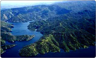
Lake Berryessa is the largest lake in Napa County, California. This reservoir in the Vaca Mountains was formed following the construction of the Monticello Dam on Putah Creek in the 1950s. Since the early 1960s, this reservoir has provided water and hydroelectricity to the North Bay region of the San Francisco Bay Area.

The reservoir was named after the first European settlers in the Berryessa Valley, José Jesús and Sexto "Sisto" Berrelleza (a Basque surname, Anglicized to "Berreyesa", then later respelled "Berryessa"), who were granted Rancho Las Putas in 1843.

Prior to American settlement, the area was home to the Pomo tribe. The valley was an agricultural region, the soil was considered among the finest in the country. The discovery of gold in the foothills of the Sierra Nevada caused an influx of people to the central valley. Communities in Solano County grew quickly in the gold rush. More water was needed to accommodate the rising population, so around the 1940s the Solano County Board of Supervisors organized the Solano County Water Council to search for the best place to develop a water project. Monticello Dam and Lake Berryessa were the result.[1]

Interest in damming Putah Creek started around the early 1900s. In 1907, a few cities in the Bay Area were interested enough to hire three engineers, including Arthur Powell Davis and George Washington Goethals. Their interest quickly evaporated in favor of larger projects, but the place continued to attract interest. Small irrigation projects had developed in the surrounding areas but had little success. In the end the Solano Water Council agreed to focus on Monticello Dam. The original plan included alterations to both Putah Creek and Cache Creeks but complications led to a simpler plan which only dammed Putah Creek at Devil's Gate, which the Bureau of Reclamation assured engineers and planners was the most feasible spot to place a dam on Putah Creek.

The main town in the valley, Monticello, was abandoned in order to construct the reservoir. This abandonment was chronicled by the photographers Dorothea Lange and Pirkle Jones in their work Death of a Valley, published in Aperture magazine in 1960.[2]Some predicted the dam would be unsuccessful and the valley would never fill.[3] Construction of Monticello Dam began in 1953,[4] completed in 1958, and the reservoir filled by 1963, creating what at the time was the second-largest reservoir in California after Shasta Lake. The Monticello Dam with Lake Berryessa, Putah Diversion Dam with Lake Solano, and associated water distribution systems and lands are known collectively as the Solano Project, which is distinct from other water projects in California such as the Central Valley Project.

Monticello residents opposed the government and the Solano Project but were unsuccessful. Residents abandoned their homes, the Monticello cemetery had to be relocated, and houses were destroyed. Monticello ranchers were evicted as equipment was auctioned away and the fertile land destroyed and flooded.[1]

Monticello, a small farming town was founded by Ezra Peacock in 1867. By the time of the evacuations for the dam it had a population of about 250 with some scattered on the outskirts in the valley. Putah Creek was the town's life source, it provided them with close access to water for both crop and livestock raising.

A few years after the completion of the dam, Governor Edmund G. Brown proposed a new project to build an even bigger dam and a larger lake. The "Greater Berryessa Project" was envisioned to be a much larger project; the 304-foot dam would be replaced with a 600-foot dam that would be capable of holding ten times the amount of water, expanding the lake to three times the current size, flooding productive farmland. The project's primary purpose was storage of northern water for use in parts of southern California.[3]

^ a b "Quail Ridge Reserve Human History- Lake Beryessa". Archived from the original on 2014-08-27. Retrieved 2006-02-28. ^ Lange, Dorothea; Jones, Pirkle (Fall 1960). "Death of a Valley". Aperture. ISSN 0003-6420. ^ a b "Solano Project; Project History". Folsom, CA: US Bureau of Reclamation. 2011-05-17. Archived from the original on 2016-03-30. ^ "Berryessa Facts". Mid-Pacific Region. Sacramento, CA: US Bureau of Reclamation. Archived from the original on 22 April 2014.
Photographies by:
Jeremybrooks (talk · contribs) - Public domain
Statistics: Position
2335
Statistics: Rank
53092

Add new comment

Esta pregunta es para comprobar si usted es un visitante humano y prevenir envíos de spam automatizado.

Security
697435281Click/tap this sequence: 6428

Google street view

Where can you sleep near Lake Berryessa ?

Booking.com
490.016 visits in total, 9.198 Points of interest, 404 Destinations, 65 visits today.