أهوار العراق
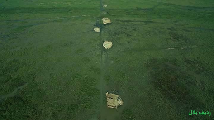
( Mesopotamian Marshes )The Mesopotamian Marshes, also known as the Iraqi Marshes, are a wetland area located in Southern Iraq and southwestern Iran as well as partially in northern Kuwait. The marshes are primarily located on the floodplains of the Euphrates and Tigris rivers bound by the cities of Basra, Nasiriyah, Amarah and a portion of southwestern Iran and northern Kuwait (particularly Bubiyan Island). Historically the marshlands, mainly composed of the separate but adjacent Central, Hawizeh and Hammar Marshes, used to be the largest wetland ecosystem of Western Eurasia. The unique wetland landscape is home to the Marsh people, who have developed a unique culture tightly coupled to the landscape – harvesting reeds and rice, fishing and herding water buffalo.
Draining of portions of the marshes began in the 1950s and continued through the 1970s to reclaim land for agriculture and oil exploration. In the late 1980s and 1990s, during the presidency of Saddam Hussein, this work was ex...Read more
The Mesopotamian Marshes, also known as the Iraqi Marshes, are a wetland area located in Southern Iraq and southwestern Iran as well as partially in northern Kuwait. The marshes are primarily located on the floodplains of the Euphrates and Tigris rivers bound by the cities of Basra, Nasiriyah, Amarah and a portion of southwestern Iran and northern Kuwait (particularly Bubiyan Island). Historically the marshlands, mainly composed of the separate but adjacent Central, Hawizeh and Hammar Marshes, used to be the largest wetland ecosystem of Western Eurasia. The unique wetland landscape is home to the Marsh people, who have developed a unique culture tightly coupled to the landscape – harvesting reeds and rice, fishing and herding water buffalo.
Draining of portions of the marshes began in the 1950s and continued through the 1970s to reclaim land for agriculture and oil exploration. In the late 1980s and 1990s, during the presidency of Saddam Hussein, this work was expanded and accelerated to evict Marsh people from the marshes. Before 2003, the marshes were drained to 10% of their original size. After the American overthrow of Hussein in 2003, the marshes have partially recovered but drought along with upstream dam construction and operation in Turkey, Syria and Iran have hindered the process. Since 2016 the Mesopotamian marshes have been listed as an UNESCO Heritage Site.
In the 4th millennium BCE, the first literate societies emerged in Southern Mesopotamia, often referred to as the "Cradle of Civilization", and the first cities and complex state bureaucracies were developed there during the Uruk period. Due to the geographical location and ecological factors of the Fertile Crescent, a crescent-shape fertile area running from the basins of the Nile in Egypt, northwards along the Mediterranean coast in Palestine and Israel, and southwards again along the Euphrates and the Tigris towards the Persian Gulf, civilizations were able to develop agricultural and technological programmes. The crucial trigger was the availability of wild edible plant species. Farming arose early in the Fertile Crescent because the area had a large quantity of wild wheat and pulse species that were nutritious and easy to domesticate.[1]
In the 10th and 11th centuries, the marshes were the site of the state of Batihah founded by 'Imran ibn Shahin.
Draining and subsequent restoration efforts 1994 map of the Mesopotamian Marshes with draining featuresThe draining of Mesopotamian Marshes began in the 1950s with the Central Marshes and gradually accelerated as it affected the two other main marshes until early in the 21st century with the 2003 invasion of Iraq. The draining of the marshes was intended at first to reclaim land for agriculture along with oil exploration but later served as a punishment for Shia Arabs in response to the 1991 uprisings in Iraq. The draining of the marshes was largely due to dams, dykes and other diversion structures constructed into Iraq but were exacerbated by upstream dam construction in Syria and Turkey.[2]
While the British engineers worked with the Iraqi government, Frank Haigh developed the Haigh Report in 1951. His report recommended a complex of canals, sluices, and dykes on the lower portions of both the Tigris and Euphrates. These water control structures could be used to drain marshes therefore creating profitable farmland. In 1953, construction began on the Third River or Main Outfall Drain and later the Saddam River which would drain water from the Central Marsh under the Euphrates and through a canal eventually into the Persian Gulf.[2] Work on the Third River and other draining projects, particularly for the Hawizeh Marsh, quickly progressed in the 1980s during the Iran–Iraq War in order to afford Iraqis a tactical advantage in the marshes.[3] Part of the Hammar Marshes was also drained in 1985 to clear area for oil exploration.[4]
After the 1991 Gulf War, Shia Muslims in southern Iraq rebelled against Saddam Hussein, who in turn crushed the rebellion and further accelerated the draining of the Central and Hammar marshes in order to evict Shias that have taken refuge in the marshes.[3] With the exception of the Nasiriyah Drainage Pump Station, the 565 km (351 mi) Third River was completed in 1992 and two other canals were constructed south and nearly parallel to it. One, the Mother of Battles canal, was constructed to divert the flow of the Euphrates south below the Hammar Marsh. Second, the 240 km Loyalty to Leader Canal also known as the Basrah Sweetwater Canal, which originates in the lower Euphrates region, collected water from the terminus of the Gharraf River and diverted it under the Euphrates, away from the Central Marshes and below the Hammar Marshes towards Basrah.[3][5] The Glory River was also constructed to divert water from the Tigris's southern-flowing distributaries east and parallel along the Tigris until they reached the Euphrates near its confluence with the Tigris at Qurna.[3]
By the 2003 invasion of Iraq, the marshes had lost 90% of their size from the previous decades.[6] The Central and Hammar Marshes were nearly drained and only 35% of the Hawizeh Marshes remained.[7] After the invasion, locals destroyed dikes. The combined efforts of the Iraq government, United Nations, U.S. agencies and record precipitation in Turkey helped begin a restoration of the marshes.[8] As of late 2006, 58% of the original marshes had been reinundated.[9] The Nasiriyah Drainage Pump Station was completed in 2009, affording the Third River to be used for agricultural drainage.[10] Recent drought and continued upstream dam construction and operation in Turkey, Syria, and Iran have reduced the marshes to around 30% of their original size by 2009.[11] Turkey has built at least 34 dams on the Tigris and Euphrates rivers, threatening marsh recovery.[12][13][14][15]
From a high of around 75% restored in 2008, the wetlands receded to 58% of their average pre-drained level by spring 2015. Meanwhile, as the water level fell, salinity increased to 15,000 parts per million in some areas, up from 300 to 500 ppm in the 1980s. "When the river water levels were high, the low-saline Tigris washed over the marshes, cleansed them, and pushed the salty residue into the saltier Euphrates, which flows along the western edge. But now the Tigris is so low that the Euphrates provides most of the water in the marshes."[16]
The government prioritizes providing water to cities along the Tigris and Shatt al-Arab, resulting in reduced flow to the marshes.[17]
Threats From Climate Change and PollutionTemperatures in the region have risen over 0.5 degrees Celsius per decade, causing drought in Iraq and in neighbors whose waters flow into the Tigris and Euphrates.[17] Combined with upriver dams, this reduction in water has caused the three primary marshes to fragment into 10 smaller marshes.[18]
Massive amounts of untreated sewage and other pollutants are dumped into the Tigris and Euphrates, moving downstream into the marshes and further degrading the water quality.[17][19][20]
Add new comment