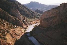
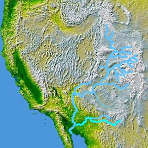
The Gila River (; O'odham [Pima]: Keli Akimel or simply Akimel, Quechan: Haa Siʼil, Maricopa language: Xiil) is a 649-mile-long (1,044 km) tributary of the Colorado River flowing through New Mexico and Arizona in the United States. The river drains an arid watershed of nearly 60,000 square miles (160,000 km2) that lies mostly within the U.S., but also extends into northern Sonora, Mexico.
Indigenous peoples have lived along the river for at least 2,000 years, establishing complex agricultural societies before European exploration of the region began in the 16th century. European Americans did not permanently settle the Gila River watershed until the mid-19th century.
During the 20th century, development in the Gila River watershed prompted the construction of large diversion and flood control structures on the river and its tributaries, and consequently the Gila contributes only a small fraction of its histori...Read more
The Gila River (; O'odham [Pima]: Keli Akimel or simply Akimel, Quechan: Haa Siʼil, Maricopa language: Xiil) is a 649-mile-long (1,044 km) tributary of the Colorado River flowing through New Mexico and Arizona in the United States. The river drains an arid watershed of nearly 60,000 square miles (160,000 km2) that lies mostly within the U.S., but also extends into northern Sonora, Mexico.
Indigenous peoples have lived along the river for at least 2,000 years, establishing complex agricultural societies before European exploration of the region began in the 16th century. European Americans did not permanently settle the Gila River watershed until the mid-19th century.
During the 20th century, development in the Gila River watershed prompted the construction of large diversion and flood control structures on the river and its tributaries, and consequently the Gila contributes only a small fraction of its historic flow to the Colorado. The historic natural discharge of the river was around 1,900 cubic feet per second (54 m3/s), but has declined to only 247 cubic feet per second (7.0 m3/s). The engineering projects transformed much of the river valley and its surroundings from arid desert into irrigated land, and supply water to more than 6 million people in the Phoenix and Tucson metropolitan areas who live in the watershed.


Add new comment