White Sands National Park
A fossil trackway of footprints of humans and ground sloths found at White Sands shows that ground sloths were hunted by humans during the Last Glacial Maximum.[1] Multiple human footprints are stratigraphically constrained and bracketed by seed layers that yield calibrated radiocarbon ages between ~23 and 21 thousand years ago.[2] Paleo-Indians inhabited the shoreline of Lake Otero, a large lake that covered much of the Tularosa Basin. They used stone from the mountains to create projectile points, known as Folsom and Plano points, and attached them to spears for hunting mammoths, camels, ground sloths, and bison. Projectile points and stone tools have been found in the basin associated with ancient shorelines, streams, and hills. As the large ice sheet that capped the North American continent receded, Lake Otero began to evaporate, leaving behind Alkali Flat and Lake Lucero. The grassland died and the basin became increasingly arid, slowly changing into desert scrubland. The megafauna disappeared from the basin leaving behind fossil footprints.[3]
The Archaic people improved upon the hand thrown spear used by Paleo-Indians with the invention of the atlatl. After Lake Otero dried out, wind carried large quantities of gypsum sand up from the basin floor which accumulated into a large dunefield. Archaic people entered the Tularosa Basin about 4,000 years ago, after the dunes had stabilized, possibly attracted by a cereal grass called Indian ricegrass. The first evidence of agriculture is found in the Archaic period. Archaic peoples would tend to wild plants so they would produce in a more reliable manner and in larger quantities than they did naturally. Archaic people started living in small villages throughout the year to tend their fields. Hearth mounds are found within the dunes, which are the remains of prehistoric fires containing charcoal and ash. When gypsum is heated to 300 °F (149 °C) it becomes a plaster that hardens when moisture is added and subsequently evaporates. The plaster cements these hearths in place, preserving them for thousands of years.[4]
The Jornada Mogollon people made pottery, lived in permanent houses, and farmed the Tularosa Basin. Evidence of their prehistoric presence dates back to about 200 CE. The Jornada Mogollon inhabited the basin until about 1350 CE when they moved away, leaving behind puddled adobe structures and pottery sherds.[5]

Over 700 years ago, bands of Apaches followed herds of bison from the Great Plains to the Tularosa Basin.[5] The Apaches were nomadic hunters and gatherers who lived in temporary houses known as wickiups and teepees. The Apaches had established a sizable territory in southern New Mexico by the time European explorers arrived. They fiercely defended the rights to their homeland against the encroachment of colonial settlers. Apache groups, led by Victorio and Geronimo, fought with settlers in the basin and engaged in military battles with Buffalo Soldiers. The Battle of Hembrillo Basin in 1880 was a military engagement between Victorio's warriors and the United States Army's 9th Cavalry Regiment of Buffalo Soldiers. The battleground, located on White Sands Missile Range, is the closest archaeological evidence of the Apache Wars (1849 to 1924). Conflict between the Apaches and the American settlers over their conflicting interests in the basin ultimately ended in the forceful removal of the Apaches from their homelands to the Mescalero Apache Indian Reservation. The Mescalero Apache maintain an active cultural affinity to the landscape of their ancestors.[6]
Euro-AmericansWhile a Spanish colony was established to the north around Santa Fe, the Tularosa Basin was generally avoided until the nineteenth century. The basin lacked any reliable water sources and was the primary stronghold of local Apaches who stole livestock from Pueblo and Spanish settlements near the basin. When Spaniards did enter the basin, they traveled along established trails to the salt pan north of Alkali Flat.[7] Spanish colonists had established the salt trails in 1647, to connect the salt deposits with the Camino Real in El Paso del Norte (present-day Ciudad Juárez) and silver mines in Durango, Mexico. Salt is a fundamental element in the processing of silver ore. Expeditionary parties using mule-drawn carts with military escorts would be formed a few times each year for the journey to the salinas (salt pans).[8]
Hispanic populations throughout the Spanish colonial and Mexican periods were allowed to gather salt from the salinas, which were considered public property. Texan-American settlers made private claims to the land to profit from mining of minerals on their property. James Magoffin held a title to the salt flats north of Lake Lucero but had been unsuccessful in collecting fees for salt gathering. In 1854, using military force, he intercepted a salt gathering expedition of Hispanos from Doña Ana at the salt flats and fatally wounded three members of the party. In response to Magoffin's use of extreme force during the Magoffin Salt War, the courts dissolved his property claim to the salt flats and established a precedent for free public access to salt deposits.[8]
The first US Army exploration of south-central New Mexico was led by a party of topographical engineering officers in 1849. They passed west of the San Andres Mountains and Organ Mountains. A lieutenant was dispatched east across the basin with a scouting party to map a potential military wagon route to the Sierra Blanca.[9]: 6
Hispanic families started farming communities at Tularosa in 1861 and La Luz in 1863. The villagers mixed water with gypsum sand from the dunefield to create plaster for the adobe walls of their homes. The white color was not only decorative but functional in deflecting the rays of the summer sun.[9]: 6

In the 1880s, a brief period of heavy rainfall supported the return of lush grasslands in the Tularosa Basin which attracted the attention of goat, sheep, and cattle grazers, predominately from Texas. Large cattle drives pushed into the basin, and ranching became the dominant economy for the next sixty years. In 1897, the Lucero brothers, Jose, Felipe, and Estevan, began ranching on the south shore of the lake that would eventually bear their name. By 1940, Felipe consolidated the family's ranches into a 20,000-acre (31 sq mi; 81 km2) property. Shortly afterward, the National Park Service took over ownership of the Lucero family properties with their appropriation of Lake Lucero and Alkali Flat. The remnants of the Lucero family ranch include the stock pens, watering trough, a water well, and a fallen windmill which visitors can see on a ranger-led tour to Lake Lucero once each month, in the cooler months of the year.[10]
At the turn of the twentieth century, the discovery of oil, coal, silver, gold, and other precious mineral deposits inspired many settlers to cover the Tularosa Basin in mining claims. By 1904, over 114 people made mineral claims to more than 10,400 acres (16.3 sq mi; 42 km2) of Lake Lucero; however, very few of the claims were developed. Eddy's Soda Prospect, developed by the same Eddy brothers that had founded the El Paso and Northeastern Railway and the town of Alamogordo, was a mineral recovery operation for glauberite salt mining along the southern shore of Lake Lucero. In 1907, J.R. Milner and Bill Fetz constructed a plaster of Paris batching plant along the southern edge of the dunes. The operation involved drilling long shafts into the dunes and extracting gypsum to cook into plaster at night. Though successful, the establishment of the national monument permanently shut down the plant.[11]
National monument
The idea of creating a national park to protect the white sands formation dates to 1898 when a group from El Paso, Texas, proposed the creation of Mescalero National Park. The plan failed as it included a game hunting preserve that conflicted with the idea of preservation held by the Department of the Interior.[9]: 17 [12]: 52–53
From 1912 to 1922, Albert B. Fall, a Senator from New Mexico—later appointed Secretary of the Interior—and the owner of a large ranch in Three Rivers northeast of the dune field, promoted four separate bills in Congress for a national park in the Tularosa Basin. Fall's ultimate plan was called the All-Year National Park as it would be open throughout the year, unlike more northerly parks. The bill included four geographically separate and diverse areas, to be administered as one national park. The proposed areas included a 2,000-acre (3.1 sq mi; 8.1 km2) scenic portion of the Mescalero Indian reservation, 640 acres (1.0 sq mi; 2.6 km2) of the dune field, 640 acres of a volcanic area to the north named Carrizozo Malpais, and the shoreline of the Elephant Butte Reservoir to the west, beyond the San Andres Mountains. Stephen Mather, the director of the National Park Service, criticized the proposal as having "disjointed boundaries, lack of spectacular scenery, and questionable usage." The National Parks Association and the Indian Rights Association campaigned against Fall's bill, mainly because of the appropriation of Indian reservation land and that it might establish a precedent of industrial usage within parks. The bill failed in Congress, and Fall resigned in 1923 during the Teapot Dome scandal.[9]: 22–28 [12]: 61–70
During the 1920s, an Alamogordo businessman named Tom Charles promoted the potential economic benefits of protecting the white sands formation. Charles mobilized enough local support for the construction of an improved state route between Las Cruces and Alamogordo (now U.S. Route 70), passing the southern edge of the dune field. He lobbied to have the dunes declared a national park but was advised by Senator Bronson M. Cutting, who had influence with President Herbert Hoover, that national monument status would be much easier to obtain.[9]: 28–32 [12]: 77–89
On January 18, 1933, President Hoover designated White Sands National Monument, acting under the authority of the Antiquities Act of 1906.[9]: 33 [13] The dedication and grand opening was on April 29, 1934.[12]: 102 Tom Charles became the first custodian of the monument,[9]: 35 [12]: 99 and the first concessionaire in 1939, operating as White Sands Service Company.[9]: 72 [12]: 117
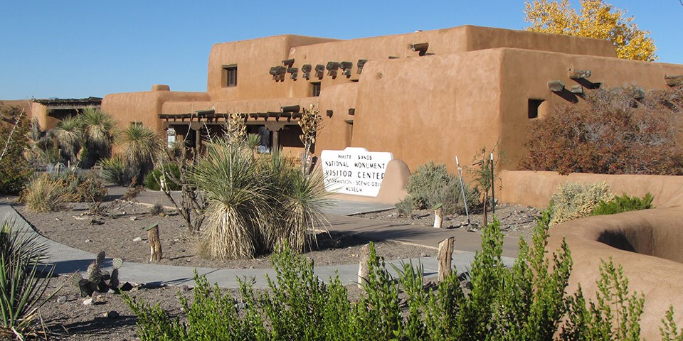
The visitor center and a nearby comfort station, three ranger residences, as well as three maintenance buildings were constructed of adobe bricks as a Works Progress Administration project starting in 1936 and completed in 1938.[14][15] The original eight adobe buildings and other nearby structures were designated the White Sands National Monument Historic District when they were added to the National Register of Historic Places in 1988. The principal architects were Lyle E. Bennett and Robert W. Albers, who also designed NPS buildings together at Casa Grande and Bandelier national monuments.[16] Bennett also designed the picnic table shelters at White Sands, the Painted Desert Inn at Petrified Forest, and buildings at Carlsbad Caverns and Mesa Verde national parks.[15]

The park is completely surrounded by the military installations of White Sands Missile Range and Holloman Air Force Base, and has always had an uneasy relationship with the military.[12]: 131, 175 The missile range and air force base were established after the bombing of Pearl Harbor in 1941, with continuing operations after World War II and throughout the Cold War.[18] Errant missiles often fell within the park's boundaries, occasionally destroying some of the visitor areas.[9]: 145 Overflights from Holloman disturbed the tranquility of the area.[12]: 149 Flight training missions continue over the dunefield,[18] and the park closes temporarily for several hours during missile tests in the adjacent range and cooperative use area on the west side of the park.[19]
Between 1969 and 1977, 95 oryx were released on the missile range and adjacent areas of the Tularosa Basin by the New Mexico Department of Game and Fish for hunting purposes. The oryx, having no natural predators, entered the park and competed with native species for forage.[9]: 172 Thousands of oryx reside on the missile range presently, though annual hunts have occurred since 1974 to help control and stabilize the population. The National Park Service, concerned about the negative effects on native plants and animals within the park, erected a 67-mile (108 km) long boundary fence in 1996 to prevent oryx from entering.[20]
Increasingly problematic alcohol abuse by students on spring break in the 1990s led to a ban on the consumption of alcohol.[21] The possession of alcohol or alcohol containers is banned throughout the park from February 1 to May 31.[22]
World Heritage Site controversyWhite Sands was placed on a tentative list of potential World Heritage Sites on January 22, 2008.[23] The state's two U.S. Senators, Pete Domenici and Jeff Bingaman, wrote letters of support of the application.[24] U.S. Representative Steve Pearce declined to support the application, saying, "I would guarantee that if White Sands Monument receives this designation, that there will at some point be international pressures exerted that could stop military operations as we know them today."[25]
The WHS application generated much controversy in Otero County, most of it taking place in meetings of the Otero County Commission. A petition with 1,200 signatures opposing the application was presented to the commission on August 16, 2007.[26] The commission passed a resolution of opposition to the application on August 23, 2007,[27] and passed Ordinance 07-05 on October 18, 2007, relating to any potential World Heritage Site designations within the county. The ordinance requires coordination with the county in following its environmental planning and review process through its Public Land Use Advisory Council, and states that "No world heritage site...will be located on or adjacent to any military land...within or adjacent to the boundaries of Otero County."[28] On January 24, 2008, after the WHS tentative list was announced, the commission instructed the county attorney to write a letter to the Secretary of the Interior, demanding that WSNM be taken off the list.[29]
National park billIn May 2018, U.S. Senator Martin Heinrich (Democrat, New Mexico) introduced a bill to designate White Sands a national park.[30] Heinrich consulted with monument officials, the National Park Service, White Sands Missile Range, the U.S. Army and Holloman Air Force Base before the bill was introduced in Congress. The bill was supported by the Alamogordo City Commission, the Las Cruces City Council, the Mescalero Apache Tribal Council, the Town of Mesilla Board of Trustees, Alamogordo Mayor Richard Boss, New Mexico Senator Ron Griggs (Republican), the Alamogordo Chamber of Commerce, the Greater Las Cruces Chamber of Commerce, the Las Cruces Green Chamber of Commerce, the National Parks Conservation Association and the Southern New Mexico Public Lands Alliance. The bill was opposed, however, by Otero County commissioners, who stated that the main argument in favor of national park status was the potential for increased visitation, while also noting that the monument is already the most-visited NPS site in the state. The commissioners were also concerned that "the change in status will affect filmmaking here either from higher fees or increased regulation." The commissioners only supported boundary adjustments and additional infrastructure, such as campgrounds and improved road access.[31] The Doña Ana County commissioners also opposed the redesignation of White Sands as a national park.[32]: 5 The redesignation bill was re-introduced on March 27, 2019.[33][34]
On December 11, 2019, the U.S. House of Representatives passed the National Defense Authorization Act for Fiscal Year 2020, which includes legislation redesignating White Sands National Monument as White Sands National Park.[35] The Senate passed the act on December 16 and President Donald Trump signed the bill on December 20. The act includes the transfer of land management both to and from the missile range, as well as the protection of additional land, adding a net 2,029 acres (3.2 sq mi; 8.2 km2) to the park.[36][37]
FilmingWhite Sands, during its period as a national monument, has been used as a filming location for scenes in several westerns, including Four Faces West (1948), Hang 'Em High (1968), The Hired Hand (1971), My Name Is Nobody (1973), Bite the Bullett (1975), and Young Guns II (1990).[38] Additional feature-length films with location shooting in the park include King Solomon's Mines (1950), The Man Who Fell to Earth (1976), White Sands (1992), Transformers (2007),[32]: 4 Transformers 2 (2009), The Men Who Stare at Goats (2009), Year One (2009), and The Book of Eli (2010).[39] The opening scene in the music video for Lady Gaga's 911 (2020),[40] and Wye Oak's title track for the album The Louder I Call, the Faster It Runs (2018) were filmed at White Sands.[41] Yoga Mind & Body (1994), featuring yoga teacher Erich Schiffmann and actress Ali MacGraw, was also filmed on the dunes.[42]


Afegeix un nou comentari