Xochimilco
Xochimilco (Spanish pronunciation: [ʃotʃiˈmilko]; Classical Nahuatl: Xōchimīlco, pronounced [ʃoːtʃiˈmiːlko] ) is a borough (demarcación territorial) of Mexico City. The borough is centered on the formerly independent city of Xochimilco, which was established on what was the southern shore of Lake Xochimilco in the precolonial period.
Today, the borough consists of the 18 barrios, or neighborhoods, of this city along with 14 pueblos, or villages, that surround it, covering an area of 125 km2 (48 sq mi). The borough is in the southeastern part of the city and has an identity that is separate from the historic center of Mexico Ci...Read more
Xochimilco (Spanish pronunciation: [ʃotʃiˈmilko]; Classical Nahuatl: Xōchimīlco, pronounced [ʃoːtʃiˈmiːlko] ) is a borough (demarcación territorial) of Mexico City. The borough is centered on the formerly independent city of Xochimilco, which was established on what was the southern shore of Lake Xochimilco in the precolonial period.
Today, the borough consists of the 18 barrios, or neighborhoods, of this city along with 14 pueblos, or villages, that surround it, covering an area of 125 km2 (48 sq mi). The borough is in the southeastern part of the city and has an identity that is separate from the historic center of Mexico City, due to its historic separation from that city during most of its history.
Xochimilco is best known for its canals, which are left from what was an extensive lake and canal system that connected most of the settlements of the Valley of Mexico. These canals, along with artificial islands called chinampas, attract tourists and other city residents to ride on colorful gondola-like boats called trajineras around the 170 km (110 mi) of canals. This canal and chinampa system, as a vestige of the area's precolonial past, has made Xochimilco a World Heritage Site. In 1950, Paramahansa Yogananda, in his Autobiography of a Yogi, wrote that if there were a scenic beauty contest, Xochimilco would get the first prize.
 Xochimilco's Aztec glyph
 Petroglyph at Cuauhilama
 Trajinera in San Andrés Mixquic with La Calavera Catrina for Day of the Dead
The name "Xochimilco" comes from Nahuatl and means "flower field." This referred to the many flowers and other crops that were grown here on chinampas since the pre-Hispanic period.[1]
The first human presence in the area was of hunter gatherers, who eventually settled into farming communities.[2] The first settlements in the Xochimilco area were associated with the Cuicuilco, Copilco and Tlatilco settlements during the Classic period. The Xochimilca people, considered one of the seven Nahua tribes that migrated into the Valley of Mexico, first settled around 900 BC in Cuahilama, near what is now Santa Cruz Acalpixca. They worshipped sixteen deities, with Chantico, goddess of the hearth; Cihuacoatl, an earth goddess; and Amimitl, god of chinampas, the most important.[3][4]
The Xochimilcas were farmers and founded their first dominion under a leader named Acatonallo. He is credited with inventing the chinampa system of agriculture to increase production. These chinampas eventually became the main producer, with crops such as corn, beans, chili peppers, squash, and more. The city of Xochimilco was founded in 919. Over time, it grew and began to dominate other areas on the south side of the lakes such as Mixquic, Tláhuac, Culhuacan and even parts of what is now the State of Morelos. Xochimilco had one woman ruler, which did not happen anywhere else in Mesoamerica in the pre-Hispanic period. She is credited with adding a number of distinctive dishes to the area's cuisine, with inclusions such as necuatolli, chileatolli (atole with chili pepper), esquites and tlapiques.[3]
In 1352, then emperor Caxtoltzin moved the city from the mainland to the island of Tlilan. In this respect it was like another island city in the area, Tenochtitlan. Although no longer an island, the city center is still in the same spot.[3][1] In 1376, Tenochtitlan attacked Xochimilco, forcing the city to appeal to Azcapotzalco for help. The conquest was unsuccessful, but Xochimilco was then forced to pay tribute to Azcapotzalco. Tenochtitlan succeeded in conquering Xochimilco in 1430, while it was ruled by Tzalpoyotzin. Shortly thereafter, Aztec emperor Itzcoatl built the causeway or calzada that would connect the two cities over the lake. During the reign of Moctezuma Ilhuicamina, the Xochimilcas contributed materials and manpower to construct a temple to Huitzilopochtli. They also participated in the further conquests of the Aztec Empire such as in Cuauhnáhuac (Cuernavaca), Xalisco and the Metztitlán and Oaxaca valleys. For their service, Ahuizotl, granted the Xochimilcas autonomy in their lands, and the two cities coexisted peacefully.[3] Aztec emperors would pass by here on royal barges on their way to Chalco/Xico, then an island in Lake Chalco.[5] For centuries Xochimilco remained relatively separate from Mexico City but provided much of the larger city's produce.[6]
Aztec emperor Moctezuma Xocoyotzin imposed a new governor, Omácatl, onto Xochimilco due to the arrival of the Spanish, but this governor was forced to return to Tenochtitlan, when the emperor was taken prisoner. He was then succeeded by Macuilxochitecuhtli, but eighty days later he too went to Tenochtitlan to fight the Spanish alongside Cuitláhuac. He was followed by Apochquiyautzin, who remained loyal to Tenochtitlan. For this reason, Hernán Cortés decided to send armies to subdue Xochimilco before taking Tenochtitlan. This occurred on 16 April 1521. During the battle, Cortés was almost killed when he fell off his horse, but he was saved by a soldier named Cristóbal de Olea. The battle was fierce and left few Xochimilca warriors alive. The invaders later raped and pillaged the city.[7] According to legend, it was after this battle that Cuauhtémoc came to Xochimilco and planted a juniper tree in the San Juan neighborhood to commemorate the event.[3]
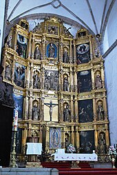
 Main altar from the 16th century at the San Bernardino Church
Pre-Hispanic Xochimilco was an island connected to the mainland by three causeways. One of these still exists in the form of Avenida Guadalupe I.Ramirez, one of the city's main streets. This causeway led to the main ceremonial center of the town, which was called the Quilaztli. The Spanish destroyed the Quilaztli during the Conquest, and replaced it with the San Bernardino de Siena Church, which would become the social and political center of the colonial city.[8] The city in turn, was the most important settlement in the south of the Valley of Mexico in the colonial era.[9] It became a settlement of Spanish, criollos and mestizos, with the indigenous living in rural communities outside of the city proper.[1]
During the Siege of Tenochtitlan, Hernán Cortés attacked the city and the "great number of warriors" in it. During the battle, Cortes was knocked from his horse, and almost captured by the Mexicans. The following day, Guatemoc sent ten thousand warriors by land and two thousand by canoe to attack the Spaniards, followed by ten thousand reinforcements. The Mexicans were defeated, and Cortes was able to capture five Mexican captains. Cortes then proceeded with his march.[10]: 340–347
After the Conquest, Apochquiyauhtzin, the last lord of Xochimilco, was baptized with the name of Luís Cortés Cerón de Alvarado in 1522 and he was allowed to continue governing under the Spanish. Evangelization was undertaken here by Martín de Valencia with a number of others who are known as the first twelve Franciscans in Mexico. Their monastery was built between 1534 and 1579, along with many chapels and churches in the Xochimilco area, a hospital in Tlacoapa and a school. Xochimilco was made an encomienda of Pedro de Alvarado in 1521 and remained such until 1541.[3]
The Spanish used the lakes and canals of the Valley of Mexico much as the indigenous did, at least at first.[5] Xochimilco remained an important agricultural area, shipping its produce to Mexico City in the same ways.[6] However, problems with flooding, especially the Great Flood of 1609 in Mexico City and Xochimilco, spurred the Spanish to begin projects to drain the lakes.[3][11] As a result, these lakes, including Lake Xochimilco, has suffered one of the most radical transformations in the history of urbanization. Five hundred years ago, the lake extended 350 km2 (140 sq mi) and contained 170 km2 (66 sq mi) of chinampas and 750 km (470 mi) of canals. Today, there are only 25 km2 (9.7 sq mi) of chinampas and 170 km (110 mi) of canals, and they are still disappearing.[5]
Xochimilco was granted the title of city by Felipe II in 1559. Through much of the colonial era, the city's native population was decimated by epidemics, especially typhoid. Despite this, and because of the apparent acceptance of Christianity, the Xochimilcas were permitted to retain a number of their traditions and their identity as a people. The area remained mostly indigenous for much of the colonial period. Its importance as an agricultural center with easy access to Mexico City meant that in the 17th century, about two thousand barges a day still traveled on the waters that separated the two areas.[3]
In 1749, Xochimilco became a "corregimiento" or semi-autonomous area from Mexico City and would remain so until Independence. It would also increase in importance as a stopover for those traveling between Mexico City and Cuernavaca. Also during this time, Xochimila Martín de la Cruz, wrote Xihuipahtli mecéhual amato, better known as the Aztec Herbal Book or the Cruz-Badiano Codex. It is the oldest book on medicine written on the American continent. It was translated into Latin by Juan Badiano. The original is in the Vatican.[3]
After Independence, Xochimilco became a municipality in what was then the State of Mexico. It would later become a part of the Federal District of Mexico City after the Mexican–American War, when this district was expanded.[3]
Manuel Payno in his novel "Los bandidos del río Frio" related a journey through here between San Lázaro and Chalco.[5] In 1850, the first steam-powered boat traveled through here, connecting Mexico City with Chalco. Steam powered ships remained in Xochimilco waters from then until the 1880s, when they faded from use. Before, during and after, Xochimilco continued to make more traditional rafts, canoes and trajineras, pushed along the shallow waters by a pole.[3]
Up through the centuries, the valley lakes continued to shrink but there were still canals that linked Xochimilco to the center of Mexico City. In the late 19th century, Mexico City had outgrown its traditional water supplies and began to take water from the springs and underground aquifers of Xochimilco.[3][12] Degradation of the lakes was fastest in the early 20th century, when projects such as the Canal del Desagüe were built to further drain the valley.[5] This and excessive aquifer pumping lowered water tables and canals near Mexico City center dried up and cut off an inexpensive way to get goods to market for Xochimilco.[3] This had a major effect on the area's economy, along with the effects of the loss of fishing for communities such as Santa Cruz Acalpixca, San Gregorio Atlapulco and San Luis Tlaxialtemalco.(rescartarlo)[3] In 1908, an electric tram serves was inaugurated that was supposed to reach Tulyehualco, but never did.[3]
During the Mexican Revolution, the first Zapatistas came into the borough through Milpa Alta. They burned areas in Nativitas and San Lucas in 1911 and then stayed without further attacks. They then took the city of Xochimilco in 1912, burning the southern part. The Zapatistas then controlled most of what is now the borough. On 23 April 1913, 39 youths were shot to death in a small alley in San Lucas Xochimanca. A plaque commemorates the site. When the Zapatistas were confronted by troops loyal to Venustiano Carranza in Cuemanco, they damaged pumps and set the center of Xochimilco and the original municipal palace on fire. In 1914, Francisco Villa and Emiliano Zapata met in San Gregorio and signed an alliance called the Pact of Xochimilco.[3]
After the war, Xochimilco became a borough when the Federal District was reorganized, including the communities of Mixquic, San Juan Ixtayopan and Tetelco. These and other territories would be lost and its final dimensions attained in 1931.[3]
In the 1920s, Xochimilco lost control of most of its water supply, taken by the city for its needs.[13] The urban sprawl of Mexico City reached Xochimilco in the mid 20th century and it still affects the borough today.[6] In the 1970s, the federal government began to replace the lost supply to the canals with treated water from the nearby Cerro de la Estrella. This is most of the water that now flows in the canals. The treated water is clear, but not potable due to bacteria and heavy metals. However, it is used to irrigate crops grown on the chinampas, even though the canals are further polluted by untreated sewage and garbage.[13] The biggest threat to the canals and their ecosystem is uncontrolled sprawl, mostly due to illegal building on conservation land. These settlements are polluting canals with untreated garbage and waste, and filling in canals to make "new land."[11] There are thirty-one illegal settlements in the historic center, with 2,700 constructions. Ten of these are in the chinampas of San Gregorio Atlapulco, San Luis Tlaxialtemalco, Santa Cruz Acalpixca, and Santa María Nativitas.[14] The borough and UNESCO are at odds over what to do about the 450 hectares of illegal settlements.[15] UNESCO demands their eviction, but the borough says this would be too difficult and better to legalize the settlements, putting efforts into preventing more.[11][15]


Add new comment