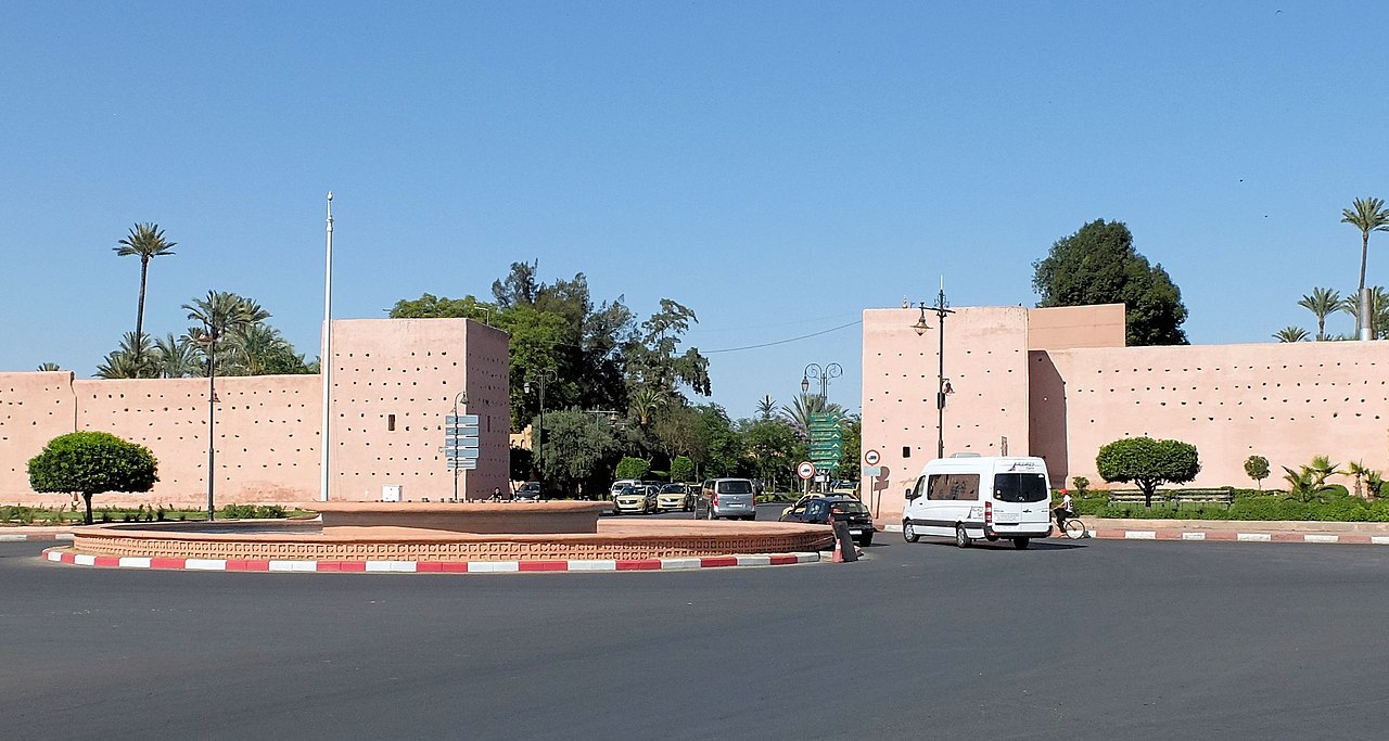
أسوار مراكش

( Walls of Marrakesh )

The Walls of Marrakesh are a set of defensive ramparts which enclose the historic medina districts of Marrakesh, Morocco. They were first laid out in the early 12th century by the Almoravid dynasty which founded the city in 1070 CE as their new capital. The walls have since been expanded several times by the addition of the Kasbah to the south at the end of the 12th century and by a later extension to encompass the northern neighbourhood around the Zawiya of Sidi Bel Abbes.

The Gates of Marrakesh were for the most part established since the original Almoravid construction of the city walls but most have been modified during later periods. Other gates were also added when the Almohads created the Kasbah, which itself has been expanded and re-worked many times since.

 Outline of the walls of Marrakesh today and their various historical components Almoravid foundation (11th-12th centuries)  The eastern walls of the city, near Bab Debbagh

Marrakesh was founded in 1070 by Abu Bakr ibn Umar, the early leader of the Almoravids.[1][2] At first, the city's only major fortification was the Ksar al-Hajjar ("Palace/Fortress of Stone"), a royal citadel built by Abu Bakr to protect the treasury.[1][2] It was located right next to the site of the current Kutubiyya Mosque in the western part of the city. Like other kasbahs of its time, it probably occupied a quadrangular area and is assumed to have had multiple gates (of which the western gate may have roughly corresponded to the later Bab al-Makhzen gate in the city walls).[1] Excavations in the 20th-century revealed that the citadel's southern side was 218 metres long, indicating a fairly large structure.[1]: 57  It was the first monumental structure built by the Almoravids and marked their definitive transition from a nomadic Saharan people to an empire with a fixed base.[1]

It was only in 1126 that Ali ibn Yusuf, a later Almoravid amir, decided to surround the city with a full circuit of walls, which were completed in January or February 1127.[1]: 110 [2]: 224  The decision to fortify the city with ramparts was likely due to rising threat of the Almohads at the time.[2] Abu-l-Walid ibn Rushd, a qadi from Cordoba and the grandfather of the famous Ibn Rushd (Averroes), was reportedly the one who convinced the amir to undertake the construction. Historical sources also claim that construction took only 8 months and cost 70,000 gold dinars.[1]: 108–109  Prior to construction, the path of the walls was laid out with ropes and the amir's astrologers were consulted for the most propitious date on which to start.[1]

The main outline of the medina's walls today is still broadly that of the original Almoravid walls, although with notable differences to the north and south. The resulting walled area formed an irregular polygon of vaguely quadrangular shape.[2][1] Some of the irregularities in this outline may have been due to existing cemeteries and religious sites or to last-minute decisions to include more land within the walls.[1] Many of the city's main gates also date back to this period — at least in their locations if not necessarily in their current forms and names. These gates were, in clockwise order starting from the northeast: Bab Fes (later known as Bab el-Khemis), Bab Debbagh, Bab Aylan, Bab Aghmat, Bab Yintan, Bab as-Saliha, Bab Neffis (probably the predecessor of Bab er-Robb today), Bab ash-Shari'a, Bab al-Makhzen, Bab el-'Arissa (also known as Bab ar-Raha), Bab Doukkala, Bab Moussoufa, and Bab Taghzout.[3][1]: 118–128 [2] Four of these gates — Bab ash-Shari'a, Bab Moussoufa, Bab Yintan, and Bab as-Saliha — disappeared some time ago and are only known from historical texts or from vestigial physical evidence.[1][3]

Almohad period (late 12th to 13th centuries)  The outer walls of the kasbah, south of Bab Agnaou

When the Almohad ruler Abd al-Mu'min conquered Marrakesh in 1147 he reportedly destroyed many Almoravid monuments (especially mosques) but the Ksar el-Hajjar and the palace of Ali ibn Yusuf were still used as the official residence of the new Almohad rulers for a time.[1][2] The Almohad caliph Ya'qub al-Mansur (ruled 1184-1199), however, embarked on an ambitious construction project to create a vast new royal district, the Kasbah, attached to the south side of the city. Its creation was motivated in part by the rapid growth of the city's population and an urgent need for more space within the city.[4] However it may also have been motivated by the Almohad caliph's desire to follow the example of other powerful Islamic rulers who built separate palace-cities from which to rule, such as the Ummayyad construction of Madinat al-Zahra near Cordoba or the Abbasid construction of Samarra in Iraq.[1] Construction of the kasbah began in 1185 and finished by 1190.[1][2][4]

The current western and southern outline of the kasbah today, including its walls, most likely still date back essentially to the Almohad construction.[1]: 214  The kasbah's main gate was Bab Agnaou: both a defensive and a ceremonial gateway, located just inside the city walls near Bab er-Robb (Bab Neffis) and forming the main public access to the kasbah for the city's residents.[5][3][4] The Almohads also established vast gardens and orchards near the kasbah, in particular the al-Buhayra garden now known as the Agdal Gardens. These were located further and were enclosed by their own separate walls.[2][1][6][7]

The Saadian and Alaouite periods (15th century and after)  The Sqallat al-Mrabit, a 19th-century fort built by Sultan Muhammad ibn Abd al-Rahman to protect the western flank of the Agdal Gardens

Following the demise of the Almohad regime, Marrakesh as a whole fell into decline. The following Marinid dynasty made Fes their capital and carried out few major constructions in Marrakesh. It wasn't until the Saadian Dynasty (16th century to early 17th century) established Marrakesh as their capital that the city saw a resurgence.[1][8] The Saadians renovated the kasbah and expanded its northern outline slightly with new palaces such as El Badi. Sultan Moulay Abdallah al-Ghalib also transferred the Jewish population of the city to a new Mellah district on the east side of the Royal Palace, expanding the eastern outline of the kasbah in the process.[1][8] Sultan Ahmad al-Mansur also renovated and replanted the Agdal Gardens, thus maintaining this large walled enclosure to the south of the city.[8]

The Saadians, and their successors the Alaouites, also sponsored the construction and expansion of the zawiya and mosque complex around the mausoleum of Sidi Bel Abbes, which was located just outside the northern gate of the city, Bab Taghzout. Sidi Bel Abbes is often considered the patron saint of Marrakesh[9] and his zawiya attracted more and more settlers to the area until a flourishing neighbourhood developed here outside the walls of the city. In the 18th century, under the reign of the Alaouite sultan Muhammad ibn Abdallah, the walls of the city were finally extended to encompass this neighbourhood, forming the new northern point of the city.[1][2] In the same period, the sultan also extended the Kasbah southwards and extended the Agdal northwards, until the walls of both enclosures were joined together.[10][11][1] This constituted the last major extension and modification of the city walls.

 Medina walls of Marrakesh in a photo of 1925. ETH Library.

Other works by Alaouite sultans still added to the existing walls and gates of the city. Sultan Muhammad ibn Abdallah is also responsible for much of the construction and redevelopment of the royal palace (Dar al-Makhzen) following years of neglect, giving it more or less its present-day form.[1] The southern side of the Kasbah was expanded to accommodate new gardens, new neighbourhoods for palace servants and troops, and a series of walled squares known as mechouars (an official square/courtyard at the entrance of a royal palace). A multitude of gates were built to regulate passage between these new southern annexes. Many of them are of minor architectural interest, though Bab Ahmar (the easternmost gate) has a unique design that includes an elevated platform for light artillery.[1] Lastly, following its destruction by the Rehamna in 1862, the western wall of the Agdal Gardens was rebuilt by Sultan Muhammad ibn Abd al-Rahman. At the same time, the sultan added a fort called Sqallat al-Mrabit to defend this part of the ramparts.[1]: 529 

2023 earthquake

Following the 2023 Marrakesh-Safi earthquake on 8 September, portions of the city walls collapsed.[12]

^ a b c d e f g h i j k l m n o p q r s t u v w x Deverdun, Gaston (1959). Marrakech: Des origines à 1912. Rabat: Éditions Techniques Nord-Africaines. ^ a b c d e f g h i j Wilbaux, Quentin (2001). La médina de Marrakech: Formation des espaces urbains d'une ancienne capitale du Maroc. Paris: L'Harmattan. ISBN 2747523888. ^ a b c Allain, Charles; Deverdun, Gaston (1957). "Les portes anciennes de Marrakech". Hespéris. 44: 85–126. ^ a b c Bennison, Amira K. (2016). The Almoravid and Almohad Empires. Edinburgh University Press. ^ Lintz, Yannick; Déléry, Claire; Tuil Leonetti, Bulle (2014). Maroc médiéval: Un empire de l'Afrique à l'Espagne. Paris: Louvre éditions. ISBN 9782350314907. ^ Navarro, Julio; Garrido, Fidel; Almela, Íñigo (2017). "The Agdal of Marrakesh (Twelfth to Twentieth Centuries): An Agricultural Space for Caliphs and Sultans. Part 1: History". Muqarnas. 34 (1): 23–42. doi:10.1163/22118993_03401P003. ^ Navarro, Julio; Garrido, Fidel; Almela, Íñigo (2018). "The Agdal of Marrakesh (Twelfth to Twentieth Centuries): An Agricultural Space for Caliphs and Sultans. Part II: Hydraulics, Architecture, and Agriculture". Muqarnas. 35 (1): 1–64. doi:10.1163/22118993_03501P003. S2CID 116253890. ^ a b c Salmon, Xavier (2016). Marrakech: Splendeurs saadiennes: 1550-1650. Paris: LienArt. ISBN 9782359061826. ^ "Marrakush". The Encyclopedia of Islam. Vol. 6. E. J. Brill. January 1989. p. 591. ISBN 9789004090828. ^ Navarro, Julio; Garrido, Fidel; Almela, Íñigo (2017). "The Agdal of Marrakesh (Twelfth to Twentieth Centuries): An Agricultural Space for Caliphs and Sultans. Part 1: History". Muqarnas. 34 (1): 23–42. doi:10.1163/22118993_03401P003. ^ Navarro, Julio; Garrido, Fidel; Almela, Íñigo (2018). "The Agdal of Marrakesh (Twelfth to Twentieth Centuries): An Agricultural Space for Caliphs and Sultans. Part II: Hydraulics, Architecture, and Agriculture". Muqarnas. 35 (1): 1–64. doi:10.1163/22118993_03501P003. S2CID 116253890. ^ "انهيار مباني بينها صومعة مسجد في مراكش إثر الهزة الأرضية (صور)" [Buildings collapse, including the minaret of a mosque, in Marrakesh following the earthquake (photos)] (in Arabic). Alyaoum24. 9 September 2023. Archived from the original on 9 September 2023. Retrieved 9 September 2023.
Photographies by:
Antony Stanley from Gloucester, UK - CC BY-SA 2.0
Statistics: Position
5696
Statistics: Rank
15315

Add new comment

Esta pregunta es para comprobar si usted es un visitante humano y prevenir envíos de spam automatizado.

Security
951247683Click/tap this sequence: 1833

Google street view

Where can you sleep near Walls of Marrakesh ?

Booking.com
489.284 visits in total, 9.196 Points of interest, 404 Destinations, 111 visits today.