St Michael's Mount

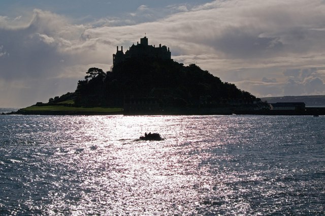
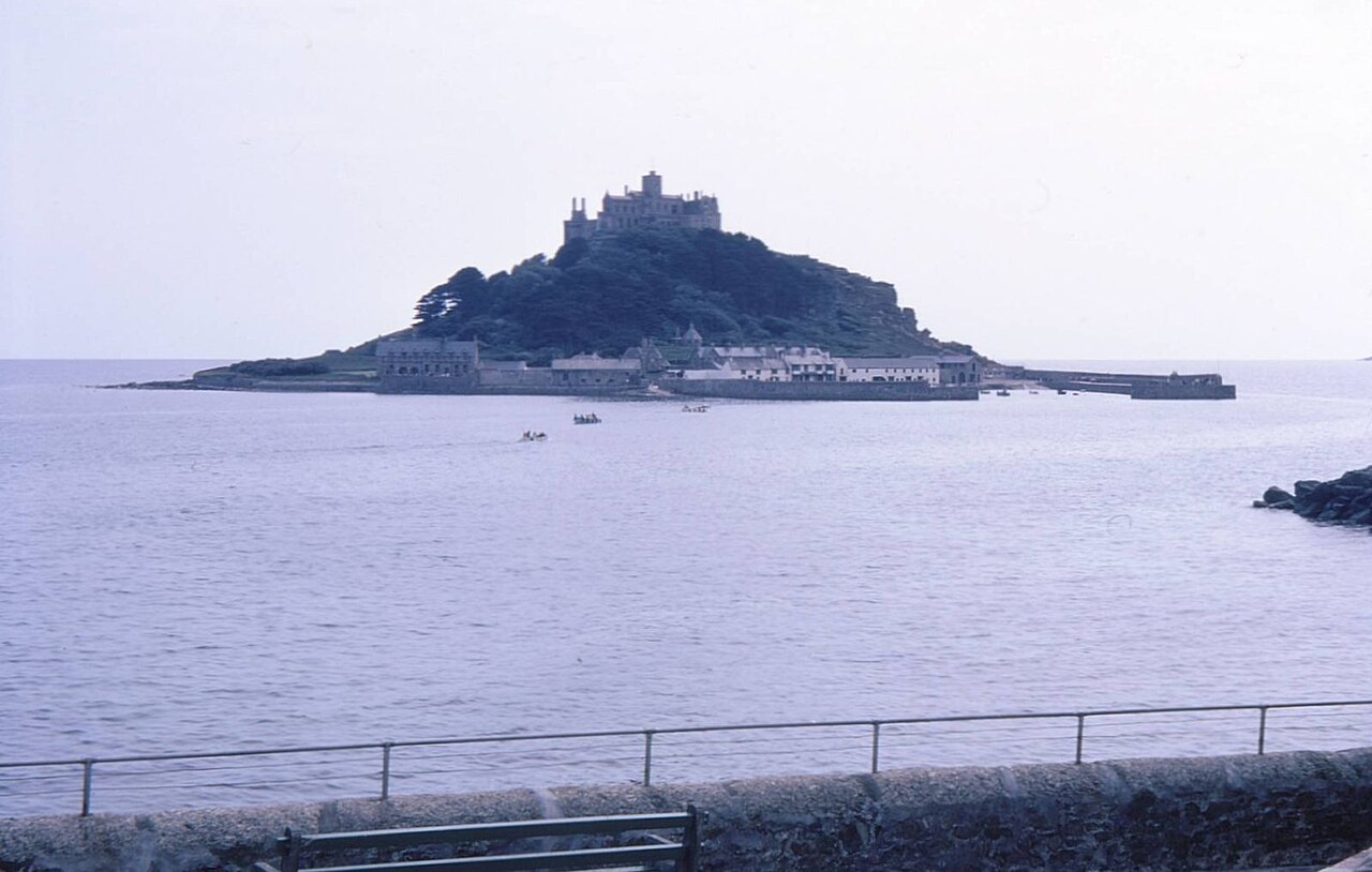
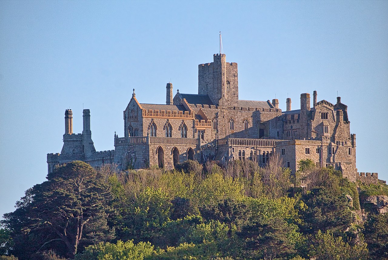
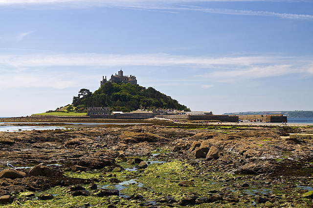
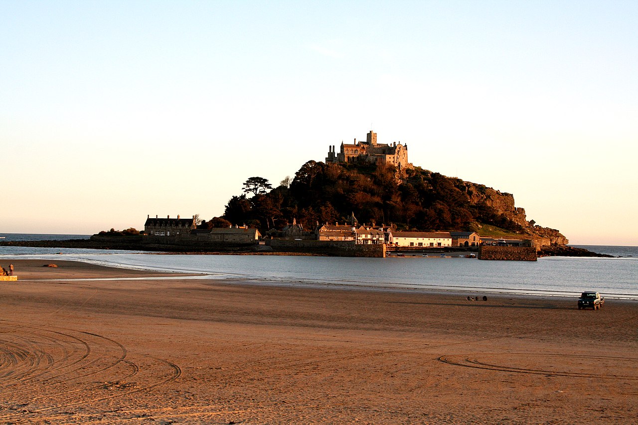
St Michael's Mount (Cornish: Karrek Loos yn Koos, meaning "hoar rock in woodland") is a tidal island in Mount's Bay, Cornwall, England, United Kingdom. The island is a civil parish and is linked to the town of Marazion by a causeway of granite setts, passable (as is the beach) between mid-tide and low water. It is managed by the National Trust, and the castle and chapel have been the home of the St Aubyn family since around 1650.

Historically, St Michael's Mount was an English counterpart of Mont-Saint-Michel in Normandy, France, which is also a tidal island, and has a similar conical shape, though Mont-Saint-Michel is much taller.

St Michael's Mount is one of 43 unbridged tidal islands to which you can walk from mainland Britain. Part of the island was designated as a Site of Special Scientific Interest in 1995 for its geology. Sea height can vary by up to around 5 metres between low and high tide.

 St Michael's Mount in 1900 St Michael's Mount (postcard c. 1920) by A. R. Quinton

St Michael's Mount may have been the site of a monastery from the 8th to the early 11th centuries. Edward the Confessor gave the site to the Benedictine order of Mont-Saint-Michel[1][2] and it was a priory of that abbey until the dissolution of the alien houses as a side-effect of the war in France by Henry V. Subsequently, it ceased to be a priory, but was reduced to being a secular chapel which was given to the Abbess and Convent of Syon at Isleworth, Middlesex, in 1424.[3] Thus ended its association with Mont-Saint-Michel,[1][4] and any connection with Looe Island (dedicated to the Archangel Michael). It was a destination for pilgrims, whose devotions were encouraged by an indulgence granted by Pope Gregory in the 11th century.[5] The earliest buildings on the summit, including a castle, date to the 12th century.[6][7]

Siege, occupation and ownership

Sir Henry de la Pomeroy captured the Mount in 1193, on behalf of Prince John, in the reign of King Richard I,[8] the leader of the previous occupants having 'died of fright' upon learning rumours of Richard's release from captivity.[9] The monastic buildings were built during the 12th century. Various sources state that the earthquake of 1275 destroyed the original Priory Church,[10] although this may be a misunderstanding of the term "St Michael's on the Mount" which referred to the church of St Michael atop Glastonbury Tor.[11] Syon Abbey, a monastery of the Bridgettine Order, acquired the Mount in 1424.[12] Some 20 years later the Mount was granted by Henry VI to King's College, Cambridge on its foundation.[13] However, when Edward IV took the throne during the Wars of the Roses the Mount was returned to the Syon Abbey in 1462.[13][14]

John de Vere, 13th Earl of Oxford, seized and held it during a siege of 23 weeks against 6,000 of Edward IV's troops in 1473–74. Perkin Warbeck, a pretender to the English throne, occupied the Mount in 1497. Sir Humphrey Arundell, Governor of St Michael's Mount, led the Prayer Book Rebellion of 1549. During the reign of Queen Elizabeth I, it was given to Robert Cecil, Earl of Salisbury, by whose son it was sold to Sir Francis Bassett. During the Civil War, Sir Arthur Bassett, brother of Sir Francis, held the Mount against the Parliament until July 1646.[5]

The Mount was sold in 1659 to Colonel John St Aubyn.[5] As of 2021[update] his descendants, the Lords St Levan, remain seated at St Michael's Mount.

18th century

Little is known about the village before the beginning of the 18th century, save that there were a few fishermen's cottages and monastic cottages. After improvements to the harbour in 1727, St Michael's Mount became a flourishing seaport.

In 1755, the Lisbon earthquake caused a tsunami to strike the Cornish coast over 1,000 miles (1,600 km) away. The sea rose six feet (2 m) in 10 minutes at St Michael's Mount, ebbed at the same rate, and continued to rise and fall for five hours. The 19th-century French writer Arnold Boscowitz claimed that "great loss of life and property occurred upon the coasts of Cornwall."[15]

19th century  An 1890s painting by James Webb

By 1811, there were 53 houses and four streets. The pier was extended in 1821[16] and the population peaked in the same year, when the island had 221 people. There were three schools, a Wesleyan chapel, and three public houses, mostly used by visiting sailors. Following major improvements to nearby Penzance harbour, and the extension of the railway to Penzance in 1852, the village went into decline, and many of the houses and other buildings were demolished.

During the 18th and 19th centuries, the structure of the castle was romanticised.[7] In the late 19th century, the remains of an anchorite were discovered in a tomb within the domestic chapel.[17]

A short, underground narrow gauge railway was constructed in about 1900. It was used to bring goods up to the castle and take away rubbish. In 2018, the tramway was reported as being "still in regular use, perhaps not every day",[18] and is not open to the general public, although a small stretch is visible at the harbour. It is Britain's last functionally operational 4 ft 6 in (1,372 mm) railway.[19][20]

Some sources, including in the British industrial narrow gauge railways, a list of track gauges and, in 2018, on an information board near the line, suggest a different gauge of 2 ft 5 in (737 mm) [21] while The Railway Magazine says it has a gauge of 2 ft 5+12 in (750 mm). [22]

Second World War

The Mount was fortified in World War II, during the invasion crisis of 1940–41. Three pillboxes can be seen to this day.[23] After the war, the decommissioned battleship HMS Warspite was beached near the mount, and was scrapped in place after attempts to refloat the wreck failed.

Sixty-five years after the Second World War, it was suggested based on interviews with contemporaries that the former Nazi Foreign Minister and one-time ambassador to London, Joachim von Ribbentrop, had intended to live at the mount after the planned German conquest. Archived documents revealed that during his time in Britain in the 1930s, when he had proposed an alliance with Nazi Germany, von Ribbentrop frequently visited Cornwall.[24]

National Trust

In 1954, Francis Cecil St Aubyn, 3rd Baron St Levan, gave most of St Michael's Mount to the National Trust, together with a large endowment fund. The St Aubyn family retained a 999-year lease to inhabit the castle and a licence to manage the public viewing of its historic rooms. This is managed in conjunction with the National Trust.[citation needed]

^ a b Nikolaus Pevsner, Enid Radcliffe (1970). Cornwall. Yale University Press. pp. 193–195. ISBN 9780140710014. ^ Henderson, Charles (1925). Cornish Church Guide. Truro: Oscar Blackford. pp. 160–61. ^ Fletcher, J. R. (Canon), Short History of Saint Michael's Mount, Published at St Michael's Mount 1951. ^ McCabe, Helen (1988). Houses and Gardens of Cornwall. Padstow: Tabb House. ISBN 978-0907018582. ^ a b c Cite error: The named reference EB1911 was invoked but never defined (see the help page). ^ Cite error: The named reference cas was invoked but never defined (see the help page). ^ a b "St Michael's Mount". CastlesFortsBattles.co.uk. Retrieved 23 July 2019. ^ Richard Carew (1811). Carew's Survey of Cornwall. T. Bensley. p. 379. ^ John Harvey (1948). The Plantagenets. B.T.Batsford Ltd. ^ Historic England. "THE CHURCH OF SAINT MICHAEL, St. Michael's Mount (1310728)". National Heritage List for England. Retrieved 6 August 2019. ^ Musson, RMW (2008). "The seismicity of the British Isles to 1600" (PDF). British Geological Survey (Earth Hazards and Systems): 37. Retrieved 6 August 2019. ^ Harry, Carlene. "Morvah - which St Bridget?". Penwith Local History Group. Retrieved 17 May 2018. ^ a b "St Buryan deanery and the Priory of St Michael's Mount", King’s College Estates Records, vol. KCAR/6/2/138, 13 May 2014 ^ J P C Roach (ed.). "The colleges and halls: King's'". A History of the County of Cambridge and the Isle of Ely: Volume 3, the City and University of Cambridge. ^ "Sources of Cornish History – The Lisbon Earthquake". Cornwall Council. 12 September 2011. Retrieved 16 September 2012. ^ "St Michael's Mount". New Monthly Magazine. May 1821. p. 259. Retrieved 27 December 2012. ^ "Things to know before Applying for Payday Advance Online – Cornwall OPC". Retrieved 13 June 2020. ^ Sunders, Charlie (September 2018). Bennett, Paul (ed.). "Drecky Express (Visit report)". Narrow Gauge News. Narrow Gauge Railway Society (348). ^ "St Michaels Mount, Cornish Cliff Railway". Hows Website. Archived from the original on 5 November 2016. Retrieved 28 September 2016. ^ "St Michael's Mount Cliff Railway". South Western Historical Society. Retrieved 28 September 2016. ^ Dart, Maurice (2005). Cornwall Narrow Gauge including the Camborne & Redruth tramway. Midhurst: Middleton Press. ISBN 978-1-904474-56-2. ^ Semmens, Peter W. C. (July 1964). Cooke, B.W.C. (ed.). "St Michael's Mount Tramway". The Railway Magazine. London: Tothill Press Limited. 110 (759): 585. ISSN 0033-8923. ^ Foot, William (2006). Beaches, fields, streets, and hills ... the anti-invasion landscapes of England, 1940. Council for British Archaeology. pp. 88–93. ISBN 978-1-902771-53-3. ^ Vanessa Thorpe (3 October 2010). "Nazi foreign minister planned to own Cornwall as his retirement home". The Observer. Retrieved 16 September 2012.
Photographies by:
Statistics: Position
1655
Statistics: Rank
74533

Add new comment

Esta pregunta es para comprobar si usted es un visitante humano y prevenir envíos de spam automatizado.

Security
142963758Click/tap this sequence: 8896

Google street view

Where can you sleep near St Michael's Mount ?

Booking.com
489.759 visits in total, 9.196 Points of interest, 404 Destinations, 10 visits today.