خارطة مادبا

( Madaba Map )

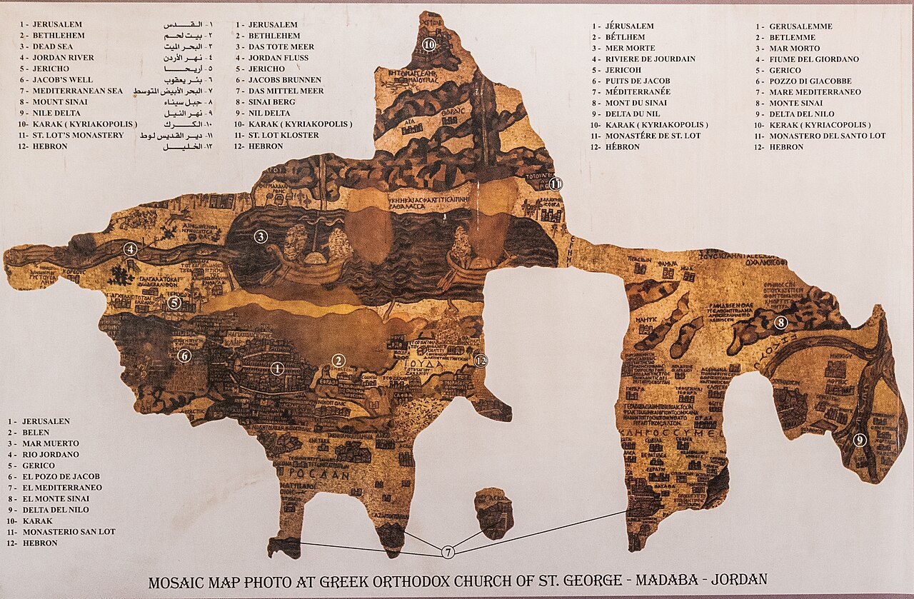
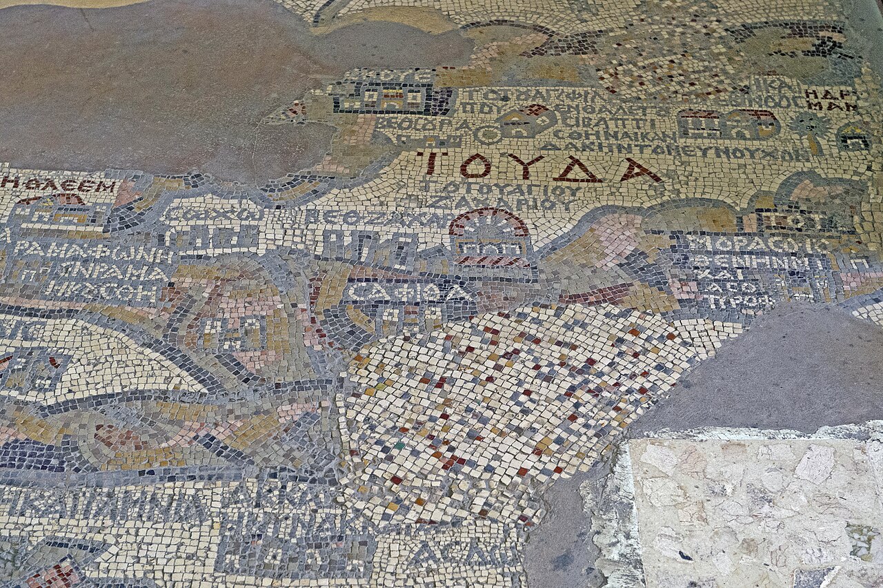
The Madaba Map, also known as the Madaba Mosaic Map, is part of a floor mosaic in the early Byzantine church of Saint George in Madaba, Jordan.

The mosaic map depicts an area from Lebanon in the north to the Nile Delta in the south, and from the Mediterranean Sea in the west to the Eastern Desert.

It contains the oldest surviving original cartographic depiction of the Holy Land and especially Jerusalem. The map dates to the sixth century AD.

 Annotated reproduction of the Madaba Map (19k×12.5k pixels)

The Madaba Mosaic Map depicts Jerusalem with the New Church of the Theotokos, which was dedicated on 20 November 542. Buildings erected in Jerusalem after 570 are absent from the depiction, thus limiting the date range of its creation to the period between 542 and 570.[1] The mosaic was made by unknown artists, probably for the Christian community of Madaba, which was the seat of a bishop at that time.

In 614, Madaba was conquered by the Sasanian Empire. In the eighth century, the ruling Muslim Umayyad Caliphate had some figural motifs removed from the mosaic. In 746, Madaba was largely destroyed by an earthquake and subsequently abandoned.

 The newly rediscovered mosaic inside the modern Orthodox church

Elements of the inscribed mosaic were noticed and reported to the Jerusalem Patriarchate in 1884 and 1886, during the preparation work for the construction of a new Greek Orthodox church on the site of its ancient predecessor.[2] Patriarch Nicodemus I of Jerusalem was informed, the church building erected and roofed over (summer 1895-August 1896), but the full mosaic was only noticed during clearing work for a new cement-slab floor in October 1896, and no research was carried out until December of that year, after the floor had already been laid around the mosaic by local workers under the supervision of a Greek architect.[2][3][4]

In the following decades, large portions of the mosaic map were damaged by fires, activities in the new church, and by the effects of moisture. In December 1964, the Volkswagen Foundation gave the Deutscher Verein zur Erforschung Palästinas (lit. "German Association for the Exploration of Palestine") 90,000 DM to save the mosaic. In 1965, the archaeologists Heinz Cüppers and Heinrich Brandt undertook the restoration and conservation of the remaining parts of the mosaic.[5]

^ Keyser, Paul T.; Scarborough, John (2018). The Oxford Handbook of Science and Medicine in the Classical World. Oxford: Oxford UP. p. 937. ISBN 978-0-19-973414-6. Retrieved 21 February 2022. ^ a b Meimaris, Yiannis (1999). Eugenio Alliata; Michele Piccirillo (eds.). "The Discovery of the Madaba Mosaic Map. Mythology and Reality: The Madaba Map Centenary. 1897-1997. Travelling through the Byzantine Umayyad Period". Collectio Maior (40). Jerusalem: Franciscan Printing Press. pp. 25–36. Archived from the original on 3 October 2013. Retrieved 9 June 2011 – via ChristusRex.org (Franciscan Cyberspot), 2000 webpage expanding on 1999 book. ^ Donner, 1992, p.11 ^ Piccirillo, Michele (21 September 1995). "A Centenary to be celebrated". Jordan Times. Franciscan Archaeology Institute. Retrieved 18 January 2019. It was only Abuna Kleofas Kikilides who realised the true significance, for the history of the region, that the map had while visiting Madaba in December 1896. A Franciscan friar of ltalian-Croatian origin born in Constantinople, Fr. Girolamo Golubovich, helped Abuna Kleofas to print a booklet in Greek about the map at the Franciscan printing press of Jerusalem. Immediately afterwards, the Revue Biblique published a long and detailed historic-geographic study of the map by the Dominican fathers M.J. Lagrange and H. Vincent after visiting the site themselves. At the same time. Father J. Germer-Durand of the Assumptionist Fathers published a photographic album with his own pictures of the map. In Paris, C. Clermont-Ganneau, a well known oriental scholar, announced the discovery at the Academie des Sciences et belles Lettres. ^ Donner, Herbert (1992). The Mosaic Map of Madaba: An Introductory Guide. Kampen: Pharos. p. 12. ISBN 978-90-390-0011-3. Retrieved 21 February 2022.
Photographies by:
David Bjorgen - CC BY-SA 2.5
Zones
Statistics: Position
851
Statistics: Rank
125583

Add new comment

Esta pregunta es para comprobar si usted es un visitante humano y prevenir envíos de spam automatizado.

Security
673529841Click/tap this sequence: 8811

Google street view

Videos

Where can you sleep near Madaba Map ?

Booking.com
487.386 visits in total, 9.187 Points of interest, 404 Destinations, 12 visits today.