Machu Picchu
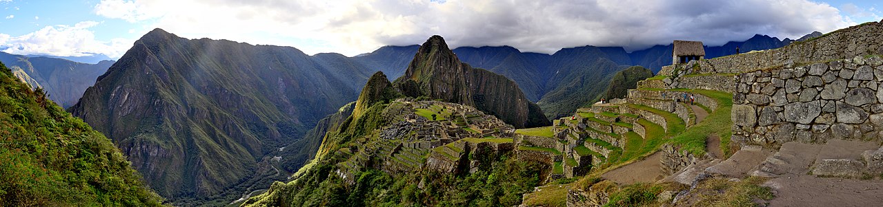
Machu Picchu is a 15th-century Inca citadel located in the Eastern Cordillera of southern Peru on a mountain ridge at 2,430 meters (7,970 ft). Often referred to as the "Lost City of the Incas", it is the most familiar icon of the Inca Empire. It is located in the Machupicchu District within the Urubamba Province above the Sacred Valley, which is 80 kilometers (50 mi) northwest of the city of Cusco. The Urubamba River flows past it, cutting through the Cordillera and creating a canyon with a subtropical mountain climate.
The Inca civilization had no written language and following the first encounter by the Spanish soldier Baltasar Ocampo, no Europeans are recorded to have visited the site from the late 16th century until the 19th century. As far as historical knowledge extends, there are no existing written records detailing the site during its period of active use. The leading theory is that Machu Picchu was a private city for Incan r...Read more
Machu Picchu is a 15th-century Inca citadel located in the Eastern Cordillera of southern Peru on a mountain ridge at 2,430 meters (7,970 ft). Often referred to as the "Lost City of the Incas", it is the most familiar icon of the Inca Empire. It is located in the Machupicchu District within the Urubamba Province above the Sacred Valley, which is 80 kilometers (50 mi) northwest of the city of Cusco. The Urubamba River flows past it, cutting through the Cordillera and creating a canyon with a subtropical mountain climate.
The Inca civilization had no written language and following the first encounter by the Spanish soldier Baltasar Ocampo, no Europeans are recorded to have visited the site from the late 16th century until the 19th century. As far as historical knowledge extends, there are no existing written records detailing the site during its period of active use. The leading theory is that Machu Picchu was a private city for Incan royalty. The names of the buildings, their supposed uses, and their inhabitants, are the product of modern archaeologists based on physical evidence, including tombs at the site. Machu Picchu was built in the classical Inca style, with polished dry-stone walls. Its three primary structures are the Temple of the Sun, the Temple of the Three Windows, and the Intihuatana. From 1929 to 1971, Machu Picchu underwent extensive restoration and conservation work, including structural stabilization and artifact excavation, driven by government initiatives and research expeditions. Most recent archaeologists believe that Machu Picchu was constructed as an estate for the Inca emperor Pachacuti (1438–1472). The Inca built the estate around 1450 but abandoned it a century later, at the time of the Spanish conquest. According to the new AMS radiocarbon dating, it was occupied from c. 1420–1532. Historical research published in 2022 claims that the site was probably called Huayna Picchu by the Inca people themselves, as it exists on the smaller peak of the same name.
Machu Picchu was declared a Peruvian Historic Sanctuary in 1982 and a UNESCO World Heritage Site in 1983. In 2007, Machu Picchu was voted one of the New Seven Wonders of the World in a worldwide internet poll.


 - Public domain")


. - Public domain")


![[node:title]](/sites/default/files/styles/640x320/public/default_images/default_0.JPG.webp?itok=aqV9zhFR)


 from New York City, USA - CC BY-SA 2.0")


Add new comment