Heron Island (Queensland)
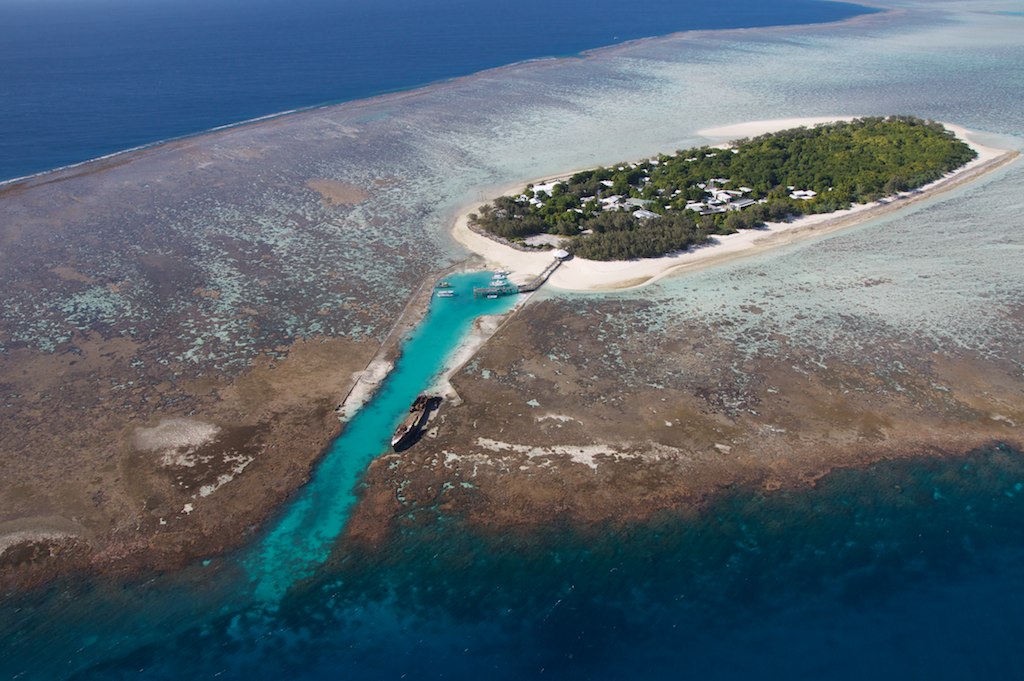
Heron Island is a coral cay located near the Tropic of Capricorn in the southern Great Barrier Reef. It is 87 kilometres (54 miles) north-east of Gladstone, Queensland, Australia, and 460 km (290 mi) north-north-west of the state capital Brisbane. The island is situated on the leeward (western) side of Heron Reef, a fringing platform reef of significant biodiversity, supporting around 900 of the 1,500 fish species and 72% of the coral species found on the Great Barrier Reef. During the summer months Heron Island is also home to over 200,000 birds including Noddy Terns and Mutton Birds.
The island is about 800 metres (2,600 feet) long and 300 metres (980 ft) at its widest, giving an area of approximately 16 hectares (40 acres). The highest point, near the western tip, is 3.6 metres (12 ft) above sea level. A dune ridge along the southern shore rises some 3 metres (9 ft 10 in) above sea level, lower dunes on the north-eastern side are only...Read more
Heron Island is a coral cay located near the Tropic of Capricorn in the southern Great Barrier Reef. It is 87 kilometres (54 miles) north-east of Gladstone, Queensland, Australia, and 460 km (290 mi) north-north-west of the state capital Brisbane. The island is situated on the leeward (western) side of Heron Reef, a fringing platform reef of significant biodiversity, supporting around 900 of the 1,500 fish species and 72% of the coral species found on the Great Barrier Reef. During the summer months Heron Island is also home to over 200,000 birds including Noddy Terns and Mutton Birds.
The island is about 800 metres (2,600 feet) long and 300 metres (980 ft) at its widest, giving an area of approximately 16 hectares (40 acres). The highest point, near the western tip, is 3.6 metres (12 ft) above sea level. A dune ridge along the southern shore rises some 3 metres (9 ft 10 in) above sea level, lower dunes on the north-eastern side are only about one metre (3 ft 3 in) above the sea.
Heron Island and an extrapolated version of the research station are the scene of much of the first part of Arthur C. Clarke's The Deep Range.


Add new comment