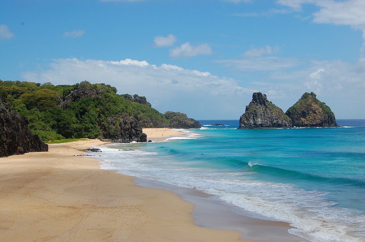
Fernando de Noronha

Fernando de Noronha (Portuguese pronunciation: [feʁˈnɐ̃du dʒi noˈɾoɲɐ]), officially the State District of Fernando de Noronha (Portuguese: Distrito Estadual de Fernando de Noronha) and formerly known as the Territory of Fernando de Noronha (Portuguese: Território de Fernando de Noronha) until 1988, is an archipelago in the Atlantic Ocean, part of the State of Pernambuco, Brazil, and located 354 km (191 nmi; 220 mi) off the Brazilian coast. It consists of 21 islands and islets, extending over an area of 26 km2 (10 sq mi). Only the eponymous main island is inhabited; it has an area of 18.4 km2 (7.1 sq mi) and a population estimated at 3,101 in 2020. While most of the archipelago is relatively low-lying, there are parts reaching more than 100 m (3...Read more

Fernando de Noronha (Portuguese pronunciation: [feʁˈnɐ̃du dʒi noˈɾoɲɐ]), officially the State District of Fernando de Noronha (Portuguese: Distrito Estadual de Fernando de Noronha) and formerly known as the Territory of Fernando de Noronha (Portuguese: Território de Fernando de Noronha) until 1988, is an archipelago in the Atlantic Ocean, part of the State of Pernambuco, Brazil, and located 354 km (191 nmi; 220 mi) off the Brazilian coast. It consists of 21 islands and islets, extending over an area of 26 km2 (10 sq mi). Only the eponymous main island is inhabited; it has an area of 18.4 km2 (7.1 sq mi) and a population estimated at 3,101 in 2020. While most of the archipelago is relatively low-lying, there are parts reaching more than 100 m (328 ft) in elevation.

The islands are administratively unique in Brazil. They form a "state district" (Portuguese: distrito estadual) that is administered directly by the government of the state of Pernambuco (despite being closer to the state of Rio Grande do Norte). The state district's jurisdiction also includes the very remote Saint Peter and Saint Paul Archipelago, located 625 km (337 nmi; 388 mi) northeast of Fernando de Noronha. Seventy percent of the islands' area was established in 1988 as a national marine park.

In 2001, UNESCO designated it as a World Heritage Site because of its importance as a feeding ground for tuna, sharks, turtles, and marine mammals. Its time zone is UTC−02:00 all year round.

Discovery  The main island Morro Dois Irmãos Satellite picture of Fernando de Noronha

Fernando de Noronha's occupation dates to the early 16th century. Due to its geographical position, the archipelago was one of the first lands sighted in the New World, being shown in a nautical chart in 1500 by the Spanish cartographer Juan de La Cosa, and in 1502 by the Portuguese Alberto Cantino, in the latter with the name "Quaresma".[1]

Based on the written record, Fernando de Noronha island was discovered on August 10, 1503, by a Portuguese expedition, organized and financed by a private commercial consortium headed by the Lisbon merchant Fernão de Loronha. The expedition was under the overall command of captain Gonçalo Coelho and carried the Italian adventurer Amerigo Vespucci aboard, who wrote an account of it.[2] The flagship of the expedition hit a reef and foundered near the island, "nothing being saved but the crew." On Coelho's orders, Vespucci anchored at the island, and spent a week there, while the rest of the Coelho fleet went on south. In his letter to Soderini, Vespucci describes the uninhabited island and reports its name as the "island of St. Lawrence" (August 10 is the feast day of St. Lawrence; it was a custom of Portuguese explorations to name locations by the liturgical calendar).[3]

Its existence was reported to Lisbon sometime between then and January 16, 1504, when King Manuel I of Portugal issued a charter granting the "island of St. John" (São João) as a hereditary captaincy to Fernão de Loronha.[4] The date and new name in the charter has presented historians with a puzzle. As Vespucci did not return to Lisbon until June, 1504, the discovery must have been earlier. Historians have hypothesized that a stray ship of the Coelho fleet, under an unknown captain, may have returned to the island (prob. on August 29, 1503, feast day of the beheading of St. John the Baptist) to collect Vespucci, did not find him or anyone else there, and went back to Lisbon by itself with the news.[5] (Vespucci in his letter, claims he left the island August 18, 1503, and upon his arrival in Lisbon a year later, on June 18, 1504, the people of Lisbon were surprised, as they "had been told" (presumably by the earlier captain?) that his ship had been lost.[6] The captain who returned to Lisbon with the news (and the St. John name) is unknown. Some have speculated this captain was Loronha himself, the chief financier of this expedition.

This account, reconstructed from the written record, is severely marred by the cartographic record. An island, named Quaresma, looking very much like Fernando de Noronha island, appears in the Cantino planisphere. The Cantino map was composed by an anonymous Portuguese cartographer, and completed before November 1502, well before the Coelho expedition even set out. This has led to speculation that the island was discovered by a previous expedition. However, there is no consensus on which expedition that might have been. The name "Quaresma" means Lent, suggesting it must have been discovered in March or early April, which does not correspond well with the known expeditions. There is also a mysterious red island to the left of Quaresma in the Cantino map that does not fit with Fernando de Noronha island. Some have explained these anomalies away by reading quaresma as anaresma (meaning unknown, but sidesteps the Lent timing),[7] and proposing that the red island is just an accidental inkblot.[8]

 Detail from the 1502 Cantino planisphere, showing the island of "Quaresma" (Fernando de Noronha?) off the Brazilian coast.

Assuming Quaresma is indeed Fernando de Noronha, then it's unknown who discovered it. One proposal is that it was discovered by a royal Portuguese mapping expedition that was sent out in May 1501, commanded by an unknown captain (possibly André Gonçalves) and also accompanied by Amerigo Vespucci.[9] According to Vespucci, this expedition returned to Lisbon in September 1502, just on time to influence the final composition of the Cantino map. Unfortunately, Vespucci does not report discovering this island then – indeed he is quite clear that the first time he (and his fellow sailors) saw the island was on the 1503 Coelho expedition. However, there is a letter written by an Italian saying that a ship arrived "from the land of Parrots" in Lisbon on July 22, 1502 (three months before Vespucci).[10] This could be a stray ship from the mapping expedition that returned prematurely, or another expedition altogether, about which there is no information.[11] The timing of its reputed arrival (July 1502), makes it possible that it stumbled on the island sometime in March 1502, on the homeward voyage, well within Lent.[citation needed]

A third possible (but unlikely) theory is that the island was discovered already in 1500, shortly after the discovery of Brazil by the Second India Armada under Pedro Alvares Cabral. After his brief landfall at Porto Seguro, Cabral dispatched a supply ship under either Gaspar de Lemos or André Gonçalves (sources conflict) back to Lisbon, to report the discovery. This returning supply ship would have returned north along the Brazilian coast and might have come across Fernando de Noronha island, and reported its existence in Lisbon by July 1500.[12] However, this contradicts the Quaresma name, since the returning supply ship was sailing well after Lent.

A fourth (but also unlikely) possibility is that it was discovered by the Third India Armada of João da Nova, which set out from Lisbon in March or April 1501, and arrived back in September 1502, also in time to influence the Cantino map. Chronicler Gaspar Correia asserts that on the outward voyage, the Third Armada made a stop on the Brazilian coast around Cape Santo Agostinho.[13] Two other chroniclers (João de Barros and Damião de Góis) do not mention a landfall, but do report they discovered an island (which they believe to be identified as Ascension island, but this is not certain).[14] So it is possible that the Third Armada may indeed have discovered Fernando de Noronha island on their outward leg. However, the timing is very tight: Easter landed on April 11, 1501, while the estimated departure date of the Third Armada from Lisbon ranges from March 5 to April 15, not leaving enough time to reach those environs within Lent.

As a result of these anomalies, some modern historians have proposed that Fernando de Noronha is not depicted on the 1502 Cantino map at all. Instead, they have proposed that Quaresma island and the accompanying red "inkblot" are in fact the Rocas Atoll, slightly misplaced on the map. This reserves the discovery of Fernando de Noronha island itself as indeed on August 10, 1503, by the Gonçalo Coelho expedition, as originally reported by Vespucci.[15]

The transition of the name from "São João" to "Fernando de Noronha" was probably just natural usage. A royal letter dated May 20, 1559, to descendants of the Loronha family, still refers to the island by its official name of ilha de São João.,[16] but already in other places, e.g. the logbook of Martim Afonso de Sousa in the 1530s, it was referred to as the "island of Fernão de Noronha" ("Noronha" being a common misspelling of "Loronha"). The informal name eventually displaced the official name.

1500–1700  Ruins of Fort Santana

The Lisbon merchant Fernão de Loronha held not only Fernando de Noronha island as a hereditary captaincy but also (from 1503 to around 1512) a commercial monopoly on trade in Brazil. Between 1503 and 1512, Noronha's agents set up a string of warehouses (feitorias) along the Brazilian coast, and engaged in trade with the indigenous peoples in Brazil for brazilwood, a native red dye wood highly valued by European clothmakers. Fernando de Noronha island was the central collection point of this network. Brazilwood, continuously harvested by the coastal Indians and delivered to the various coastal warehouses, was shipped to the central warehouse on Fernando de Noronha island, which was intermittently visited by a larger transport ship that would carry the collected loads back to Europe. After the expiration of Loronha's commercial charter in 1512, the organization of the brazilwood enterprise was taken over by the Portuguese crown, but Loronha and his descendants retained private ownership of Fernando de Noronha island itself as a hereditary captaincy, at least down to the 1560s.

1700–1900  Fort of Nossa Senhora dos Remédios

In July 1719, the Welsh pirate Bartholomew Roberts, also known as "Black Bart," was present on the island for a total of nine weeks, before heading off in search of Portuguese ships in the West Indies.

French occupation

In 1736, the French East India Company sent an expedition commanded by Captain Lesquelin, with troops and resources to colonise the island.[17][18] When finding out that the French had colonised the island, the Viceroy of Brazil, the Count of Galveias, sent scouts that verified the occupation, on 26 September 1736.[17] King John V of Portugal determined that the French troops and colonisers were expelled, dispatching a royal charter on 26 May 1737 designating the Governor of Pernambuco, Henrique Luís Pereira Freire de Andrade, to comply with the resolution.[17] At the same time, the Count of Galveias prepared an expedition with 250 soldiers, commanded by Colonel João Lobo de Lacerda, that sailed from Recife on 6 October 1737.[17][18][19] Lacerda successfully expelled the French without resistance and returned to Recife on 11 July 1738.[17][18]

Captain Henry Foster stopped at Fernando de Noronha during his scientific survey expedition as commander of HMS Chanticleer, which had set out in 1828. As well as surveying coasts and ocean currents, Foster used a Kater invariable pendulum to make observations on gravity.[20] He took the island as the point of junction of his double line of longitudes setting out his survey. He was given considerable assistance by the Governor of Fernando Noronha who let Foster use part of his own house for the pendulum experiments.[21] The longitude of Rio de Janeiro taken by Foster was among those on one side of a significant discrepancy, which meant that the charts of South America were in doubt.

 Map of Fernando de Noronha, 1886.

To resolve this, the Admiralty instructed Captain Robert FitzRoy to command HMS Beagle on a survey expedition. One of its essential tasks was a stop at Fernando Noronha to confirm its exact longitude, using the 22 chronometers on board the ship to give the precise time of observations.[21] They arrived at the island in the late evening of 19 February 1832, anchoring at midnight. On 20 February FizRoy landed a small party to take the observations, despite difficulties caused by heavy surf, then sailed on for Bahia, Brazil that evening.[22]

During the day, the island was visited by the naturalist Charles Darwin, who was one of the Beagle's passengers. He took notes for his book on geology. He wrote about admiring the woods:

"The whole island is one forest, & this is so thickly intertwined that it requires great exertion to crawl along. — The scenery was very beautiful, & large Magnolias & Laurels & trees covered with delicate flowers ought to have satisfied me. — But I am sure all the grandeur of the Tropics has not yet been seen by me. — We had no gaudy birds, No humming birds. No large flowers".[23]

His experiences on Fernando de Noronha were recorded in his journal, later published as The Voyage of the Beagle.[24] He also included a short description of the island in his 1844 Geological Observations on the Volcanic Islands visited during the voyage of H.M.S. Beagle.[25]

The island was also used as a penal colony in the 19th century.[26]

1900–present  Island prisoners in 1930. A U.S. military base in Fernando de Noronha, 1959 Sancho Bay

In the late 18th century, the first prisoners were sent to Fernando de Noronha. A prison was built. In 1897 the government of the state of Pernambuco took possession of the prison.[27] Between 1938 and 1945, Fernando de Noronha was a political prison. In 1957 the prison was closed and the archipelago was visited by President Juscelino Kubitschek.[28] However, in 1964 after a military coup, Miguel Arraes was incarcerated there for his refusal to resign as governor of Pernambuco.[29]

At the beginning of the 20th century, the British arrived to provide technical cooperation in telegraphy (The South American Company). Later the French came with the French Cable[30] and the Italians with Italcable.[31]

In 1942, during World War II, the archipelago was made a Federal territory, which included Rocas Atoll and Saint Peter and Paul Rocks. The government sent political and ordinary prisoners to the local prison.

An airport was constructed in September 1942 by the United States Army Air Forces Air Transport Command for the Natal-Dakar air route. It provided a transoceanic link between Brazil and French West Africa for cargo, transiting aircraft and personnel during the Allies campaign in Africa. Brazil transferred the airport to the jurisdiction of the United States Navy on 5 September 1944.[32] After the end of the war, the administration of the airport was transferred back to the Brazilian Government.

The geographic position of the airport averted a major air disaster on July 21, 1950. A BOAC Canadair C-4 Argonaut, with a crew of 7 and 12 passengers, en route to Natal from Dakar encountered severe engine problems which resulted, at one point, in both engines on the starboard wing being shut down. With only two functioning engines on the port wing, the reduction in power output caused the aircraft to steadily lose altitude from its normal cruising altitude of 20000 ft at a rate of 400 ft/min.A further difficulty was that the propeller on the inboard engine could not be feathered, which significantly increased aircraft drag. The crew also had to cope with a persistent fire on the same engine. As a result, the Captain ordered an SOS to be issued. The crew realised that they might not be able to reach Natal and would have to ditch in the South Atlantic. Consequently, the Captain decided to divert to Fernando de Noronha, 480 miles to the southwest. En-route the crew managed to restart the outboard engine and this enabled the aircraft to maintain an altitude of 9000 ft. Although there were problems with coolant temperature on the port wing engines plus difficulties in locating the small archipelago, the crew nursed the Argonaut to a safe landing at Fernando de Noronha, some four hours after their ordeal began.[33]

Nowadays, Fernando de Noronha Airport is served by daily flights from Recife and Natal on the Brazilian coast.

In 1988, Brazil designated approximately 70% of the archipelago as a maritime national park, with the goal of preserving the land and sea environment. On October 5, 1988, the Federal Territory was dissolved and added to the state of Pernambuco (except Rocas Atoll, which was added to the state of Rio Grande do Norte).

Today Fernando de Noronha's economy depends on tourism, restricted by the limitations of its delicate ecosystem. In addition to the historical interest noted above, the archipelago has been the subject of the attention of various scientists dedicated to the study of its flora, fauna, geology, etc. The jurisdiction is considered to be a separate "entity" by the DX Century Club, and so is visited rather often by amateur radio operators.[citation needed]

In 2001, the United Nations Educational, Scientific and Cultural Organization (UNESCO) declared Fernando de Noronha, with Rocas Atoll, a World Heritage Site. It cited the following reasons:

a) the island's importance as a feeding ground for several species, including tuna, billfish, cetaceans, sharks, and marine turtles, b) a high population of resident spinner dolphins and c) protection for endangered species, such as the hawksbill sea turtle (critically endangered) and various birds.

In 2009, Air France Flight 447 crashed into the Atlantic Ocean off Fernando de Noronha. Rescue and recovery operations were launched from the island. Bodies and debris from the Airbus A330 operating the flight were recovered within five days. All 228 people on board were killed. The crash had been caused by the flight crew's inappropriate response to inaccurate airspeed readings due to the pitot tubes being blocked, with the first officer (who was the pilot flying) pulling the nose up, which caused the aircraft to enter a stall and crash.[34]

^ "Fernando de Noronha". www.noronha.pe.gov.br. Archived from the original on 2019-01-07. Retrieved 2020-10-07. ^ The Coelho expedition is also known as the "Fourth Voyage" of Vespucci, and is related in the letter of Amerigo Vespucci to Piero Soderini, c. 1504–05. See the English translation of the account in Letter to Soderini ^ "Fourth Voyage of Amerigo Vespucci". ^ An actual copy of this charter has never been found. Its contents and date, however, are summarized in a royal letter of March 3, 1522, confirming it, and yet another royal letter of May 20, 1559, identifying the location of São João precisely as Fernando de Noronha island. See Duarte Leite (1923: p.276–278) and Roukema (1963: p.21). ^ Roukema (1963: p.22) ^ Roukema (1963: p.21) ^ For an early reading of Quaresma as "Anaresma", see Henry Harrisse (1891) The Discovery of North America (1961 ed., p.319) and Orville Derby (1902) "Os mappas mais antigos do Brasil", Revista do Instituto Historico e Geografico de São Paulo, vol. 7, p.244. This reading was insisted upon later by historian Marcondes de Sousa (1949) Américo Vespúcio e suas viagens (São Paulo). It provoked a brief and surprisingly bitter controversy with other historians, e.g. Damião Peres, Duarte Leite. ^ The inkblot theory was suggested by Duarte Leite (1923: p.275–278). ^ The 1501 mapping expedition is also known as the "Third Voyage" of Amerigo Vespucci (and his first under the Portuguese flag). Amerigo Vespucci relates the account of this expedition twice - first in a letter to Lorenzo Pietro Francesco di Medici, written in early 1503 (see (account) in Letter do Medici), and then again in his letters to Piero Soderini, written 1504-05 ([account] in Letter to Soderini). In his account, Vespucci does not mention the name of the captain of this 1501 mapping expedition, and his identity has been widely speculated on. The 16th-century chronicler Gaspar Correia suggests it was André Gonçalves (Lendas da India, p.152). Greenlee (1945) reviews various possible names – and settles on the conjecture that it might be Fernão de Loronha himself (a hypothesis also suggested by Duarte Leite (1923)). But this is strongly disputed by other authors, e.g. Roukema (1963). It would be highly unlikely a prominent and wealthy merchant like Loronha would absent his businesses to go personally command vessels himself. Loronha's support (if any) to the mapping expedition was probably limited to financing. ^ This letter was written by Venetian emissary Pascualigo on October 12, 1502, and is quoted in the diary of Marino Sanuto. See Greenlee (1945: p.11n) and Roukema (1963:p.19). ^ Roukema (1963) accepts the hypothesis of a unrecorded separate expedition in 1501 - and that this might be the one led by André Gonçalves. However, Greenlee (1945) rejects the unrecorded expedition theory, deeming it superfluous, and instead embraces the stray ship theory (and that this stray ship was precisely the flagship personally commanded by Fernão de Loronha). ^ Roukema (1963) rejects this theory. ^ Gaspar Correia, Lendas da India (p.235) ^ João de Barros, Decadas da Asia, vol.1, p.466; Damião de Góis, Chronica de D.Manuel, p.84. See Roukema (1963) on the possible problems of identifying the island discovered by the Third Armada on its outward leg as Ascension Island. ^ Roukema (1963: p.19-22). Roukema concludes that it was the Rocas Atoll that was discovered by the returning stray ship/unrecorded expedition on March 16, 1502, well within Lent. ^ Duarte Leite (1923: p.276–278) ^ a b c d e "Retomada e Defesa de Fernando de Noronha". Exército Brasileiro. Retrieved 2023-03-26. ^ a b c Donato, Hernâni (1996). Dicionário das Batalhas Brasileiras (in Portuguese). São Paulo: Instituição Brasileira de Difusão Cultural. pp. 93–94. ISBN 8534800340. OCLC 36768251. ^ Rio Branco, Barão do (2012). Efemérides Brasileiras (in Portuguese). Brasília: Fundação Alexandre de Gusmão. p. 569. ISBN 9788576313571. OCLC 842885255. ^ "Image of 'sketches of the island of Fernando Noronha', south Atlantic, 1828-1831". Science Museum. Science & Society Picture Library. Retrieved 2012-02-24. ^ a b FitzRoy, R. (1839) Narrative of the surveying voyages of His Majesty's Ships Adventure and Beagle between the years 1826 and 1836, London: Henry Colburn, pp. 24–26. ^ FitzRoy, R. (1839) Narrative of the surveying voyages of His Majesty's Ships Adventure and Beagle between the years 1826 and 1836, London: Henry Colburn, pp. 58–60. ^ Keynes, R. D. ed. (2001) Charles Darwin's Beagle diary. Cambridge: Cambridge University Press, p. 39. ^ Darwin, C. R. (1839) Journal and remarks. 1832-1836. London: Henry Colburn, 10–11. ^ Darwin, C. R. (1844) Geological observations on the volcanic islands visited during the voyage of H.M.S. Beagle, London: Smith Elder and Co., pp. 23–24. ^ Anderson, Clare. "Convicts, Collecting and Knowledge Production in the Nineteenth Century". ^ "Noronha História". Archived from the original on April 25, 2012. ^ "Folha Online - Turismo - Fernando de Noronha: História da ilha remete ao inferno e ao paraíso - 31/03/2005". www1.folha.uol.com.br. ^ "Obituary: Miguel Arraes". The Guardian. August 16, 2005. Archived from the original on May 10, 2017. ^ "History of the Atlantic Cable & Submarine Telegraphy - La Compagnie des Câbles Sud-Américains". atlantic-cable.com. ^ "History of the Atlantic Cable & Submarine Telegraphy - Italcable". atlantic-cable.com. ^ "USAFHRA Document 00001957". ^ Ransted, David (November 2018). "Island in Sight:Straight in to Land". Airliner World. UK: Key Publishing Ltd, PO Box 300, Stamford, Lincs, PE9 1NA, UK. ^ BEA (France) (5 July 2012), Final report On the accident on 1st June 2009 to the Airbus A330-203 registered F-GZCP operated by Air France flight AF 447 Rio de Janeiro – Paris (PDF), translated by BEA from French, Le Bourget: Bureau of Enquiry and Analysis for Civil Aviation Safety, archived (PDF) from the original on 11 July 2012, retrieved 12 March 2017
Photographies by:
photo pantai - CC BY 2.0
Zones
Statistics: Position
2048
Statistics: Rank
61260

Add new comment

Esta pregunta es para comprobar si usted es un visitante humano y prevenir envíos de spam automatizado.

Security
835671294Click/tap this sequence: 1311

Google street view

Where can you sleep near Fernando de Noronha ?

Booking.com
487.420 visits in total, 9.187 Points of interest, 404 Destinations, 46 visits today.