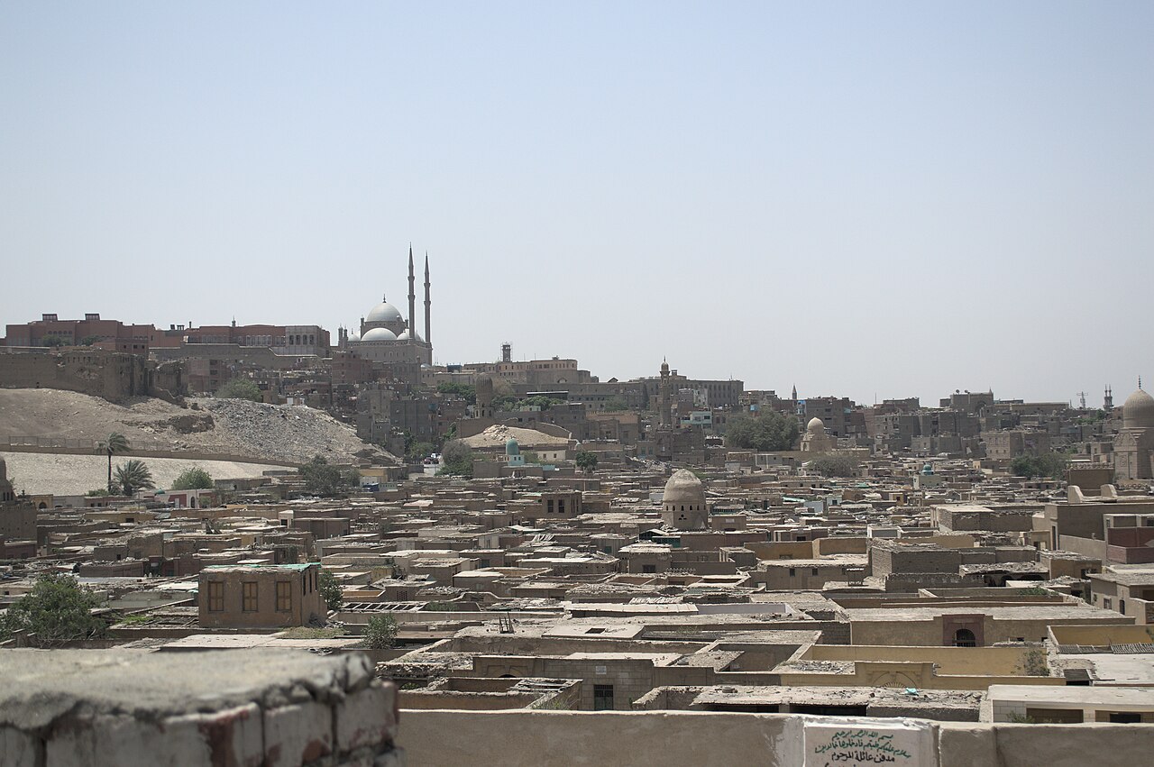
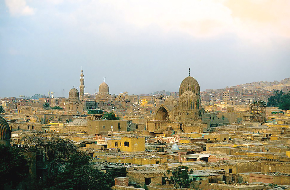
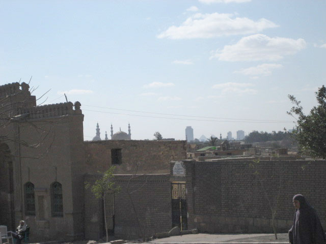
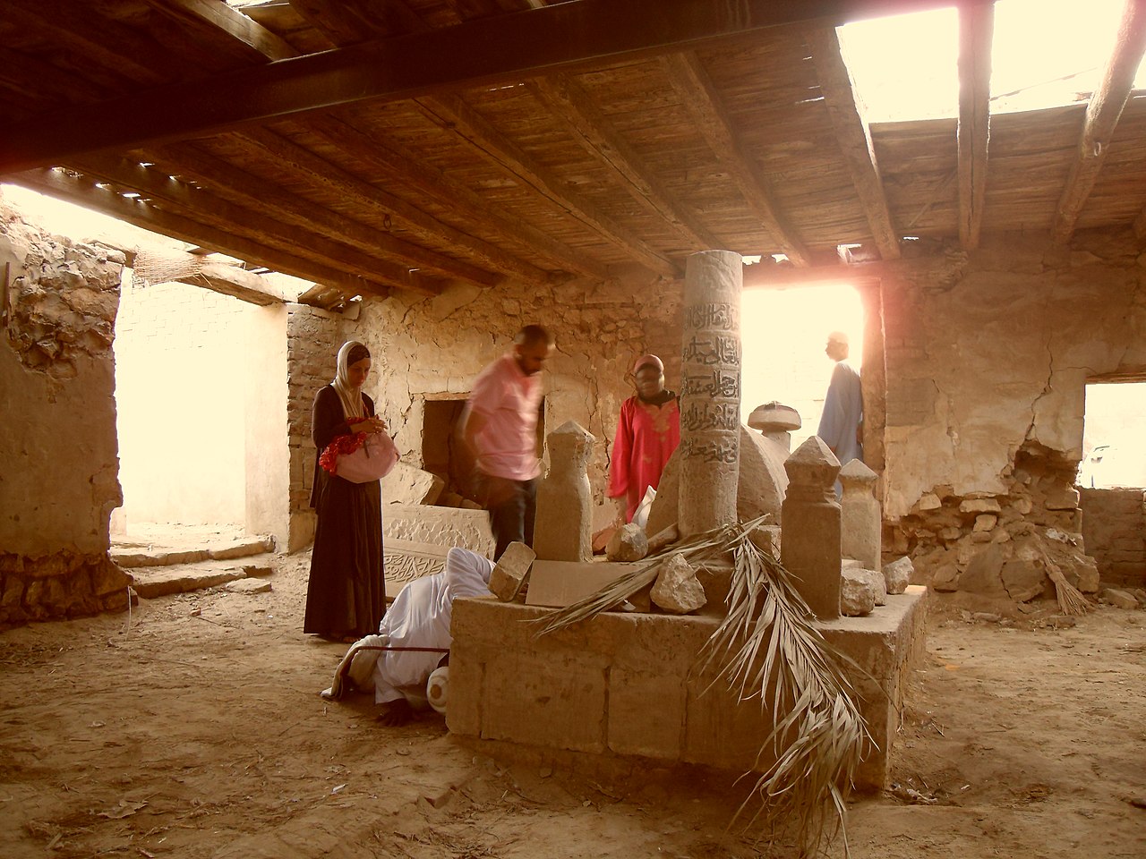
القرافة

( City of the Dead (Cairo) )

The City of the Dead, or Cairo Necropolis, also referred to as the Qarafa (Arabic: القرافة, romanized: al-Qarafa; locally pronounced as al-'arafa), is a series of vast Islamic-era necropolises and cemeteries in Cairo, Egypt. They extend to the north and to the south of the Cairo Citadel, below the Mokattam Hills and outside the historic city walls, covering an area roughly 4 miles (6.4 km) long. They are included in the UNESCO World Heritage Site of "Historic Cairo".

The necropolis is separated roughly into two regions: the Northern Cemetery to the north of the Citadel (also called the Eastern Cemetery or Qarafat ash-sharq in Arabic because it is east of the old city walls), and the older Southern Cemetery to the south of the Citadel. There is also another smaller cemetery north of Bab al-Nasr.

Th...Read more

The City of the Dead, or Cairo Necropolis, also referred to as the Qarafa (Arabic: القرافة, romanized: al-Qarafa; locally pronounced as al-'arafa), is a series of vast Islamic-era necropolises and cemeteries in Cairo, Egypt. They extend to the north and to the south of the Cairo Citadel, below the Mokattam Hills and outside the historic city walls, covering an area roughly 4 miles (6.4 km) long. They are included in the UNESCO World Heritage Site of "Historic Cairo".

The necropolis is separated roughly into two regions: the Northern Cemetery to the north of the Citadel (also called the Eastern Cemetery or Qarafat ash-sharq in Arabic because it is east of the old city walls), and the older Southern Cemetery to the south of the Citadel. There is also another smaller cemetery north of Bab al-Nasr.

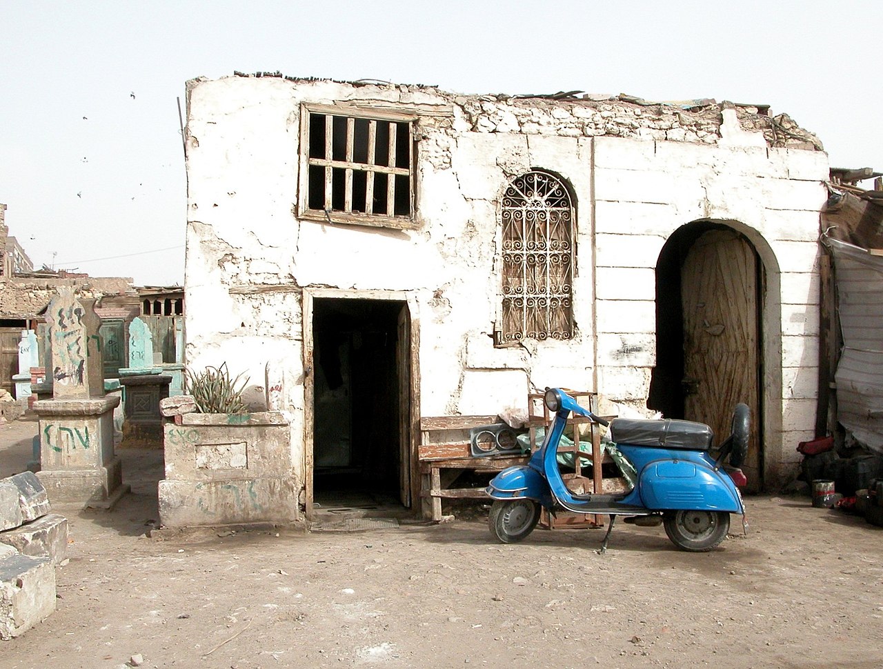
The necropolis that makes up "the City of the Dead" has been developed over many centuries and contains both the graves of Cairo's common population as well as the elaborate mausoleums of many of its historical rulers and elites. It started with the early city of Fustat (founded in 642 CE) and arguably reached its apogee, in terms of prestige and monumentality, during the Mamluk era (13th–15th centuries). Throughout their history, the necropolises were home to various types of living inhabitants as well. These included the workers whose professions were tied to the cemeteries (e.g. gravediggers, tomb custodians), the Sufis and religious scholars studying in the religious complexes built by sultans and other wealthy patrons, and the regular inhabitants of small urban settlements and villages in the area. This population grew and shrank according to circumstances in different eras. However, starting in the late 19th century and increasing in the 20th century, the pressure of Cairo's intensive urbanization and its ensuing housing shortage led to a large increase in the number of people living in the necropolis zones. Some people resorted to squatting within the mausoleums and tomb enclosures and turning them into improvised housing; however, these "tomb-dwellers" remained a small fraction of the overall population in the area. This phenomenon led to much media commentary and popular imagination about the condition of those living in the necropolises, linking them symbolically to Cairo's much-discussed overpopulation problems and sometimes leading to exaggerated estimates of the number of people squatting in the mausoleums.

Since 2020, the Egyptian government has demolished some historic tombs in the cemeteries for the purpose of building new highways and infrastructure through the area, eliciting protests and objections from locals and conservationists.

Early history (7th–10th centuries)  Excavated remains of the former city of Fustat near Old Cairo

The beginnings of Cairo's necropolis date back to the foundation and subsequent growth of the city of Fustat, founded in 642 CE by 'Amr ibn al-'As, the Arab Muslim commander who led the conquest of Egypt. The early Muslim city was divided into multiple khittat or plots of land that were allocated to different tribes, and each tribe in turn built their own cemetery and funerary district – often including a mosque – in the desert area to the east of the city.[1][2][3]: 26  The area where the Mausoleum of Imam al-Shafi'i currently stands was once the cemetery of the Quraysh tribe, the tribe of the Islamic prophet Muhammad and one of the most prestigious, and this area likely lay at the center of the cemeteries which subsequently spread north and south around it.[2][3]: 26  In the mid-8th century, just before the rise of the Abbasid Caliphate, the city's necropolis is said to have covered about 300 hectares, though its exact boundaries are unclear, other than the fact that it was outside the eastern city walls.[2]

Under Abbasid rule (starting in 750 CE), the center of government shifted to a new city founded just northeast of Fustat, called al-'Askar, and then again to another city, al-Qata'i, built by the semi-independent governor Ahmad Ibn Tulun in the 9th century. The development of the necropolis thus moved northeast, mirroring these new centers of power. For example, Ibn Tulun himself was likely buried in a newly developed cemetery south of al-Qata'i (south of the still preserved Ibn Tulun Mosque), though his tomb can no longer be found today.[4] Importantly, that area also became the site of many important tombs belonging to a number of the Prophet's descendants who emigrated to Egypt in this period, some of which, like those of Sayyida Ruqayya, Sayyida Nafisa and Sayyida Aisha, are still present today.[2][4] Further south, Imam al-Shafi'i, a Sunni religious scholar of major importance and founder of the Shafi'i madhhab, was buried in the middle of the cemetery in the early 9th century on the site of the early Quraysh cemetery. His tomb became one of the most important sites in the cemeteries even up to the present day, attracting many pilgrims and spurring development in the area at different periods.[2][5]

By the end of Abbasid rule in Egypt in the 10th century, the necropolis is reported to have covered an enormous area stretching several kilometers from the southern edge of al-Qata'i (close to the Mosque of Ibn Tulun and the later Citadel of Salah ad-Din) to the former lake of Birkat al-Habash (just south of the modern Ring Road today in the Basatin district).[2] Some historians believe that the necropolis zone was divided into two cemeteries: the Qarafat al-Sughra, or "Smaller Qarafa", located further north, and the Qarafat al-Kubra, or "Greater Qarafa", spreading over a large area further south.[1][2]: 123, 297–298  In any case, however, these terms would be used in various ways later on.

In this early period, monumental mausoleums were quite rare, graves were unadorned, and only the most important tombs might have had some distinguishing structure at all, as early Islam discouraged ostentatious tombs. The tradition of building domed mausoleums only evolved from the Fatimid period onward.[2]

Fatimid period (969–1171 CE)  Domed mausoleum (Mashhad) of Sayyida Ruqayya, dating to Fatimid times

The Fatimid dynasty revived or reintroduced ancient Egyptian traditions of building monumental mausoleums and of visiting ancestors' graves, which subsequently changed the character of the cemeteries. One impetus for this was the presence of the tombs of a number of descendants of Muhammad and of 'Ali buried here earlier. These were especially important to the Shi'i version of Islam of which the Fatimids were adherents. The Fatimids even built three shrines which were intended to house the remains of Muhammad and of the first two Shi'a caliphs/imams, but the remains were never moved here.[2] A number of other Fatimid-era mausoleums survive today in the area between the Mosques of Ibn Tulun and of Sayyida Nafisa, such as the Mausoleum of Sayyida Ruqayya.[5] During this period, the name al-Qarafat al-Kubra ("Greater Qarafa") appears to have designated the vast cemeteries associated with Fustat, which may not have merged yet with the Abbasid-era cemeteries of al-'Askar and al-Qata'i.[2][6]

The Fatimids built a number of palaces and residences within the Greater Qarafa cemetery and along the roads between Fustat and their new royal city of al-Qahira (from which the name "Cairo" originates) to the northeast.[2] These did not supplant the Great Palaces (located on the site of Bayn al-Qasrayn today), but served as leisurely retreats from the city and as places to stay while visiting the tombs of Muhammad's descendants.[2][6] Along with their palaces, the Fatimids also built mosques, madrasas, and ribats for religious instruction and activities, all of which required the creation of infrastructure for water and other necessities.[2] Among other measures, the Aqueduct of Ibn Tulun, built to provide water to al-Qata'i and passing through this area, was repaired.[2] The most important of the constructions in the Qarafa appears to have been a monumental palace complex called "al-Andalus", built in 977 by Durzan (or Taghrid), the mother of Caliph al-'Aziz.[6][7] Caliph al-Amir (reigned 1100–1130) also reportedly resided in the palace.[2][6] Durzan also built a large mosque, possibly comparable in size and layout to the Mosque of Al-Azhar, described by contemporary chroniclers and known simply as the Qarafa Mosque.[6][7] The palace was later destroyed by Salah ad-Din and the mosque is no longer extant today.[6]

These developments and practices during the Fatimid era led to the emergence, or resurgence, of the popular traditions of visiting the graves of family members and ancestors for holidays and vacations. It also set a precedent for people living in the cemeteries, as the new establishments inside the Qarafa required workers to operate, and the religious foundations attracted scholars and Sufis.[2]

The Fatimid Caliphs themselves and their family members were buried in their own mausoleum (called Turbat az-Za'faran)[2][5] on the site of what is now Khan al-Khalili, inside the city and adjacent to the Fatimid Great Palaces. However, many Fatimid officials and elites chose to be buried in the Qarafa. The presence of Taghrid's palace and mosque may have encouraged them to be buried here alongside the rest of Fustat's population.[6] Elsewhere, the Bab al-Nasr Cemetery, located just across from the Bab al-Nasr city gate, was also likely established in this period, probably starting with the powerful Fatimid vizier Badr al-Jamali (who built the gate and the city walls) choosing to be buried here when he died in 1094.[2]

Towards the end of the Fatimid period, the necropolis may have declined as the political situation worsened. The burning of Fustat in 1168 led to the decline of that city and its importance, and the ruined sections of the city may have become burial grounds integrated into the Greater Qarafa.[2]

Ayyubid period (1171–1250 CE)  The tomb of Imam al-Shafi'i today. The mausoleum dates from the Ayyubid period but was restored many times since.

The Qarafa received new attention under the Ayyubid dynasty (established by Salah ad-Din after the Fatimid Caliphate was abolished in 1171), who repaired some monuments and aqueducts and re-initiated urbanization in parts of the cemeteries (despite also destroying Fatimid monuments).[2] Most significantly, Salah ad-Din built the first Sunni madrasa in Egypt (to counter Fatimid Shi'a influence), based on the Shafi'i madhhab, right next to the tomb of Imam al-Shafi'i, while in 1211 Sultan al-Malik al-Kamil built the mausoleum and enormous dome over al-Shafi'i's tomb which remains one of the most impressive in Cairo to this day.[2][5]

The development and construction around Imam al-Shafi'i's mausoleum led to this area becoming a miniature district of its own, known as al-Qarafat al-Sughra (the "Smaller Qarafa") within the larger necropolis still known as al-Qarafat al-Kubra (the "Greater Qarafa"), which was perhaps relatively dilapidated by then. The two would later merge again as development spread to other areas.[2]

Mamluk period (1250–1517 CE)  The Southern Cemetery, near the Citadel. Various Mamluk mausoleum complexes are visible, as is the Citadel Aqueduct in the background.(Photograph from 1890)

The Mamluk sultans (1250 to 1517) were prolific builders, but most of the sultans and Mamluk elites preferred to be buried in monumental mausoleums attached to mosques and madrasas built in the city rather than in the Qarafa. In 1290, they established a new cemetery just south of the Citadel, east of the existing cemetery around the tomb of Sayyida Nafisa, on land formerly used for military training and exercises.[2] Only a relatively modest number of Mamluk funerary monuments were built here, although they were of high architectural quality and some remain today.[5] The most significant foundation here appears to have been the Zawiya of Shaykh Zayn al-Din Yusuf in 1299, which attracted pilgrims and formed the core of a new habitable district which later became the neighbourhood of al-Qadiriya.[2]

 The Mausoleum and Khanqah of Khawand Tughay (or Umm Anuk), the wife of al-Nasir Muhammad, built before 1348 in the Northern Cemetery

Under the long reign of Sultan al-Nasir Muhammad (1293–1341), Cairo's prosperity led to increased use of the Qarafa necropolis and to its revitalization, with the "Smaller Qarafa" of Ayyubid times (around the Mausoleum of Imam al-Shafi'i) now re-merging with the "Greater Qarafa".[2] This period marked the height of Cairo's wealth and power, and in turn probably marked the high point of the Qarafa in terms of prestige and splendor.[2]

In the later 14th century Cairo's population declined significantly due to the arrival of the plague. Despite the disasters, Mamluk elites continued to build extensively across Cairo. The focus of development, however, shifted from the old Qarafa, which was by then fully saturated, to new areas of development north of the Citadel, which later became what is now known as the Northern Cemetery. This desert area located between the Citadel, the city walls, and the Moqattam hills was crossed by the important pilgrimage road which led to Mecca. The road grew in importance during the Mamluk period as the Mamluks' military dominance in the region ensured the safety of the pilgrimage route.[2] The road was dotted by buildings such as caravanserais, restaurants and stables which serviced travelers.[2] Starting in 1265, Sultan Baybars turned the area into a large hippodrome for equestrian games, training, and military parades, and it became known as Maydan al-Qabaq.[2][5] In 1320, Sultan al-Nasir Muhammad put an end to the games and the military functions of the area were abandoned, but it came to be inhabited by Sufi orders searching for space outside the crowded city.[2] In turn, the Mamluks began to build their mausoleums here, also looking for more space. The Bahri Mamluks built some funerary structures here, most notably the mausoleum of al-Nasir Muhammad's favourite wife, Princess Tughay (also known as Umm Anuk), who was buried here in 1348, making it one of the earliest surviving structures in the Northern Cemetery today. Her mausoleum was accompanied by a khanqah for Sufis, which became a recurring architectural format for future funerary complexes.[5][8]

 The funerary complex of Sultan Qaytbay (in a lithograph from 1848)

It was the Burji or Circassian Mamluks, however, who contributed the most and in their time the new Northern Cemetery came to surpass the old Southern Cemetery (the old Qarafat al-Kubra) in terms of splendor.[2] As elsewhere in the city, their monuments were typically a combination of mausoleum, mosque, madrasa, khanqah and other functions. However, here they were able to build much larger complexes spread over a wider area. Many historians believe that the scale and nature of the constructions point to deliberate efforts at urbanizing the area, rather than simply using it as another necropolis.[2] The funerary complex of Sultan Qaytbay, for example, considered a masterpiece of Mamluk architecture, is often described as a "royal suburb", since it included a host of services and establishments to serve both short-term stays and long-term residents.[5][2][9] The population of the cemetery in the mid-15th century is estimated to have been around four thousand people.[5]

The Bab al-Wazir Cemetery, just north of the Citadel walls and south of the main Northern Cemetery, also dates from the Mamluk period. Starting in 1348, a number of Mamluk amirs built mausoleums and religious foundations in this area, forming another small necropolis still visible today, though it did not blend with the rest of the Northern Cemetery until later.[2][5]

By the end of the Mamluk period in the 16th century, the decline of Cairo's population and wealth also led to the decline of the necropolis zones overall, particularly the old southern Qarafa. Many of the waqf trusts which governed the functioning and upkeep of the religious foundations built throughout Cairo and its necropolis were embezzled so as to appropriate their revenues.[2] During the plague years in the 15th century, the authorities at one point officially banned people from living in the Qarafa, which left many structures unguarded and vulnerable to looting.[2] Nonetheless, in the early 16th century, Leo Africanus describes the old Qarafa (the Southern Cemetery), as being inhabited by around two thousand households.[3]: 190 

 
Mamluk funerary architecture in the Southern Cemetery, circa 1867
 
Mamluk funerary architecture in the Northern Cemetery, circa 1860
 
Bab al-Wazir Cemetery, photographed late 19th century
Ottoman rule and Khedival period (16th–19th centuries)  Exterior of the Hosh al-Basha, the mausoleum of the family of Muhammad Ali, begun in 1854

Under Ottoman rule (1517–1798), Egypt became a province of a vast empire with Istanbul as its capital. During the following three centuries Egypt was ruled by pashas, governors appointed by the Ottoman sultan. The province was highly important to the empire for its agricultural and financial support, and governors were often appointed from the highest circles of the Sultan's regime.[3] However, governors were typically appointed for a few years before being recalled because the sultans were afraid of them accumulating power.[3] One hundred and ten pashas held the office during this period and many ended their terms in jail or under house arrest.[2] Because of their short terms and other challenges in governing, the pashas were financially and politically weakened.[3] Only a small number of them left any monument attesting to their time in Egypt, and only six such monuments were in the Qarafa.[2] Even the mamluks (who remained as a political elite under Ottoman rule) did not build many new monuments in the cemeteries at this time, although many zawiyas and religious buildings were maintained and repaired.[2] The population of the cemeteries declined throughout the Ottoman period, but the necropolises nonetheless remained an important part of Cairo, with many foreign visitors during this period commenting on their size and monumental quality.[2]

 Map of the City of the Dead (Southern cemetery) in c.1800 from Description de l'Égypte – in French it was labelled Ville des tombeaux (Town of the Tombs)

Ottoman rule was suddenly ended by Napoleon Bonaparte's invasion of Egypt in 1798. The French, citing hygiene reasons, banned all burials inside the city, and cemeteries within the city walls were eventually destroyed and the remains of their occupants moved, leaving only the Qarafa (which was outside the city walls) as Cairo's major burial ground.[2] After the brief French occupation, Muhammad 'Ali, an Ottoman pasha sent from Istanbul to restore order in 1805, established his own ruling dynasty over Egypt. He and his successors, as Khedives, strove to modernize Egypt and enacted many reforms. This included efforts to restrict the use of the cemeteries to burials and funerals only, and discouraging living inhabitants from settling within them.[2] The regime also taxed waqfs, the legal trust agreements that governed many of the mausoleums and religious buildings, which reduced the ability of those who managed them to pay for the upkeep of the monuments.[2]

 Interior of the Qubbat Afandina, a royal mausoleum built in a "Neo-Mamluk" style in 1894

Despite this, the necropolises received renewed attention in the 19th century and onward. The family of Muhammad Ali himself were buried in a lavish mausoleum known as the Hosh el-Pasha, built around 1854 near the Mausoleum of Imam al-Shafi'i.[5] Perhaps following this example, many elites, royal officials, and members of the bourgeoisie began to once again build ornate mausoleums and funerary compounds in the Qarafa cemeteries.[2] These new establishments, like the old Mamluk ones, included various services which required the constant presence of workers and, by extension, the provision of housing for them. As a result, the cemeteries began to be repopulated in the 19th century, despite the authorities' changing attitudes to urban planning.[2]

Recent history (20th century to present day)  City of the Dead, the Northern Cemetery, in 1904 by Eduard Spelterini

By the end of the 19th century, however, the housing problems of Cairo began to be felt.[2] Modernization efforts led to the demolition of many old buildings in the historic districts of the city, displacing much of the poor and working class towards the outskirts of the city. Moreover, rural migration towards the cities began to rise significantly (and would only increase over the 20th century). In 1897 the census put the population of the districts which included the cemeteries at 30,969 (though this may have included some regular neighbourhoods too, given the difficulty in defining the boundaries of the cemeteries).[2]

 The City of the Dead in 1955

In some areas of the Qarafa, particularly the Imam al-Shafi'i district, permanent habitation for the living was less frowned upon and even received some help from the government. In 1907, the neighbourhood of Imam al-Shafi'i was connected to the rest of Cairo by a streetcar line which stretched from here to the Pyramids in Giza (though it no longer exists today).[2] Later, during Nasser's presidency in the 1960s, the government even built public housing on the edge of the Imam al-Shafi'i neighbourhood to house some of the people displaced by the construction of the Salah Salem highway, and some schools were also built.[2] (The construction of the Salah Salem highway, however, also implicated the destruction of some of the cemeteries along the edge of the Northern Cemetery.[10]) By 1947, the census had calculated the population of the districts including the cemeteries at 69,367, with population density having increased by a large factor.[2]

During the second half of the 20th century, rapid urbanization and the modernization of industries in and around Cairo lead to a massive migration that the city was ill-equipped to handle.[11] The intensified urbanization of Cairo itself, and the exclusion of the poorest from government initiatives, resulted in a more urgent need for informal or improvised housing.[2] Just as elsewhere in Cairo, this involved the construction of unofficial housing without government approval in areas where people could find space to build – or where they were able to demolish or incorporate older structures.[12] Moreover, the cemeteries were already filled with structures built to house family tombs – some of them quite sumptuous – which were well-suited to provide improvised housing for the homeless and displaced. In 1966 the government banned anyone from staying in the cemeteries after sundown, but were unable to enforce this.[2] The destruction of the 1992 Cairo earthquake was another instance that forced many people to move into family tombs, thus adding to the number of people already living in the City of the Dead.[13]

The phenomenon of "tomb-dwellers" (people squatting in tombs because of displacement or lack of housing in the city) probably peaked in the 1980s, when they are estimated to have been around 6,000 in number.[12] These squatters were still a very small fraction of the total population of the cemetery zones: around 3% of nearly 180,000 people at that time.[2][12] The tombs themselves were often a better alternative to squatting or low-quality housing in the inner city, as they provided already-built structures with relatively ample room, although with little access to amenities.[2]

In the 21st century, living conditions have slowly improved with greater access to running water and electricity, while the denser neighborhoods are serviced by facilities like a medical center, schools, and a post office.[14][2]

^ a b Kubiak, Wladyslaw (1987). Al-Fustat, Its Foundation and Early Development. Cairo: The American University in Cairo Press. ^ a b c d e f g h i j k l m n o p q r s t u v w x y z aa ab ac ad ae af ag ah ai aj ak al am an ao ap aq ar as at au av aw ax ay az ba bb bc Cite error: The named reference :0 was invoked but never defined (see the help page). ^ a b c d e f Raymond, André (1993). Le Caire. Paris: Fayard. ISBN 2213029830. ^ a b Swelim, Tarek (2015). Ibn Tulun: His Lost City and Great Mosque. Cairo: The American University in Cairo Press. ^ a b c d e f g h i j k Cite error: The named reference :4 was invoked but never defined (see the help page). ^ a b c d e f g Behrens-Abouseif, Doris (2018). "The Fatimid Dream of a New Capital: Dynastic Patronage and Its Imprint on the Architectural Setting". In Melikian-Chirvani, Assadullah Souren (ed.). The World of the Fatimids. Toronto; Munich: Aga Khan Museum; The Institute of Ismaili Studies; Hirmer. pp. 48–51. ^ a b Brett, Michael (2017). The Fatimid Empire. Edinburgh University Press. pp. 97–99. ^ "Darih Umm Anuk". Archnet. Retrieved 2020-07-24. ^ Behrens-Abouseif, Doris (2007). Cairo of the Mamluks: A History of the Architecture and its Culture. Cairo: The American University in Cairo Press. ^ "Egypt denies destroying ancient Islamic cemeteries to build bridge". Arab News. 2020-07-21. Retrieved 2020-07-21. ^ "Meet The Egyptian Families Who Live Among The Tombs In Cairo's Massive Cemetery". Business Insider. Retrieved 2015-04-22. ^ a b c Cite error: The named reference :1 was invoked but never defined (see the help page). ^ Tozzi Di Marco A. Il Giardino di Allah. Storia della necropoli musulmana del Cairo. Ananke edizioni 2008 ^ Lee, Jessica; Sattin, Anthony (2018). Lonely Planet Egypt (13 ed.). Lonely Planet. pp. 84–85.
Photographies by:
Robert Prazeres - CC BY-SA 4.0
Zones
Statistics: Position
5595
Statistics: Rank
16168

Add new comment

Esta pregunta es para comprobar si usted es un visitante humano y prevenir envíos de spam automatizado.

Security
213674598Click/tap this sequence: 8961

Google street view

Where can you sleep near City of the Dead (Cairo) ?

Booking.com
487.389 visits in total, 9.187 Points of interest, 404 Destinations, 15 visits today.