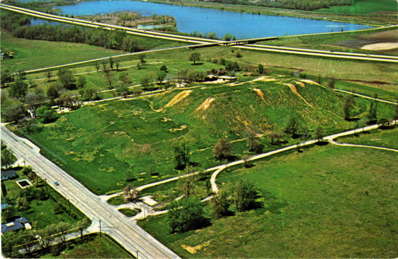
The Cahokia Mounds State Historic Site (11 MS 2) is the site of a pre-Columbian Native American city (which existed c. 1050–1350 CE) directly across the Mississippi River from present-day St. Louis, Missouri. This historic park lies in south-western Illinois between East St. Louis and Collinsville. The park covers 2,200 acres (890 ha), or about 3.5 square miles (9 km2), and contains about 80 manmade mounds, but the ancient city was much larger. At its apex around 1100 CE, the city covered about 6 square miles (16 km2), included about 120 earthworks in a wide range of sizes, shapes, and functions, and had a population of between 15,000 and 20,000 people.
Cahokia was the largest and most influential urban settlement of the Mississippian culture, which developed advanced societies across much of what is now the Central and the Southeastern United States, beginning more than 1,000 ...Read more
The Cahokia Mounds State Historic Site (11 MS 2) is the site of a pre-Columbian Native American city (which existed c. 1050–1350 CE) directly across the Mississippi River from present-day St. Louis, Missouri. This historic park lies in south-western Illinois between East St. Louis and Collinsville. The park covers 2,200 acres (890 ha), or about 3.5 square miles (9 km2), and contains about 80 manmade mounds, but the ancient city was much larger. At its apex around 1100 CE, the city covered about 6 square miles (16 km2), included about 120 earthworks in a wide range of sizes, shapes, and functions, and had a population of between 15,000 and 20,000 people.
Cahokia was the largest and most influential urban settlement of the Mississippian culture, which developed advanced societies across much of what is now the Central and the Southeastern United States, beginning more than 1,000 years before European contact. Today, the Cahokia Mounds are considered to be the largest and most complex archaeological site north of the great pre-Columbian cities in Mexico.
Cahokia Mounds is a National Historic Landmark and a designated site for state protection. It is also one of the 25 UNESCO World Heritage Sites within the United States. The largest prehistoric earthen construction in the Americas north of Mexico, the site is open to the public and administered by the Illinois Historic Preservation Division and supported by the Cahokia Mounds Museum Society. In celebration of the 2018 Illinois state bicentennial, the Cahokia Mounds were selected as one of the Illinois 200 Great Places by the American Institute of Architects Illinois component (AIA Illinois). It was recognized by USA Today Travel magazine, as one of the selections for 'Illinois 25 Must See Places'.
Although some evidence exists of occupation during the Late Archaic period (around 1200 BCE) in and around the site,[1] Cahokia as it is now defined was settled around 600 CE during the Late Woodland period. Mound building at this location began with the emergent Mississippian cultural period, around the 9th century CE.[2] The inhabitants left no written records beyond symbols on pottery, shell, copper, wood, and stone, but the elaborately planned community, woodhenge, mounds, and burials reveal a complex and sophisticated society.[3]
The city's complex construction of earthen mounds required digging, excavation and transportation by hand using woven baskets. Construction made use of 55 million cubic feet (1.6 million cubic meters) of earth, and much of the work was accomplished over decades. Its highly planned large, smoothed-flat, ceremonial plazas, sited around the mounds, with homes for thousands connected by laid out pathways and courtyards, suggest the location served as a central religious pilgrimage city.[4]
The city's original name is unknown. The mounds were later named after the Cahokia tribe, a historic Illiniwek people living in the area when the first French explorers arrived in the 17th century.[5] As this was centuries after Cahokia was abandoned by its original inhabitants, the Cahokia tribe was not necessarily descended from the earlier Mississippian-era people. Most likely, multiple indigenous ethnic groups settled in the Cahokia Mounds area during the time of the city's apex.[6][7]
Historian Daniel Richter notes that the apex of the city occurred during the Medieval Warming Period. This period appears to have fostered an agricultural revolution in upper North America, as the three-fold crops of maize, beans (legumes), and gourds (squash) were developed and adapted or bred to the temperate climates of the north from their origins in Mesoamerica. Richter also notes that Cahokia's advanced development coincided with the development in the Southwest of the Chaco Canyon society, which also produced large-scale works in an apparent socially stratified society. The decline of the city coincides with the Little Ice Age, although by then, the three-fold agriculture remained well-established throughout temperate North America.[8]
Rise and peak (11th and 12th centuries) Artist's recreation of central Cahokia. Cahokia's east–west baseline transects the Woodhenge, Monk's Mound, and several other large mounds.Cahokia became the most important center for the Mississippian culture. This culture was expressed in settlements that ranged along major waterways across what is now the Midwest, Eastern, and Southeastern United States. Cahokia was located in a strategic position near the confluence of the Mississippi, Missouri, and Illinois rivers. It maintained trade links with communities as far away as the Great Lakes to the north and the Gulf Coast to the south, trading in such exotic items as copper, Mill Creek chert,[9] and whelk shells.
Mill Creek chert, most notably, was used in the production of hoes, a high demand tool for farmers around Cahokia and other Mississippian centers. Cahokia's control of the manufacture and distribution of these hand tools was an important economic activity that allowed the city to thrive.[10] Mississippian culture pottery and stone tools in the Cahokian style were found at the Silvernale site[11] near Red Wing, Minnesota, and materials and trade goods from Pennsylvania, the Gulf Coast, and Lake Superior have been excavated at Cahokia.[12]
At the high point of its development, Cahokia was the largest urban center north of the great Mesoamerican cities in Mexico and Central America. Home to about 1,000 people before circa 1050, its population grew rapidly after that date. According to a 2007 study in Quaternary Science Reviews, "Between AD 1050 and 1100, Cahokia's population increased from between 1,400 and 2,800 people to between 10,200 and 15,300 people",[13] an estimate that applies only to a 1.8-square-kilometre (0.69 sq mi) high-density central occupation area.[14] Archaeologists estimate the city's population at between 6,000 and 40,000 at its peak,[15] with more people living in outlying farming villages that supplied the main urban center.
As a result of archeological excavations in the early 21st century, new residential areas were found to the west of Cahokia; this discovery increased estimates of historic area population.[15] If the highest population estimates are correct, Cahokia was larger than any subsequent city in the United States until the 1780s, when Philadelphia's population grew beyond 40,000.[16] Its population may have been larger than contemporaneous London[17] and Paris.[18]
One of the major problems that large centers like Cahokia faced was keeping a steady supply of food. A related problem was waste disposal for the dense population, and Cahokia is believed to have become unhealthy from polluted waterways. Because it was such an unhealthy place to live, Snow believes that the town had to rely on social and political attractions to bring in a steady supply of new immigrants; otherwise, the town's death rate would have caused it to be abandoned earlier.[10]
Decline (13th and 14th centuries) Mississippian period showing the multiple layers of mound construction, mound structures such as temples or mortuaries, ramps with log stairs, and prior structures under later layers, multiple terraces, and intrusive burialsThe population of Cahokia began to decline during the 13th century, and the site was abandoned by around 1350.[19][20] Scholars have proposed environmental factors, such as environmental degradation through overhunting, deforestation[21] and pollution,[22] and climatic changes, such as increased flooding[23] and droughts,[24][25] as explanations for abandonment of the site. However, more recent research suggests that there is no evidence of human-caused erosion or flooding at Cahokia.[26][27][19]
Political and economic problems may also have contributed to the community's decline.[28] It is likely that social and environmental factors combined to produce the conditions that led people to leave Cahokia.[29][25]
Another possible cause is invasion by outside peoples, though the only evidence of warfare found is defensive wooden stockade and watchtowers that enclosed Cahokia's main ceremonial precinct. There is no other evidence for warfare, so the palisade may have been more for ritual or formal separation than for military purposes. Diseases transmitted among the large, dense urban population are another possible cause of decline. Many theories since the late 20th century propose conquest-induced political collapse as the primary reason for Cahokia's abandonment.[30]
Together with these factors, researchers found evidence in 2015 of major floods at Cahokia, so severe as to flood dwelling places. Analysis of sediment from beneath Horseshoe Lake has revealed that two major floods occurred in the period of settlement at Cahokia, in roughly 1100–1260 and 1340–1460.[31][32] While flooding may have occurred early in the rise of the city, it seems not to have deterred the city builders; to the contrary, it appears they took steps such as creating channels, dykes, and levees that protected at least the central city throughout its inhabited history.[26]
Archeologists discovered evidence in 2020 that there was a population rebound following Cahokia's population minimum in 1400, with the population reaching a population maximum in 1650 and then declining again in 1700.[33]
Add new comment