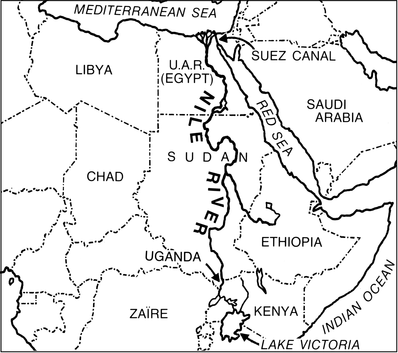
نهر النيل

( Nile )
Fanny Schertzer - CC BY-SA 4.0 ER's Eyes - Our planet is beautiful. tnchanse ER's Eyes - Our planet is beautiful. ER's Eyes - Our planet is beautiful. tnchanse Duchess Flux outdoorPDK CDay DaytimeStudios w > 2 Million views orientalizing moments in nature by Antje Schultner akahawkeyefan moominsean ralf.st orientalizing CDay DaytimeStudios w > 2 Million views CDay DaytimeStudios w > 2 Million views cattan2011 cattan2011 orientalizing cattan2011 ER's Eyes - Our planet is beautiful. orientalizing moominsean cattan2011 gregorywass joe.jun.liao Alan Cruickshank Photographic Scriblerus Rita Willaert Rita Willaert Schaffner ER's Eyes - Our planet is beautiful. www.holgersbilderwelt.de ER's Eyes - Our planet is beautiful. cattan2011 Rod Waddington tnchanse europeanspaceagency like, totally tnchanse moominsean ER's Eyes - Our planet is beautiful. tnchanse tnchanse CDay DaytimeStudios w > 2 Million views tnchanse akahawkeyefan moominsean ralf.st tnchanse moominsean ER's Eyes - Our planet is beautiful. ER's Eyes - Our planet is beautiful. Schaffner cattan2011 The Boy from Bare Rod Waddington PHOTOPHANATIC1 tnchanse Christopher.Michel Marwa Morgan tnchanse PHOTOPHANATIC1 ER's Eyes - Our planet is beautiful. Rod Waddington Schaffner reillyandrew cattan2011 cattan2011 cattan2011 Francisco Anzola Thad Zajdowicz bitsorf: Thank you 1,500,000 times Schaffner A.Davey moominsean Schaffner tnchanse ER's Eyes - Our planet is beautiful. Lars Plougmann tnchanse ralf.st Schaffner archer10 (Dennis) Curtis Gregory Perry davdenic ER's Eyes - Our planet is beautiful. tomswift46 ( Hi Res Images for the asking) Schaffner melibeo Thomas Hawk ER's Eyes - Our planet is beautiful. Larry Myhre tnchanse Schaffner moominsean tnchanse moominsean MarcCooper_1950 Mountain and travel CDay DaytimeStudios w > 2 Million views Andy Morffew Rod Waddington davidseibold Photomatt28 Curtis Gregory Perry ER's Eyes - Our planet is beautiful. Rod Waddington M McBey cattan2011 Lars Plougmann NASA Goddard Photo and Video PHOTOPHANATIC1 Lars Plougmann szpako Martin_Heigan PHOTOPHANATIC1 Gwenaël Piaser Cloudtail the Snow Leopard Schaffner Rod Waddington avrene ER's Eyes - Our planet is beautiful. bitsorf: Thank you 1,500,000 times Schaffner Schaffner ER's Eyes - Our planet is beautiful. Nicholas Eckhart ER's Eyes - Our planet is beautiful. NIAID Miquel99 like, totally NASA's Marshall Space Flight Center moominsean MarcCooper_1950 Anita363 srevilo Doug Greenberg Zoriah Art Gallery ErgsArt moominsean leighklotz Rod Waddington MarcCooper_1950 D-Stanley Schaffner D-Stanley cattan2011 Puno3000 valerian.guillot Cloudtail the Snow Leopard cattan2011 NIAID ER's Eyes - Our planet is beautiful. raymondclarkeimages Aitor Uranga kairoinfo4u OSU Special Collections & Archives : Commons Panegyrics of Granovetter ER's Eyes - Our planet is beautiful. D-Stanley Marwa Morgan MarcCooper_1950 sniggie ER's Eyes - Our planet is beautiful. Rod Waddington Rod Waddington M1key.me moominsean rjhuttondfw ER's Eyes - Our planet is beautiful. moominsean D-Stanley NIAID D-Stanley valerian.guillot NIAID ER's Eyes - Our planet is beautiful. ER's Eyes - Our planet is beautiful. Swamibu Schaffner ESA_events guppiecat Starr Environmental Alwyn Ladell dungodung garryknight Nicholas Eckhart Edu-Tourist johanlb Ben Templesmith kairoinfo4u Puno3000 netllama_ Nicholas Eckhart Steve Walser Christopher.Michel netllama_ World Bank Photo Collection Phase Locked Loop kairoinfo4u D-Stanley Larry Myhre valerian.guillot GRIDArendal valerian.guillot Phase Locked Loop PHOTOPHANATIC1 Kansas Poetry (Patrick) Aitor Uranga Lars Plougmann Ranil CDay DaytimeStudios w > 2 Million views Rod Waddington Kieran Clarke valerian.guillot rocor pyramidtextsonline Jocelyn777 Love Europe kairoinfo4u guppiecat Jack Snell - Thanks for over 26 Million Views Phase Locked Loop westpark Christopher.Michel valerian.guillot Christopher.Michel guppiecat MarcCooper_1950 Antonio Ventaja Christopher.Michel Dennis S. Hurd Downtown Warren History shaimaa85 Christopher.Michel Phase Locked Loop snowcrash98 Phase Locked Loop bigdmia Gabriel J. H. Smithsonian's National Zoo Cloudtail the Snow Leopard davidseibold wallygrom Digital Aesthetica Dissonancefalling guppiecat Meta-Man Rita Willaert Phase Locked Loop NASA HQ PHOTO motazabdelazeem صور من الوطن Ahmed Rabea zireael2005 mrcharly jkonrath Rod Waddington Arno Meintjes Wildlife Dennis S. Hurd eutrophication&hypoxia The National Archives UK Phase Locked Loop Phase Locked Loop Martin_Heigan zireael2005 Dennis S. Hurd Mike Roqué Bubba's Bag of Photos water.alternatives mttsndrs pyramidtextsonline NASA Goddard Photo and Video Moody Man jimmywayne 10b travelling (sorry: glitch, so resubmitting) Человек с Урала DafneCholet ICARDA - Science for Resilient Livelihoods in Dry Christopher.Michel NOAASatellites 10b travelling (sorry: glitch, so resubmitting) PHOTOPHANATIC1 Thomas Hawk Hossam el-Hamalawy حسام الحملاوي 10b travelling (sorry: glitch, so resubmitting) Julien MANGEZ Joe Mabel Dorli Photography Bernard DUPONT Dolly Dolly UK Terrazzo Ranoush. The Library of Congress netllama_ denisbin Christopher.Michel Palap Michell Zappa Dinesh Valke water.alternatives zolakoma m.tamawy2014 a rancid amoeba -Meesho- Eva Rinaldi Celebrity Photographer shankar s. Bernard DUPONT chericbaker Gardening Solutions Jorge Lascar Fragile Oasis chericbaker Mike Roqué Antiporda Productions LV, LLC Aroa MABdolls Mike Roqué LucaP Eva Rinaldi Celebrity Photographer davidseibold Dinesh Valke gordontour just.Luc worldwaterweek maltman23 Ninara31 Christopher.Michel archer10 (Dennis) Aitor Uranga Christopher.Michel Christopher.Michel Jordan Alexander Hartley j-No Schaffner Christopher.Michel NASA Johnson zireael2005 Michael Gwyther-Jones Michael Gwyther-Jones zolakoma zireael2005 Thomas Hawk Ninara31 tamburix Mathew Knott Dinesh Valke Futurilla zolakoma SdosRemedios Property#1 Dinesh Valke Marwa Morgan Dissonancefalling lisby1 khalid almasoud chericbaker mountain wanderer Smithsonian's National Zoo Alabama Extension shankar s. 350.org Christopher.Michel Beautiful Ethiopia Christopher.Michel Ashit Desai jimmie-quickity USAID Africa zolakoma m.tamawy2014 Miami U. Libraries - Digital Collections isawnyu w_lemay motazabdelazeem صور من الوطن PHOTOPHANATIC1 followthethings.com Aitor Uranga whl.travel m.tamawy2014 Cushing Memorial Library and Archives, Texas A&M Jorge Lascar pullip_junk jimmie-quickity Bernard DUPONT Chalky Lives Kodak Agfa Michael Gwyther-Jones zireael2005 G · RTM Michael Gwyther-Jones jimmie-quickity wwarby Pierre Lesage Terrazzo San Diego Air & Space Museum Archives neiljs shankar s. Smithsonian's National Zoo Lauren PM jonl1973 jimmie-quickity City of PAE Libraries’ local historical photos CDay DaytimeStudios w > 2 Million views Bernard DUPONT chericbaker NASA Johnson Aussie~mobs 10b travelling (sorry: glitch, so resubmitting) zireael2005 mrcharly dungodung runatyrwyn Ryan Somma Kestenbaum Dennis S. Hurd YoTuT Arian Zwegers zolakoma Moody Man SentinelHub Lucas Alexandros Lip Kee othalan zireael2005 bitsorf: Thank you 1,500,000 times mharrsch Kestenbaum Schaffner Nassef © Curtis Gregory Perry Rita Willaert marneejill bitsorf: Thank you 1,500,000 times Sally Payne orientalizing Christopher.Michel Christopher.Michel Aitor Uranga Schaffner Schaffner Christopher.Michel Panegyrics of Granovetter Christopher.Michel bitsorf: Thank you 1,500,000 times Arno Meintjes Wildlife NASA's Marshall Space Flight Center Vít Hassan tnchanse Dissonancefalling Panegyrics of Granovetter Dissonancefalling samir.beorn Christopher.Michel bluesbby Dissonancefalling Christopher.Michel ESA_events Gary Lee Todd, Ph.D. Art Gallery ErgsArt guppiecat Aitor Uranga Eva Rinaldi Celebrity Photographer NoJuan Miquel99 Phase Locked Loop Ahmed Rabea Iey Aitor Uranga rottnapples JuhaOnTheRoad martin.pennings Christopher.Michel Aitor Uranga pullip_junk rezendi jjmusgrove sjrankin Phase Locked Loop Aitor Uranga Dissonancefalling Sierragoddess Dissonancefalling Moody Man MA1216 Michell Zappa isawnyu CDay DaytimeStudios w > 2 Million views Alastair Rae mpliu zolakoma -Meesho- Aitor Uranga LaggedOnUser D'Arcy Vallance Melissa O'Donohue radiowood Dissonancefalling zolakoma Jarjan zolakoma Dale Gillard Michael Fraley MNmagic Baron Reznik Baron Reznik khalid almasoud khalid almasoud Hossam all line Hossam all line motazabdelazeem صور من الوطن motazabdelazeem صور من الوطن Sowr Hossam all line Hossam el-Hamalawy حسام الحملاوي giancornachini wosom Hossam all line Hossam all line 5min.pw Hossam all line Hossam all line giancornachini giancornachini wosom wosom giancornachini giancornachini giancornachini giancornachini giancornachini motazabdelazeem صور من الوطن wosom Hossam all line Hossam all line wosom motazabdelazeem صور من الوطن Hossam all line Hossam all line 5min.pw Hossam all line Osama ALASSIRY Hossam all line 5min.pw 5min.pw 5min.pw 5min.pw http://bluemix.me 5min.pw 5min.pw motazabdelazeem صور من الوطن 5min.pw 5min.pw 5min.pw 5min.pw 5min.pw 5min.pw motazabdelazeem صور من الوطن motazabdelazeem صور من الوطن ahmed samir asfour motazabdelazeem صور من الوطن khalid almasoud Hossam all line

The Nile is a major north-flowing river in northeastern Africa. It flows into the Mediterranean Sea. The Nile is the longest river in Africa and has historically been considered the longest river in the world, though this has been contested by research suggesting that the Amazon River is slightly longer. Of the world's major rivers, the Nile is one of the smallest, as measured by annual flow in cubic metres of water. About 6,650 km (4,130 mi) long, its drainage basin covers eleven countries: the Democratic Republic of the Congo, Tanzania, Burundi, Rwanda, Uganda, Kenya, Ethiopia, Eritrea, South Sudan, Republic of the Sudan, and Egypt. In particular, the Nile is the primary water source of Egypt, Sudan and South Sudan. Additionally, the Nile is an important economic river, supporting agriculture and fishing.

The Nile has two major tributaries – the White Nile and the Blue Nile. The White Nile is traditionally considered to be the headwater...Read more

The Nile is a major north-flowing river in northeastern Africa. It flows into the Mediterranean Sea. The Nile is the longest river in Africa and has historically been considered the longest river in the world, though this has been contested by research suggesting that the Amazon River is slightly longer. Of the world's major rivers, the Nile is one of the smallest, as measured by annual flow in cubic metres of water. About 6,650 km (4,130 mi) long, its drainage basin covers eleven countries: the Democratic Republic of the Congo, Tanzania, Burundi, Rwanda, Uganda, Kenya, Ethiopia, Eritrea, South Sudan, Republic of the Sudan, and Egypt. In particular, the Nile is the primary water source of Egypt, Sudan and South Sudan. Additionally, the Nile is an important economic river, supporting agriculture and fishing.

The Nile has two major tributaries – the White Nile and the Blue Nile. The White Nile is traditionally considered to be the headwaters stream. However, the Blue Nile is the source of most of the water of the Nile downstream, containing 80% of the water and silt. The White Nile is longer and rises in the Great Lakes region. It begins at Lake Victoria and flows through Uganda and South Sudan. The Blue Nile begins at Lake Tana in Ethiopia and flows into Sudan from the southeast. The two rivers meet at the Sudanese capital of Khartoum.
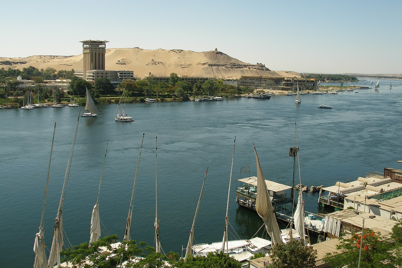
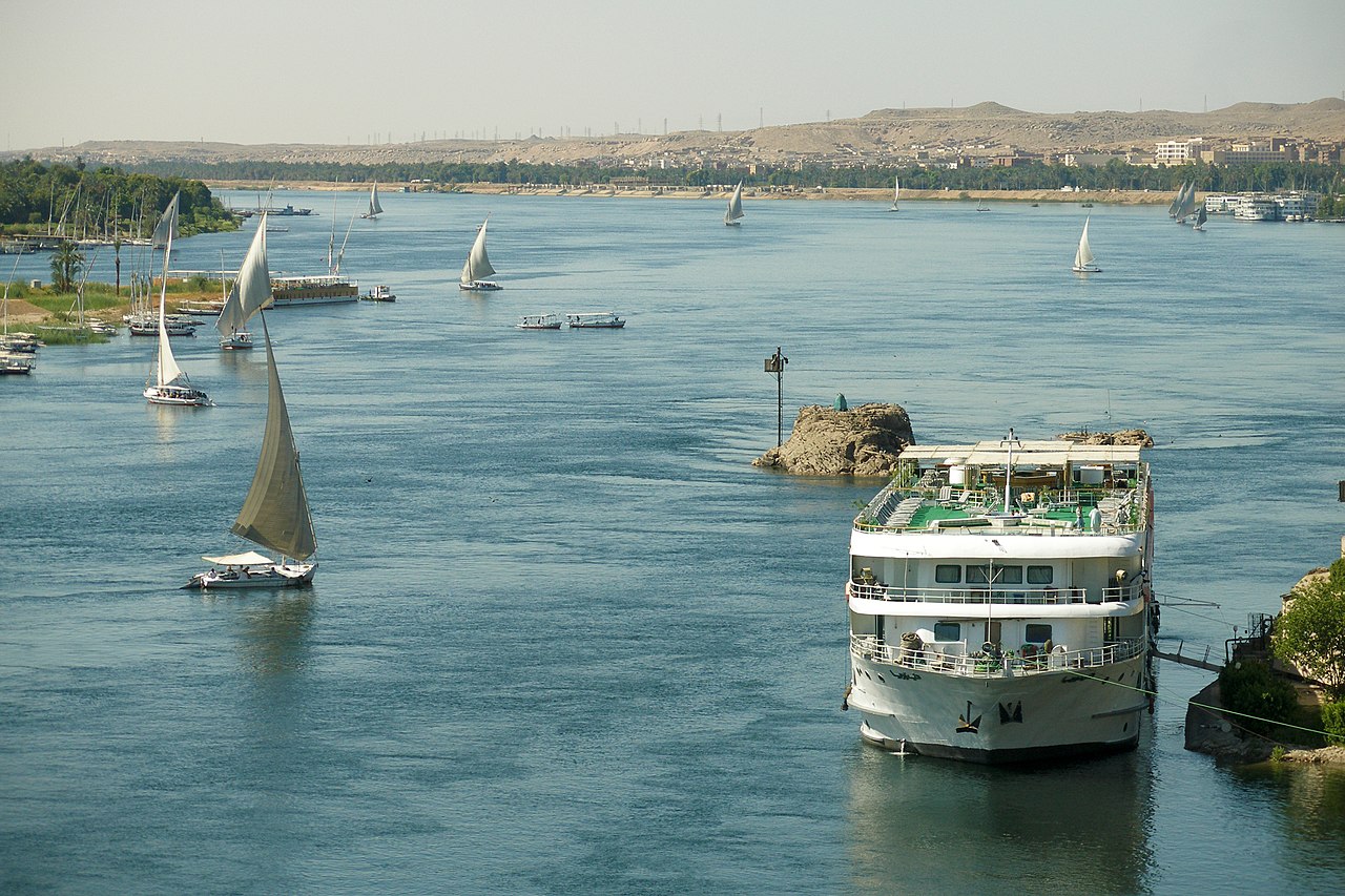
The northern section of the river flows north almost entirely through the Nubian Desert to Cairo and its large delta, and the river flows into the Mediterranean Sea at Alexandria. Egyptian civilization and Sudanese kingdoms have depended on the river and its annual flooding since ancient times. Most of the population and cities of Egypt lie along those parts of the Nile valley north of the Aswan Dam. Nearly all the cultural and historical sites of Ancient Egypt developed and are found along river banks. The Nile is, with the Rhône and Po, one of the three Mediterranean rivers with the largest water discharge.

 
Reconstruction of the Oikoumene (inhabited world), an ancient map based on Herodotus' description of the world, circa 450 BC

The Nile has been the lifeline of civilization in Egypt since the Stone Age, with most of the population and all of the cities of Egypt developing along those parts of the Nile valley lying north of Aswan. However, the Nile used to run much more westerly through what is now Wadi Hamim and Wadi al Maqar in Libya and flow into the Gulf of Sidra.[1] As the sea level rose at the end of the most recent ice age, the stream which is now the northern Nile captured the ancestral Nile near Asyut.[2] This change in climate also led to the current extents of the Sahara desert, around 3400 BCE.[3]

Khufu branch

The Giza Pyramid Complex originally overlooked a branch of the Nile that no longer exists. This branch was highest during the African Humid Period.[4][5]

Ancient Niles

The existing Nile has five earlier phases; i) the Upper Miocenian Eonile, of about 6 million years BP,[6][7] ii) the Upper Pliocenian Paleonile, commencing about 3.32 million years BP, and during the Pleistocene, the Nile phases iii) Proto-Nile, commencing about 600,000 years BP, iv) Pre-Nile,[8] transitioning at about 400,000 years BP to the[6] v) Neo-Nile.[8] Flowing north from the Ethiopian Highlands, satellite imagery was used to identify dry watercourses in the desert to the west of the Nile. A canyon, now filled by surface drift, represents the Eonile that flowed during 23–5.3 million years before present. The Eonile transported clastic sediments to the Mediterranean; several natural gas fields have been discovered within these sediments.

During the late-Miocene Messinian salinity crisis, when the Mediterranean Sea was a closed basin and evaporated to the point of being empty or nearly so, the Nile cut its course down to the new base level until it was several hundred metres below world ocean level at Aswan and 2,400 m (7,900 ft) below Cairo.[9][10] This created a very long and deep canyon which was filled with sediment after the Mediterranean was recreated.[11] At some point the sediments raised the riverbed sufficiently for the river to overflow westward into a depression to create Lake Moeris.

Lake Tanganyika drained northwards into the Nile until the Virunga Volcanoes blocked its course in Rwanda. The Nile was much longer at that time, with its furthest headwaters in northern Zambia. The currently existing Nile first flowed during the former parts of the Würm glaciation period.[7]

Integrated Nile

There are two theories about the age of the integrated Nile. One is that the integrated drainage of the Nile is of young age and that the Nile basin was formerly broken into series of separate basins, only the most northerly of which fed a river following the present course of the Nile in Egypt and Sudan. Rushdi Said postulates that Egypt supplied most of the waters of the Nile during the early part of its history.[12]

The other theory is that the drainage from Ethiopia via rivers equivalent to the Blue Nile, the Atbara and the Takazze flowed to the Mediterranean via the Egyptian Nile since well back into Tertiary times.[13]

Salama suggests that during the Paleogene and Neogene Periods (66 million to 2.588 million years ago) a series of separate closed continental basins each occupied one of the major parts of the Sudanese Rift System: Mellut rift, White Nile rift, Blue Nile rift, Atbara rift and Sag El Naam rift.[14] The Mellut Basin is nearly 12 kilometers (7.5 mi) deep at its central part. This rift is possibly still active, with reported tectonic activity in its northern and southern boundaries. The Sudd swamp which forms the central part of the basin may still be subsiding. The White Nile Rift system, although shallower than the Bahr el Arab rift, is about 9 kilometers (5.6 mi) deep. Geophysical exploration of the Blue Nile Rift System estimated the depth of the sediments to be 5–9 kilometers (3.1–5.6 mi). These basins were not interconnected until their subsidence ceased, and the rate of sediment deposition was enough to fill and connect them.

The Egyptian Nile connected to the Sudanese Nile, which captures the Ethiopian and Equatorial headwaters during the current stages of tectonic activity in the Eastern, Central and Sudanese Rift systems.[15] The connection of the different Niles occurred during cyclic wet periods. The Atbarah overflowed its closed basin during the wet periods that occurred about 100,000 to 120,000 years ago. The Blue Nile connected to the main Nile during the 70,000–80,000 years B.P. wet period. The White Nile system in Bahr El Arab and White Nile Rifts remained a closed lake until the connection of the Victoria Nile to the main system some 12,500 years ago during the African humid period.

Role in the founding of Egyptian civilization
 
An aerial view of irrigation from the Nile River supporting agriculture in Luxor, Egypt
 
A felucca traversing the Nile near Aswan

The Greek historian Herodotus wrote that "Egypt was the gift of the Nile". An unending source of sustenance, it played a crucial role in the development of Egyptian civilization. Because the river overflowed its banks annually and deposited new layers of silt, the surrounding land was very fertile. The Ancient Egyptians cultivated and traded wheat, flax, papyrus and other crops around the Nile. Wheat was a crucial crop in the famine-plagued Middle East. This trading system secured Egypt's diplomatic relationships with other countries and contributed to economic stability. Far-reaching trade has been carried on along the Nile since ancient times.[citation needed] A tune, Hymn to the Nile, was created and sung by the ancient Egyptian peoples about the flooding of the Nile River and all of the miracles it brought to Ancient Egyptian civilization.[16]

Water buffalo were introduced from Asia, and the Assyrians introduced camels in the 7th century BCE. These animals were raised for meat and were domesticated and used for ploughing—or in the camels' case, carriage. Water was vital to both people and livestock. The Nile was also a convenient and efficient means of transportation for people and goods.

The Nile was also an important part of ancient Egyptian spiritual life. Hapi was the god of the annual floods, and both he and the pharaoh were thought to control the flooding. The Nile was considered to be a causeway from life to death and the afterlife. The east was thought of as a place of birth and growth, and the west was considered the place of death, as the god Ra, the Sun, underwent birth, death, and resurrection each day as he crossed the sky. Thus, all tombs were west of the Nile, because the Egyptians believed that in order to enter the afterlife, they had to be buried on the side that symbolized death.[citation needed]

As the Nile was such an important factor in Egyptian life, the ancient calendar was even based on the three cycles of the Nile. These seasons, each consisting of four months of thirty days each, were called Akhet, Peret, and Shemu. Akhet, which means inundation, was the time of the year when the Nile flooded, leaving several layers of fertile soil behind, aiding in agricultural growth.[17] Peret was the growing season, and Shemu, the last season, was the harvest season when there were no rains.[17]

European search for the source
 
John Hanning Speke c. 1863. Speke was the Victorian explorer who first reached Lake Victoria in 1858, returning to establish it as the source of the Nile by 1862.[18]

Owing to their failure to penetrate the Sudd wetlands of South Sudan, the upper reaches of the White Nile remained largely unknown to the ancient Greeks and Romans. Various expeditions failed to determine the river's source. Agatharchides records that in the time of Ptolemy II Philadelphus, a military expedition had penetrated far enough along the course of the Blue Nile to determine that the summer floods were caused by heavy seasonal rainstorms in the Ethiopian Highlands, but no European of antiquity is known to have reached Lake Tana. The Tabula Rogeriana depicted the source as three lakes in 1154.

Europeans began to learn about the origins of the Nile in the 14th century when the Pope sent monks as emissaries to Mongolia who passed India, the Middle East and Africa, and described being told of the source of the Nile in Abyssinia (Ethiopia)[19] Later in the 15th and 16th centuries, travelers to Ethiopia visited Lake Tana and the source of the Blue Nile in the mountains south of the lake. Putatively, Paolo Trevisani (circa 1452-1483), a Venetian traveller in Ethiopia, wrote a journal of his travels to the origin of the Nile that has since been lost.[20][21] Although James Bruce claimed to be the first European to have visited the headwaters,[22] modern writers give the credit to the Jesuit Pedro Páez. Páez's account of the source of the Nile[23] is a long and vivid account of Ethiopia. It was published in full only in the early 20th century, although it was featured in works of Páez's contemporaries, including Baltazar Téllez,[24] Athanasius Kircher[25] and by Johann Michael Vansleb.[26]

Europeans had been resident in Ethiopia since the late 15th century, and one of them may have visited the headwaters even earlier without leaving a written trace. The Portuguese João Bermudes published the first description of the Tis Issat Falls in his 1565 memoirs, compared them to the Nile Falls alluded to in Cicero's De Republica.[27] Jerónimo Lobo describes the source of the Blue Nile, visiting shortly after Pedro Páez. Telles also uses his account.

The White Nile was even less understood. The ancients mistakenly believed that the Niger River represented the upper reaches of the White Nile. For example, Pliny the Elder writes that the Nile had its origins "in a mountain of lower Mauretania", flowed above ground for "many days" distance, then went underground, reappeared as a large lake in the territories of the Masaesyli, then sank again below the desert to flow underground "for a distance of 20 days' journey till it reaches the nearest Ethiopians."[28]

 
A map of the Nile c. 1911, a time when its entire primary course ran through British occupations, condominiums, colonies, and protectorates[29]

Modern exploration of the Nile basin began with the conquest of the northern and central Sudan by the Ottoman viceroy of Egypt, Muhammad Ali, and his sons from 1821 onward. As a result of this, the Blue Nile was known as far as its exit from the Ethiopian foothills and the White Nile as far as the mouth of the Sobat River. Three expeditions under a Turkish officer, Selim Bimbashi, were made between 1839 and 1842, and two got to the point about 30 kilometres (20 miles) beyond the present port of Juba, where the country rises and rapids make navigation very difficult.

Lake Victoria was first sighted by Europeans in 1858 when British explorer John Hanning Speke reached its southern shore while traveling with Richard Francis Burton to explore central Africa and locate the great lakes. Believing he had found the source of the Nile on seeing this "vast expanse of open water" for the first time, Speke named the lake after Queen Victoria. Burton, recovering from illness and resting further south on the shores of Lake Tanganyika, was outraged that Speke claimed to have proven his discovery to be the true source of the Nile when Burton regarded this as still unsettled. A quarrel ensued which sparked intense debate within the scientific community and interest by other explorers keen to either confirm or refute Speke's discovery. British explorer and missionary David Livingstone pushed too far west and entered the Congo River system instead. It was ultimately Welsh-American explorer Henry Morton Stanley who confirmed Speke's discovery, circumnavigating Lake Victoria and reporting the great outflow at Ripon Falls on the lake's northern shore.

Since 1950
 
The confluence of the Kagera and Ruvubu rivers near Rusumo Falls, part of the Nile's upper reaches
 
Dhows on the Nile
 
The Nile passes through Cairo, Egypt's capital city.

The Nile has long been used to transport goods along its length. Winter winds blow south, up river, so ships could sail up river using sails and down river using the flow of the river. While most Egyptians still live in the Nile valley, the 1970 completion of the Aswan Dam ended the summer floods and their renewal of the fertile soil, fundamentally changing farming practices. The Nile supports much of the population living along its banks, enabling Egyptians to live in otherwise inhospitable regions of the Sahara. The river's flow is disturbed at several points by the Cataracts of the Nile which form an obstacle to navigation by boats. The Sudd also forms a formidable navigation obstacle and impedes water flow, to the extent that Sudan had once attempted to build the Jonglei Canal to bypass the swamp.[30][31]

Nile cities include Khartoum, Aswan, Luxor (Thebes), and the Giza – Cairo conurbation. The first cataract, the closest to the mouth of the river, is at Aswan, north of the Aswan Dam. This part of the river is a regular tourist route, with cruise ships and traditional wooden sailing boats known as feluccas. Many cruise ships ply the route between Luxor and Aswan, stopping at Edfu and Kom Ombo along the way. Security concerns have limited cruising on the northernmost portion for many years.

A computer simulation study to plan the economic development of the Nile was directed by H.A.W. Morrice and W.N. Allan, for the Ministry of Hydro-power of Sudan, during 1955–57[32][33][34] Morrice was their hydrological adviser, and Allan his predecessor. The calculations were enabled by accurate monthly inflow data collected for 50 years. The underlying principle was the use of over-year storage, to conserve water from rainy years for use in dry years. Irrigation, navigation and other needs were considered. Each computer run postulated a set of reservoirs and operating equations for the release of water as a function of the month and the levels upstream. The behavior that would have resulted given the inflow data was modeled. Over 600 models were run. Recommendations were made to the Sudanese authorities. The calculations were run on an IBM 650 computer. Simulation studies to design water resources are discussed further in the article on hydrology transport models, which have been used since the 1980s to analyze water quality.

Despite the development of many reservoirs, drought during the 1980s led to widespread starvation in Ethiopia and Sudan, but Egypt was nourished by water impounded in Lake Nasser. Drought has proven to be a major cause of fatality in the Nile river basin. According to a report by the Strategic Foresight Group around 170 million people have been affected by droughts in the last century with half a million lives lost.[35] From the 70 incidents of drought which took place between 1900 and 2012, 55 incidents took place in Ethiopia, Sudan, South Sudan, Kenya and Tanzania.[35]

^ Carmignani, Luigi; Salvini, Riccardo; Bonciani, Filippo (2009). "Did the Nile River flow to the Gulf of Sirt during the late Miocene?". Bollettino della Societa Geologica Italiana (Italian Journal of Geoscience). 128 (2): 403–408. doi:10.3301/IJG.2009.128.2.403 (inactive 31 December 2022).{{cite journal}}: CS1 maint: DOI inactive as of December 2022 (link) ^ Salvini, Riccardo; Carmignani, Luigi; Francionib, Mirko; Casazzaa, Paolo (2015). "Elevation modelling and palaeo-environmental interpretation in the Siwa area (Egypt): Application of SAR interferometry and radargrammetry to COSMO-SkyMed imagery". Catena. 129: 46–62. Bibcode:2015Caten.129...46S. doi:10.1016/j.catena.2015.02.017. hdl:10871/20327. ^ Although the ancestral Sahara Desert initially developed at least 7 million years ago, it grew during interglacial periods and shrank during glacial ones. The growth of the current Sahara began about 6,000 years ago. Schuster, Mathieu; et al. (2006). "The age of the Sahara desert". Science. 311 (5762): 821. doi:10.1126/science.1120161. PMID 16469920. S2CID 206508108. ^ Sheisha, Hader (2022). "Nile waterscapes facilitated the construction of the Giza pyramids during the 3rd millennium BCE". PNAS. 119 (37): e2202530119. Bibcode:2022PNAS..11902530S. doi:10.1073/pnas.2202530119. PMC 9477388. PMID 36037388. ^ Solis-Moreira, Jocelyn (31 August 2022). "A dried-up arm of the Nile provides another clue to how Egyptians built the pyramids". Popular Science. Retrieved 2 September 2022. ^ a b Said, Rushdi (22 October 2013). The River Nile Geology, Hydrology and Utilization (Ebook) (22 October 2013 ed.). Elsevier Science (published 1993). p. 1. ISBN 9781483287683. Retrieved 23 May 2021. ^ a b Cite error: The named reference Said 3 x 3 was invoked but never defined (see the help page). ^ a b Said, R (1976). "The Geological Evolution of the River Nile in Egypt". In Rzóska, J. (ed.). The Nile, Biology of an Ancient River. Monographiae Biologicae. Vol. 29. Dordrecht: Springer. p. 2. doi:10.1007/978-94-010-1563-9_1. ISBN 978-94-010-1563-9. Archived from the original on 23 May 2021. Retrieved 23 May 2021 – via Microsoft Academic. ^ Warren, John (2006). Evaporites: Sediments, Resources and Hydrocarbons. Berlin: Springer. p. 352. ISBN 3-540-26011-0. ^ El Mahmoudi, A.; Gabr, A. (2008). "Geophysical surveys to investigate the relation between the Quaternary Nile channels and the Messinian Nile canyon at East Nile Delta, Egypt". Arabian Journal of Geosciences. 2 (1): 53–67. doi:10.1007/s12517-008-0018-9. ISSN 1866-7511. S2CID 128432827. ^ Embabi, N.S. (2018). "Remarkable Events in the Life of the River Nile". Landscapes and Landforms of Egypt. World Geomorphological Landscapes. pp. 39–45. doi:10.1007/978-3-319-65661-8_4. ISBN 978-3-319-65659-5. ISSN 1866-7538. ^ Said, R. (1981). The geological evolution of the River Nile. Springer Verlag. ^ Williams, M.A.J.; Williams, F. (1980). Evolution of Nile Basin. In M.A.J. Williams and H. Faure (eds). The Sahara and the Nile. Balkema, Rotterdam, pp. 207–224. ^ Salama, R.B. (1987). "The evolution of the River Nile, The buried saline rift lakes in Sudan". Journal of African Earth Sciences. 6 (6): 899–913. doi:10.1016/0899-5362(87)90049-2. ^ Salama, R.B. (1997). Rift Basins of Sudan. African Basins, Sedimentary Basins of the World. 3. Edited by R.C. Selley (Series Editor K.J. Hsu) pp. 105–149. ElSevier, Amsterdam. ^ Halsall, Paul (May 1998). "Hymn To The Nile". Fordham University. Retrieved 20 November 2016. ^ a b Springer, Lisa; Neil Morris (2010). Art and Culture of Ancient Egypt. The Rosen Publishing Group. p. 8. ISBN 978-1-4358-3589-4. ^ Chisholm 1911, p. 698. ^ Yule, Henry. Sir Henry Yule, Cathay and the way thither: being a collection of medieval notices of China Vol. II (1913–16). London: Hakluyt Society. pp. 209–269. Archived from the original on 22 January 2019. Retrieved 18 December 2018. ^ Dizionario biografico universale, Volume 5, by Felice Scifoni, Publisher Davide Passagli, Florence (1849); page 411. ^ Ten Centuries of European Progress by Lowis D'Aguilar Jalkson (1893) pages 126-127. ^ Travels to Discover the Source of the Nile ^ History of Ethiopia, circa 1622 ^ Historia geral da Ethiopia a Alta, 1660 ^ Mundus Subterraneus, 1664 ^ The Present State of Egypt, 1678. ^ S. Whiteway, editor and translator, The Portuguese Expedition to Abyssinia in 1441–1543, 1902. (Nendeln, Liechtenstein: Kraus Reprint, 1967), p. 241. Referring to Cicero, De Republica, 6.19. ^ Natural History, 5.(10).51 ^ Chisholm 1911, p. 693. ^ Shahin, Mamdouh (2002). Hydrology and Water Resources of Africa. Springer. pp. 286–287. ISBN 1-4020-0866-X. Archived from the original on 5 September 2015. Retrieved 25 July 2015. ^ "Big Canal To Change Course of Nile River" Archived 5 September 2015 at the Wayback Machine. October 1933. Popular Science (short article on top-right of page with map). ^ Morrice, H.A.W.; Allan, W N. (1959). "Planning for the ultimate hydraulic development of the Nile Valley". Proceedings of the Institution of Civil Engineers. 14 (2): 101–156. doi:10.1680/iicep.1959.11963. ^ Barnett, M.P. (1957). "Comment on the Nile Valley Calculations". Journal of the Royal Statistical Society, Series B. 19: 223. JSTOR 2983815. ^ D.F. Manzer and M.P. Barnett, Analysis by Simulation: Programming Techniques for a High-Speed Digital Computer, in Arthur Maas et al., Design of Water Resource Systems, pp. 324–390, Harvard University Press, Cambridge, Massachusetts, 1962. ^ a b Blue Peace for the Nile, 2009 Archived 8 September 2013 at the Wayback Machine; Report by Strategic Foresight Group
Photographies by:
Fanny Schertzer - CC BY-SA 4.0
Zones
Statistics: Position (field_position)
1447
Statistics: Rank (field_order)
60239

Add new comment

Esta pregunta es para comprobar si usted es un visitante humano y prevenir envíos de spam automatizado.

Security
924386751Click/tap this sequence: 8712

Google street view

Where can you sleep near Nile ?

Booking.com
396.128 visits in total, 8.851 Points of interest, 394 Destinations, 155 visits today.