Meroë
Meroë (; also spelled Meroe; Meroitic: Medewi; Arabic: مرواه, romanized: Meruwah and مروي, Meruwi; Ancient Greek: Μερόη, romanized: Meróē) was an ancient city on the east bank of the Nile about 6 km north-east of the Kabushiya station near Shendi, Sudan, approximately 200 km north-east of Khartoum. Near the site is a group of villages called Bagrawiyah (Arabic: البجراوية). This city was the capital of the Kingdom of Kush for several centuries from ...Read more
Meroë (; also spelled Meroe; Meroitic: Medewi; Arabic: مرواه, romanized: Meruwah and مروي, Meruwi; Ancient Greek: Μερόη, romanized: Meróē) was an ancient city on the east bank of the Nile about 6 km north-east of the Kabushiya station near Shendi, Sudan, approximately 200 km north-east of Khartoum. Near the site is a group of villages called Bagrawiyah (Arabic: البجراوية). This city was the capital of the Kingdom of Kush for several centuries from around 590 BC, until its collapse in the sixth century AD. The Kushitic Kingdom of Meroë gave its name to the "Island of Meroë", which was the modern region of Butana, a region bounded by the Nile (from the Atbarah River to Khartoum), the Atbarah and the Blue Nile.
The city of Meroë was on the edge of Butana. There were two other Meroitic cities in Butana: Musawwarat es-Sufra and Naqa. The first of these sites was given the name Meroë by the Persian king, Cambyses, in honor of his sister who was called by that name. The city had originally borne the ancient appellation Saba, named after the country's original founder. The eponym Saba, or Seba, is named for one of the sons of Cush (see Genesis 10:7). The presence of numerous Meroitic sites within the western Butana region and on the border of Butana proper is significant to the settlement of the core of the developed region. The orientation of these settlements exhibit the exercise of state power over subsistence production.
The Kingdom of Kush which housed the city of Meroë represents one of a series of early states located within the middle Nile. It was one of the earliest and most impressive states found on the African continent (along with Ancient Egypt). Looking at the specificity of the surrounding early states within the middle Nile, one's understanding of Meroë in combination with the historical developments of other historic states may be enhanced through looking at the development of power relation characteristics within other Nile Valley states.
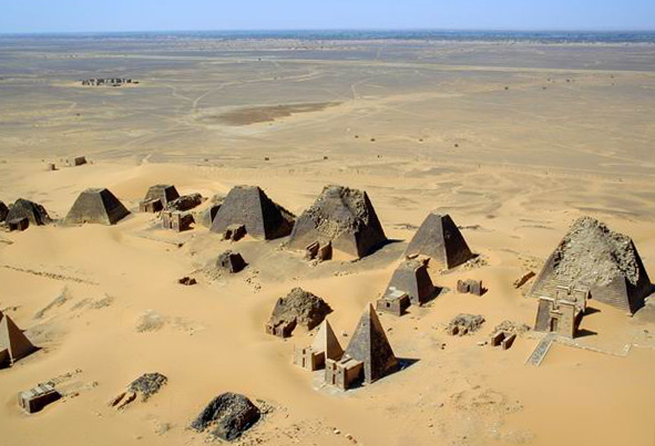
The site of the city of Meroë is marked by more than two hundred pyramids in three groups, of which many are in ruins. They have the distinctive size and proportions of Nubian pyramids.
![W19 [mi] mi](/w/extensions/wikihiero/img/hiero_W19.png?c9d92)
![E23 [rw] rw](/w/extensions/wikihiero/img/hiero_E23.png?e613a)
![M17 [i] i](/w/extensions/wikihiero/img/hiero_M17.png?2e70b)
![V4 [wA] wA](/w/extensions/wikihiero/img/hiero_V4.png?e648c)
![X1 [t] t](/w/extensions/wikihiero/img/hiero_X1.png?f2a8c)
![O49 [niwt] niwt](/w/extensions/wikihiero/img/hiero_O49.png?dd778)
![N25 [xAst] xAst](/w/extensions/wikihiero/img/hiero_N25.png?6f14c)

Meroë was the southern capital of the Kingdom of Kush. The Kingdom of Kush spanned the period c. 800 BC – c. 350 AD but, initially, its main capital was farther north at Napata.[2] King Aspelta moved the capital to Meroë, considerably farther south than Napata, possibly c. 591 BC,[3] just after the sack of Napata by Egyptian Pharaoh Psamtik II.
Martin Meredith states the Kushite rulers chose Meroë, between the Fifth and Sixth Cataracts, because it was on the fringe of the summer rainfall belt, and the area was rich in iron ore and hardwood for iron working. The location also afforded access to trade routes to the Red Sea. The city of Meroë was located along the middle Nile which is of much importance due to the annual flooding of the Nile river valley and the connection to many major river systems such as the Niger which aided with the production of pottery and iron characteristic to the Meroitic kingdom that allowed for the rise in power of its people.[4] According to partially deciphered Meroitic texts, the name of the city was Medewi.
First Meroitic Period (542–315 BC)The Kings ruled over Napata and Meroë. The seat of government and the royal palace were in Meroe. The Main temple of Amun is located in Napata, but the temple at Meroe is under construction. Kings and many queens are buried in Nuri, some queens are buried in Meroe, in the West Cemetery.[5] The earliest king is Analmaye (542–538 BC), the latest king of the first phase is Nastasen (335–315 BC)
In the fifth century BC, Greek historian Herodotus described it as "a great city...said to be the mother city of the other Ethiopians."[6][7]
Excavations revealed evidence of important, high ranking Kushite burials, from the Napatan Period (c. 800 – c. 280 BC) in the vicinity of the settlement called the Western cemetery. The importance of the town gradually increased from the beginning of the Meroitic Period, especially from the reign of Arakamani (c. 280 BC) when the royal burial ground was transferred to Meroë from Napata (Gebel Barkal). Royal burials formed the Pyramids of Meroë, containing the burials of the Kings and Queens of Meroë from ca 300 BC to about 350 AD.[8]

Karkamani's pyramid (513–503 BC), Nuri

Jewelry found on the mummy of Nubian King Amaninatakilebte (538–519 BC). Museum of Fine Arts, Boston.

Stela of king Siaspiqa (487–468 BC).

Portrait of King Nastasen (330–310 BC)

The seat of government and the royal palace are in Meroe. Kings and many queens are buried in Meroe, in the South Cemetery. Napata's only importance is the Amun Temple.[5] The first King of the period is Aktisanes (Early 3rd century BC), the last king of the period is Sabrakamani (first half 3rd century BC).
Third Meroitic Period (270 BC – 1st century AD)The seat of government and the royal palace are in Meroe. Kings are buried in Meroe, in the North Cemetery, and Queens in West Cemetery. Napata's only importance is the Amun Temple. Meroe flourishes and many building projects are undertaken.[5] The first king of the period is Arakamani (270–260 BC), the last ruler is Queen Amanitore (mid/late 1st century AD)
Many beautiful artifacts were found in Meroitic tombs from around this time.

Pyramids of Meroë - Northern Cemetery

Queen Shanakdakhete (170–150 BC)

Necklace made of 54 composite human head and ram's head gold pendants with a small carnelian bead between each. Meroitic Period, 270–50 BC

Golden Bracelet found in the tomb of a member of the Royal Family in Gebel Barkal. 250–100 BC

King Natakamani (early 1st century AD)
Rome's conquest of Egypt led to border skirmishes and incursions by Meroë beyond the Roman borders. In 23 BC the Roman governor of Egypt, Publius Petronius, to end the Meroitic raids, invaded Nubia in response to a Nubian attack on southern Egypt, pillaging the north of the region and sacking Napata (22 BC) before returning home. In retaliation, the Nubians crossed the lower border of Egypt and looted many statues (among other things) from the Egyptian towns near the first cataract of the Nile at Aswan. Roman forces later reclaimed many of the statues intact, and others were returned following the peace treaty signed in 22 BC between Rome and Meroë under Augustus and Amanirenas, respectively. One looted head though, from a statue of the emperor Augustus, was buried under the steps of a temple. It is now kept in the British Museum.[9]

The next recorded contact between Rome and Meroë was in the autumn of 61 AD. The Emperor Nero sent a party of Praetorian soldiers under the command of a tribune and two centurions into this country, who reached the city of Meroë where they were given an escort, then proceeded up the White Nile until they encountered the swamps of the Sudd. This marked the limit of Roman penetration into Africa.[10]
The period following Petronius' punitive expedition is marked by abundant trade finds at sites in Meroë. L. P. Kirwan provides a short list of finds from archeological sites in that country.[10]: 18f However, the kingdom of Meroë began to fade as a power by the 1st or 2nd century AD, sapped by the war with Roman Egypt and the decline of its traditional industries.[11]
Meroë is mentioned succinctly in the 1st century AD Periplus of the Erythraean Sea:
2. On the right-hand coast next below Berenice is the country of the Berbers. Along the shore are the Fish-Eaters, living in scattered caves in the narrow valleys. Farther inland are the Berbers, and beyond them the Wild-flesh-Eaters and Calf-Eaters, each tribe governed by its chief; and behind them, farther inland, in the country towards the west, there lies a city called Meroe.


This was the twilight of the Meroitic Culture. Kings were buried in Meroe, in the North Cemetery, and Queens in West Cemetery. In 350 AD Meroe was destroyed by Axum.[5] The first king of the fourth period was Shorkaror (1st century AD), while the last rulers may have been King Yesebokheamani or King Talakhidamani in the 4th century AD.
A stele of Ge'ez of an unnamed ruler of the Kingdom of Aksum thought of as Ezana was found at the site of Meroë; from his description, in Greek, that he was "King of the Aksumites and the Omerites," (i.e. of Aksum and Himyar) it is likely this king ruled sometime around 330.[12] Another inscription in Greek gives the regnal claims of Ezana:[13][14][15]
I, Ezana, King of the Axumites and Himyarites and of Reeidan and of the Sabaites and of Sileel (?) and of Hasa and of the Bougaites and of Taimo...
While some authorities interpret these inscriptions as proof that the Axumites destroyed the kingdom of Meroe, others note that archeological evidence points to an economic and political decline in Meroe around 300.[17] Moreover, some view the stele as military aid from Aksum to Meroe to quell down the revolt and rebellion by the Nuba. However, conclusive evidence and proof to which view is correct is not currently present.
Add new comment