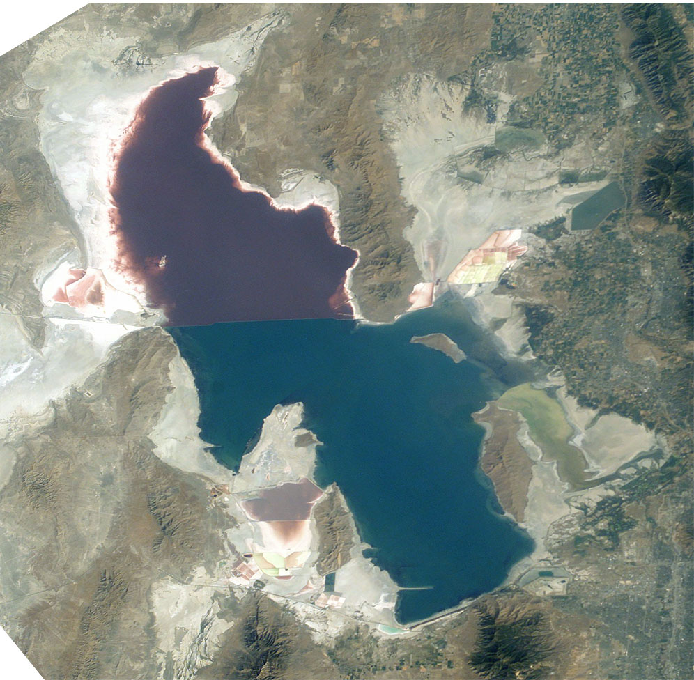
Great Salt Lake

The Great Salt Lake (Shoshone: Ti'tsa-pa “Bad Water”) is the largest saltwater lake in the Western Hemisphere and the eighth-largest terminal lake in the world. It lies in the northern part of the U.S. state of Utah and has a substantial impact upon the local climate, particularly through lake-effect snow. It is a remnant of Lake Bonneville, a prehistoric body of water that covered much of western Utah.

The area of the lake can fluctuate substantially due to its low average depth of 16 feet (4.9 m). In the 1980s, it reached a historic high of 3,300 square miles (8,500 km2), and the West Desert Pumping Project was established to mitigate flooding by pumping water from the lake into the nearby desert. In 2021, after years of sustained drought and increased water diversion upstream of the lake, it fell to its lowest recorded area at 950 square miles (2,500 km2), falling below the previous low set in 1963. C...Read more

The Great Salt Lake (Shoshone: Ti'tsa-pa “Bad Water”) is the largest saltwater lake in the Western Hemisphere and the eighth-largest terminal lake in the world. It lies in the northern part of the U.S. state of Utah and has a substantial impact upon the local climate, particularly through lake-effect snow. It is a remnant of Lake Bonneville, a prehistoric body of water that covered much of western Utah.

The area of the lake can fluctuate substantially due to its low average depth of 16 feet (4.9 m). In the 1980s, it reached a historic high of 3,300 square miles (8,500 km2), and the West Desert Pumping Project was established to mitigate flooding by pumping water from the lake into the nearby desert. In 2021, after years of sustained drought and increased water diversion upstream of the lake, it fell to its lowest recorded area at 950 square miles (2,500 km2), falling below the previous low set in 1963. Continued shrinkage could turn the lake into a bowl of toxic dust, poisoning the air around Salt Lake City.

The lake's three major tributaries, the Jordan, Weber, and Bear rivers together deposit around 1.1 million tons of minerals in the lake per year. Since the lake has no outlet besides evaporation, these minerals accumulate and give the lake high salinity (far saltier than seawater) and density. This density causes swimming in the lake to feel similar to floating.

The lake has been called "America's Dead Sea" and provides a habitat for millions of native birds, brine shrimp, shorebirds, and waterfowl, including the largest staging population of Wilson's phalarope in the world.

 Stansbury's 1852 map of the Great Salt Lake and adjacent country in the Utah Territory

The Shoshone, Ute, and Paiute have lived near the Great Salt Lake for thousands of years. At the time of Salt Lake City's founding, the valley was within the territory of the Northwestern Shoshone;[1] however, occupation was seasonal, near streams emptying from canyons into the Salt Lake Valley. One of the local Shoshone tribes, the Western Goshute tribe, referred to the lake as Pi'a-pa, meaning "big water", or Ti'tsa-pa, meaning "bad water".[2][3]

There are several maps dating back to 1575 that show the Great Salt Lake at the correct latitude and longitude, within an accuracy of a few degrees.[citation needed] One example is a map by Nicolas Sanson dated 1650.[4] The Great Salt Lake entered written history through the records of Silvestre Vélez de Escalante, who learned of its existence from the Timpanogos Utes in 1776. No European name was given to it at the time, and it was not shown on the map by Bernardo Miera y Pacheco, the cartographer for the expedition. Escalante had been on the shores of Utah Lake, which he named Laguna Timpanogos. It was the larger of the two lakes that appeared on Miera's map. Other cartographers followed his lead and charted Lake Timpanogos as the largest (or larger) lake in the region. As people became aware of the Great Salt Lake, they interpreted the maps to think that "Timpanogos" referred to the Great Salt Lake. On some maps, the two names were used synonymously. In time, "Timpanogos" was dropped from the maps and its original association with Utah Lake was forgotten.

In 1824, it was observed, apparently independently, by Jim Bridger and Etienne Provost. Shortly thereafter, other trappers saw it and walked around it. Most of the trappers, however, were illiterate and did not record their discoveries. As oral reports of their findings made their way to those who did make records, some errors were made. In 1843, John C. Fremont led the first scientific expedition to the lake, but with winter coming on, he did not take the time to survey the entire lake. That happened in 1850 under the leadership of Howard Stansbury (Stansbury discovered and named the Stansbury mountain range and Stansbury island).[5] John Fremont's overly glowing reports of the area were published shortly after his expedition. Stansbury also published a formal report of his survey work which became very popular. His report of the area included a discussion of Mormon religious practices based on Stansbury's interaction with the Mormon community in Great Salt Lake City, which had been established three years earlier in 1847.[6]

Beginning in November 1895, artist and author Alfred Lambourne spent a year living on the remote Gunnison Island, where he wrote a book of musing and poetry, Our Inland Sea. From November 1895 to March 1896, he was alone. In March, a few guano sifters arrived to harvest and sell the guano of the nesting birds as fertilizer. Lambourne included musings about these guano sifters in his work. Lambourne left the island early in the winter of 1896 along with the first group of guano sifters.[7]

1930s Fresh Water Project

In the early 1930s, there was a project to dam off a third of the lake with dikes on the east side north of Salt Lake City to make a freshwater reservoir for drinking and irrigation. The project was abandoned before it got beyond the planning stage.[8]

Causeway

The causeway across the lake was built in the 1950s by the Morrison-Knudsen construction company for the Southern Pacific Railroad as a replacement to a previously built wooden trestle, which was the major component of the Lucin Cutoff. The route is now owned and operated by Union Pacific.[9] About 15 trains cross the 20 mi (32 km) causeway each day.[10] Prior to December 2, 2016, the causeway constrained the flow of water between northern and southern arms, which has a significant impact on various industries surrounding the lake. The construction of a 180-foot-long (55 m) bridge created an opening of the causeway for water to flow between the arms of the lake.

Willard Bay Reservoir

Willard Bay, also known as Willard Bay Reservoir or Arthur V. Watkins Reservoir, is a freshwater reservoir completed in 1964, which separated, drained, and subsequently filled with fresh water from the Weber River a portion of the Great Salt Lake's northeastern arm.

West Desert Pumping Project

Record high water levels in the 1980s caused a large amount of property damage for owners on the eastern side of the Great Salt Lake, and the water started to erode the base of Interstate 80. In response, the State of Utah built the West Desert Pumping Project on the western side of the lake. It began operation on April 10, 1987. This project consists of a pumping station (41°15′9.28″N 113°4′53.31″W / 41.2525778°N 113.0814750°W / 41.2525778; -113.0814750) at Hogup Ridge, containing three pumps with a combined capacity of moving 1,500,000 US gallons per minute (95 m3/s), an inlet canal, and an outlet canal. Also, there are 25 miles (40 km) of dikes and a 10-mile (16 km) access road between the town of Lakeside and the pumping station.[11]

This pumping project was designed to increase the surface area of the Great Salt Lake and thus increase the rate of water evaporation. The pumps drove some of the water of the Great Salt Lake into the 320,000 acres (1,300 km2) Newfoundland Evaporation Basin in the desert west of the lake. A weir in the dike at the southern end of the Newfoundland Mountains regulated the level of water in the basin and it sometimes returned salty water from the evaporation basin into the main body of the Great Salt Lake.[11]

At the end of their first year of operation, the pumps had removed about 500,000 acre-feet (620,000,000 m3) of water from the Great Salt Lake. The project was shut down in June 1989, as the level of the lake had dropped by nearly six feet (1.8 meters) since reaching its peak levels during June 1986 and March 1987. The Utah Division of Water Resources credits the project with "over one-third of that decline".[11] In total, the pumps removed 2,730,000 acre-feet (3.37 km3) of water while they operated.[12]

Although the pumps are no longer in use, they have been kept in place in case the level of the Great Salt Lake ever rises that high again.[13]

Shrinking

Drought conditions, climate change, and the overuse of snowmelt have caused the Great Salt Lake to shrink considerably.[14] As of July 2022, the Great Salt Lake occupies approximately 950 square miles (2,500 km2).[14][15] In 1987, it occupied about 3,300 square miles (8,500 km2).[14] As of March 2023, the lake's highest recorded surface elevation was 4,211.2 feet (1,283.6 m) For comparision, on April 15, 1987; the lowest recorded surface elevation was 4,188.5 feet (1,276.7 m) on December 17, 2022.[16] In 2023, scientists at Brigham Young University estimated that without policy changes, the lake would dry up in 2028, with local species killed off by overly salty water somewhat before that.[17][18]

Environmentalists proposed establishing a level of 4,200 ft (1,300 m) above sea level as an official state policy, among other interventions.[19] University of Utah researchers[20] proposed a level between 4,198 and 4,205 feet.[21] A non-binding resolution in the state legislature to adopt 4,198 feet was voted down and governor Spencer Cox called it "dumb".[21]

^ Madsen, Brigham (1985). The Shoshoni Frontier and the Bear River Massacre. University of Utah Press. p. 6. ISBN 978-0-87480-494-2. ^ Chamberlin, Ralph V. (1913). "Place and Personal Names of the Gosiute Indians of Utah, Page 12". Proceedings of the American Philosophical Society. 52 (208): 1–20. JSTOR 983995. ^ Chamberlin, Ralph V. (1913). "Place and Personal Names of the Gosiute Indians of Utah, Page 9". Proceedings of the American Philosophical Society. 52 (208): 1–20. JSTOR 983995. ^ File:Insel Kalifornien 1650.jpg ^ Encyclopedia Britannica. Vol. 10. 1971. ^ Stansbury, Howard (1852). Exploration and survey of the valley of the Great Salt Lake of Utah. Lippincott, Grambo & Co. p. 1. Retrieved January 23, 2010. stansbury survey great salt lake. ^ Carter, Lyndia (June 1996). "Guano Sifters on Gunnison Island". History Blazer. Utah State Historical Society. Archived from the original on October 16, 2013. Retrieved October 30, 2013. ^ "Aim To Change Great Salt Lake Into Fresh Water". Popular Science. May 1932. ^ Hollenhorst, John. "Union Pacific causeway upgrade proposal could change colors of the Great Salt Lake". Deseret News. Archived from the original on October 29, 2013. Retrieved November 21, 2012. ^ Cite error: The named reference SLTrib Causeway was invoked but never defined (see the help page). ^ a b c Hassible & Keck (1993), p. 22. ^ "Fact Sheet: West Desert Pumping Project". Utah Division of Water Resources. Archived from the original on August 27, 2013. Retrieved August 23, 2006. ^ "Great Salt Lake Pumping Project". Utah Division of Water Resources. Archived from the original on August 27, 2013. Retrieved August 9, 2006. ^ a b c Yeung, Peter (July 8, 2022). "Salt Lake City Confronts a Future Without a Lake". Bloomberg.com. Retrieved July 14, 2022. ^ Carlowicz, Michael (August 18, 2021). "Record Low for Great Salt Lake". NASA Earth Observatory. ^ "USGS Great Salt Lake Hydro Mapper". webapps.usgs.gov. Retrieved March 2, 2023. ^ "Climate change and a population boom could dry up the Great Salt Lake in 5 years". NPR. Archived from the original on June 3, 2023. ^ Abbott, Benjamin; et al. "Emergency measures needed to rescue Great Salt Lake from ongoing collapse". Retrieved July 30, 2023. ^ Utah Rivers Council (2023). "The 4200 Guidebook - An advocacy manual to raise the Great Salt Lake to a sustainable level for future generations of Americans" (PDF). ^ Great Salt Lake Strike Team ^ a b Saige Miller (October 27, 2023). "Last winter was good to Great Salt Lake, but Utah Rivers Council says more can be done". KUER.
Photographies by:
Statistics: Position
483
Statistics: Rank
179696

Add new comment

Esta pregunta es para comprobar si usted es un visitante humano y prevenir envíos de spam automatizado.

Security
158934627Click/tap this sequence: 7119

Google street view

Where can you sleep near Great Salt Lake ?

Booking.com
490.013 visits in total, 9.198 Points of interest, 404 Destinations, 62 visits today.