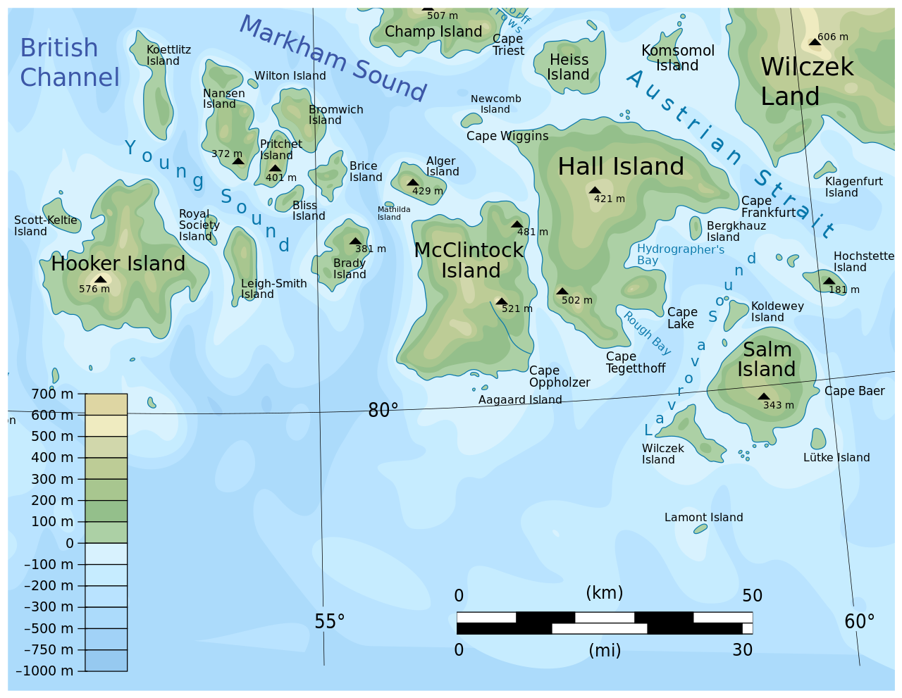
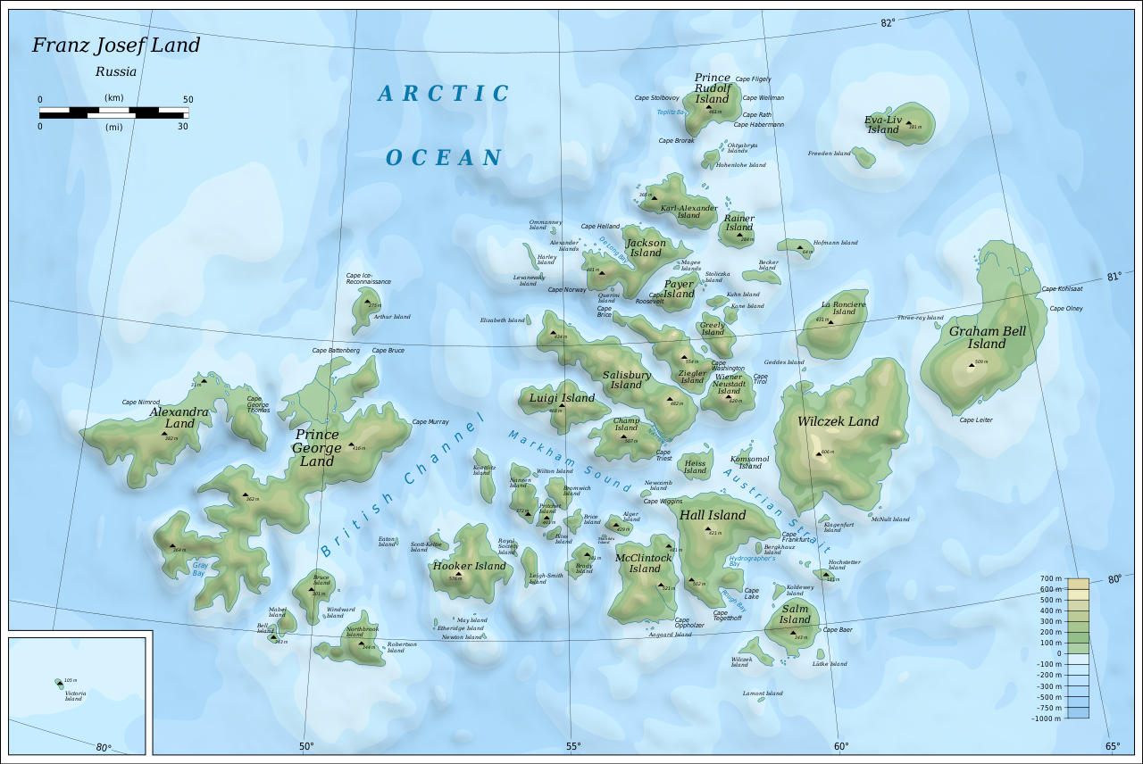
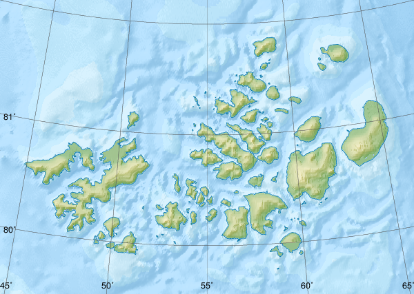
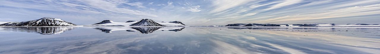
Земля Франца-Иосифа

( Franz Josef Land )

Franz Josef Land (Russian: Земля́ Фра́нца-Ио́сифа, romanized: Zemlya Frantsa-Iosifa; Norwegian: Fridtjof Nansen Land) is a Russian archipelago in the Arctic Ocean. It is inhabited only by military personnel. It constitutes the northernmost part of Arkhangelsk Oblast and consists of 192 islands, which cover an area of 16,134 square kilometers (6,229 sq mi), stretching 375 kilometers (233 mi) from east to west and 234 kilometers (145 mi) from north to south. The islands are categorized in three groups (western, central, and eastern) separated by the British Channel and the Austrian Strait. The central group is further divided into a northern and southern section by the Markham Sound. The largest island is Prince George Land, which measures 2,741 square kilometers (1,058 sq mi), followed by Wilczek Land, Graham Bell Island and Alexandra Land.

App...Read more

Franz Josef Land (Russian: Земля́ Фра́нца-Ио́сифа, romanized: Zemlya Frantsa-Iosifa; Norwegian: Fridtjof Nansen Land) is a Russian archipelago in the Arctic Ocean. It is inhabited only by military personnel. It constitutes the northernmost part of Arkhangelsk Oblast and consists of 192 islands, which cover an area of 16,134 square kilometers (6,229 sq mi), stretching 375 kilometers (233 mi) from east to west and 234 kilometers (145 mi) from north to south. The islands are categorized in three groups (western, central, and eastern) separated by the British Channel and the Austrian Strait. The central group is further divided into a northern and southern section by the Markham Sound. The largest island is Prince George Land, which measures 2,741 square kilometers (1,058 sq mi), followed by Wilczek Land, Graham Bell Island and Alexandra Land.

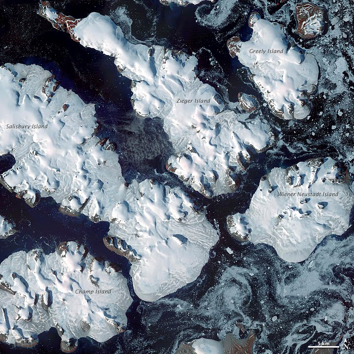
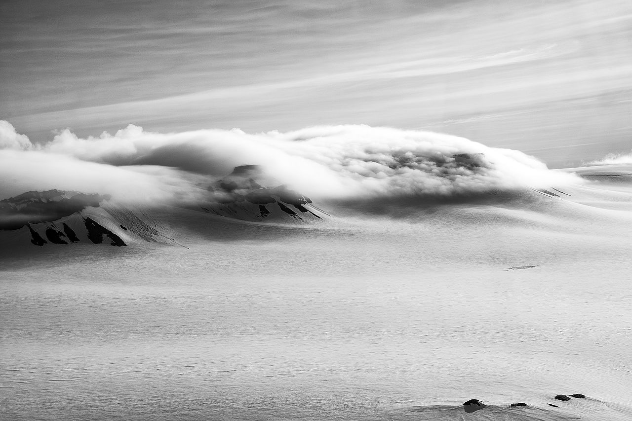
Approximately 85% of the archipelago is glaciated, with large unglaciated areas on the largest islands and many of the smallest ones. The islands have a combined coastline of 4,425 kilometers (2,750 mi). Compared to other Arctic archipelagos, Franz Josef Land is highly dissected, as a result of its being heavy glaciated, with a very low ratio of total area to coastline of just ~3.6 square kilometers per coastline kilometer. Cape Fligely on Rudolf Island is the northernmost point of the Eastern Hemisphere. The highest elevations are found in the eastern group, with the highest point located on Wiener Neustadt Land, 670 meters (2,200 ft) above mean sea level.

The archipelago was first spotted by the Norwegian sailors Nils Fredrik Rønnbeck and Johan Petter Aidijärvi in 1865, although they did not report their finding. The first reported finding was in the 1873 Austro-Hungarian North Pole expedition led by Julius von Payer and Karl Weyprecht, who named the area after Emperor Franz Joseph I.

In 1926, the Soviet Union annexed the islands, which were known at the time as Fridtjof Nansen Land, and settled small outposts for research and military purposes. The Kingdom of Norway rejected the claim and several private expeditions were sent to the islands. With the Cold War, the islands became off limits for foreigners and two military airfields were built. The islands have been a nature sanctuary since 1994 and became part of the Russian Arctic National Park in 2012.

 Austro-Hungarian North Pole Expedition

There are two candidates for the discovery of Franz Josef Land. The first was the Norwegian sealing vessel Spidsbergen, with captain Nils Fredrik Rønnbeck and harpooner Johan Petter Aidijärvi. They sailed northeast from Svalbard in 1865 searching for suitable sealing sites, and they found land that was most likely Franz Josef Land. The account is believed to be factual, but an announcement of the discovery was never made, and their sighting therefore remained unknown to subsequent explorers. It was at the time common to keep newly discovered areas secret, as their discovery was aimed at exploiting them for sealing and whaling, and exposure would cause competitors to flock to the site.[1] Russian scientist N. G. Schilling proposed in 1865 that the ice conditions in the Barents Sea could only be explained if there was another land mass in the area, but he never received funding for an expedition.[2]

The Austro-Hungarian North Pole Expedition of 1872–74 was the first to announce the discovery of the islands. Led by Julius von Payer and Karl Weyprecht of Austria-Hungary on board the schooner Tegetthoff, the expedition's primary goal was to find the Northeast Passage and its secondary goal to reach the North Pole.[3] Starting in July 1872,[4] the vessel drifted from Novaya Zemlya to a new landmass,[5] which they named in honor of Franz Joseph I (1830–1916), Emperor of Austria.[6] The expedition contributed significantly to the mapping and exploration of the islands. The next expedition to spot the archipelago was the Dutch Expedition for the Exploration of the Barents Sea, on board the schooner Willem Barents. Constrained by the ice, they never reached land.[7]

Polar exploration

Benjamin Leigh Smith's expedition in 1880, aboard the barque Eira, followed a route from Spitsbergen to Franz Josef Land,[7] landing on Bell Island in August. Leigh Smith explored the vicinity and set up a base at Eira Harbour, before exploring towards McClintock Island. He returned the following year in the same vessel, landing at Grey Bay on George Land.[8] The explorers were stopped by ice at Cape Flora, and Eira sank on 21 August. They built a cottage and stayed the winter,[9] to be rescued by the British vessels Kara and Hope the following summer.[10] These early expeditions concentrated their explorations on the southern and central parts of the archipelago.[11]

Two men shake hands in the midst of a snowfield, with a dog sitting nearby. Dark hills are shown in the background. The Nansen–Jackson meeting at Cape Flora, 17 June 1896 (a posed photograph taken hours after the initial meeting)

Nansen's Fram expedition was an 1893–1896 attempt by the Norwegian explorer Fridtjof Nansen to reach the geographical North Pole by harnessing the natural east–west current of the Arctic Ocean. Departing in 1893, Fram drifted from the New Siberian Islands for one and a half years before Nansen became impatient and set out to reach the North Pole on skis with Hjalmar Johansen. Eventually, they gave up on reaching the pole and instead found their way to Franz Josef Land, the nearest land known to man. They were thus able to establish that there was no large landmass north of this archipelago.[12] In the meantime the Jackson–Harmsworth Expedition set off in 1894, set up a base on Bell Island, and stayed for the winter.[11] The following season they spent exploring.[13] By pure chance, at Cape Flora in the spring of 1896, Nansen stumbled upon Frederick George Jackson, who was able to transport him back to Norway.[14] Nansen and Jackson explored the northern, eastern, and western portions of the islands.[11] Once the basic geography of Franz Josef Land had become apparent, expeditions shifted to using the archipelago as a basis to reach the North Pole. The first such attempt was conducted by the National Geographic Society-sponsored American journalist Walter Wellman in 1898.[14] The two Norwegians, Paul Bjørvig and Bernt Bentsen, stayed the winter 1898–9 at Cape Heller on Wilczek Land, but insufficient fuel caused the latter to die.[15] Wellman returned the following year, but the polar expedition itself was quickly abandoned when they lost most of their equipment.[16] Italian nobleman Luigi Amedeo organized the next expedition in 1899, on the Stella Polare.[17] They stayed the winter,[18] and in February and again in March 1900 set out towards the pole, but failed to get far.[19]

 The Stella Polare was trapped and threatened to sink. The crew were obliged to land with the utmost haste and to secure materials for building a dwelling.

Evelyn Baldwin, sponsored by William Ziegler, organized the Ziegler Polar Expedition of 1901. Setting up a base on Alger Island, he stayed the winter exploring the area, but failed to press northwards. The expedition was largely regarded as an utter failure by the exploration and scientific community, which cited the lack of proper management. Unhappy with the outcome, Ziegler organized a new expedition, for which he appointed Anthony Fiala, second-in-command in the first expedition, as leader.[20] It arrived in 1903 and spent the winter. Their ship, America, was crushed beyond repair in December and disappeared in January. Still, they made two attempts towards the pole, both of which were quickly abandoned.[21] They were forced to stay another year, making yet another unsuccessful attempt at the pole, before being evacuated in 1905 by the Terra Nova.[22]

The first Russian expedition was carried out in 1901, when the icebreaker Yermak traveled to the islands.[23] The next expedition, led by hydrologist Georgy Sedov, embarked in 1912 but did not reach the archipelago until the following year because of ice. Among its scientific contributions were the first snow measurements of the archipelago, and the determination that changes of the magnetic field occur in cycles of fifteen years.[24] It also conducted topographical surveys of the surrounding area.[25] Scurvy set in during the second winter, killing a machinist. Despite lacking prior experience or sufficient provisions, Sedov insisted on pressing forward with a march to the pole. His condition deteriorated and he died on 6 March.[26]

 America anchored at Tepliz Bay

Hertha was sent to explore the area, and its captain, I. I. Islyamov hoisted a Russian iron flag at Cape Flora and proclaimed Russian sovereignty over the archipelago. The act was motivated by the ongoing First World War and Russian fears of the Central Powers establishing themselves there. The world's first Arctic flight took place in August 1914, when Polish aviator (one of the first pilots of the Russian Navy) Jan Nagórski overflew Franz Josef Land in search of Sedov's group. Andromeda set out for the same purpose; while failing to locate them, the crew were able to finally determine the non-existence of Peterman Land and King Oscar Land, suspected lands north of the islands.[27]

The Soviet Union

Soviet expeditions were sent almost yearly from 1923.[27] Franz Josef Land had been considered terra nullius – land belonging to no one – but on 15 April 1926 the Soviet Union declared its annexation of the archipelago. Emulating Canada's declaration of the sector principle, they pronounced all land between the Soviet mainland and the North Pole to be Soviet territory. This principle has never been internationally recognized.[28] Both Italy and Norway protested.[27] Norway was first and foremost concerned about its economic interests in the area, in a period when Norwegian hunters and whalers were also being barred from the White Sea, Novaya Zemlya and Greenland; the Soviet government, however, largely remained passive, and did not evict Norwegian hunting ships during the following years. Nor did the Soviets interfere when, in 1926, several foreign ships entered the waters in search of the vanished airship Italia.[28]

Norway attempted both a diplomatic solution and a Lars Christensen-financed expedition to establish a weather station to gain economic control over the islands, but both failed in 1929.[29] Instead the Soviet icebreaker Sedov set out, led by Otto Schmidt, landed in Tikhaya Bay, and began construction of a permanent base.[30] The Soviet government proposed renaming the archipelago Fridtjof Nansen Land in 1930, but the name never came into use.[29] In 1930 the Norwegian Bratvaag Expedition visited the archipelago, but was asked by Soviet authorities to respect Soviet territorial water in the future. Other expeditions that year were the Norwegian-Swedish balloon expedition led by Hans Wilhelmsson Ahlmann on Quest and the German airship Graf Zeppelin.[31] Except for a German weather station emplaced during the Second World War, these were the last Western expeditions to Franz Josef Land until 1990.[32]

Soviet activities grew rapidly following the International Polar Year in 1932. The archipelago was circumnavigated, people landed on Victoria Island, and a topographical map was completed. In 1934–35 geological and glaciological expeditions were carried out, cartographic flights were flown, and up to sixty people stayed the winters between 1934 and 1936, which also saw the first birth. The first drifting ice station was set up out of Rudolf Island in 1936.[33] An airstrip was then constructed on a glacier on the island, and by 1937 the winter population hit 300.[34]

Activity dwindled during the Second World War and only a small group of men were kept at Rudolf Island, remaining unsupplied throughout the war.[35] They never discovered Nazi Germany's establishment of a weather station, named Schatzgräber, on Alexandra Land as part of the North Atlantic weather war. The German station was evacuated in 1944 after the men were struck by trichinosis from eating polar bear meat.[36] Apparent physical evidence of the base was discovered in 2016.[37]

The Cold War produced renewed Soviet interest in the islands because of their strategic military significance. The islands were regarded as an "unsinkable aircraft carrier". The site of the former German weather station was selected as the location of a Soviet aerodrome and military base, Nagurskoye. With the advent of intercontinental ballistic missiles, the Soviet Union changed its military strategy in 1956, abolishing the strategic need for an airbase on the archipelago. The International Geophysical Year of 1957 and 1958 gave a new rise to the scientific interest in the archipelago and an airstrip was built on Heiss Island in 1956. The following year the geophysical Ernst Krenkel Observatory was established there.[35] Activity at Tikhaya Bay was closed in 1959.[38]

Because of the islands' military significance, the Soviet Union closed off the area to foreign researchers, although Soviet researchers carried out various expeditions, including in geophysics, studies of the ionosphere, marine biology, botany, ornithology, and glaciology.[39] The Soviet Union opened up the archipelago for international activities from 1990, with foreigners having fairly straightforward access.[40]

Recent history  Nagurskoye is Russia's northernmost military base

As part of the opening up of Franz Josef Land, the Institute of Geography in Moscow, Stockholm University and Umeå University (Sweden) conducted expeditions to Alexandra Land in August 1990 and August 1991, studying climate- and glacial history by radiocarbon dating raised beaches and antlers from extinct caribou.[41][42][43] The work was conducted from a small research base southwest of Nagurskoye, built in 1989. Also in 1990, a collaboration between the Academy of Sciences, the Norwegian Polar Institute and the Polish Academy of Sciences resulted in the first of several archaeological expeditions organized by the Institute of Culture in Moscow.[40] The military base on Graham Bell Island was abandoned in the early 1990s. The military presence at Nagurskoye was reduced to that of a border post, and the number of people stationed at Krenkel Observatory was reduced from 70 to 12.[44] The archipelago and the surrounding waters were declared a nature reserve in April 1994. The opening of the archipelago also saw the introduction of tourism, most of which takes place on Russian-operated icebreakers.[45] In 2011, in a move to better accommodate tourism in the archipelago, the Russian Arctic National Park was expanded to include Franz Josef Land.[46] However, in August 2019, Russia abruptly withdrew its approval for a Norwegian cruise ship to visit the islands.[47]

In 2012, the Russian Air Force decided to reopen the Graham Bell Airfield as part of a series of reopenings of air bases in the Arctic.[48] A major new base, named the Arctic Trefoil for its three lobed structure, was constructed at Nagurskoye. It can maintain 150 soldiers for 18 months and has an area of 14,000 square meters.[49] The upgraded airbase is considered a threat to the U.S. military installation at Thule, Greenland.[50]

In 2017, Russian president Vladimir Putin visited the archipelago.[51]

In August 2019, a geographic expedition by Russian Northern Fleet discovered several new islands in the archipelago. They were previously buried under Vylki Glacier until part of it melted.[52]

In April 2020, the archipelago was used by the Russian Airborne Forces to perform the world's first high-altitude military parachuting (HALO) paradrop from the lower border of the Arctic stratosphere. The crews of Il-76 aircraft practiced at the northernmost airfield of the country on the island of Franz Josef Land. Not only did the paratroopers endure the partial oxygen of the stratosphere common under the HALO technique; they encountered deep freeze conditions mitigated by military tested oxygen tanks and uniforms. Challenges to the Arctic mission included undirected terrain, in the absence of ground navigation systems. During the end of the mission, the paratroopers spent a day during which they conducted classes on survival in Arctic conditions and built shelters from snow.[53][54][55]

^ Barr (1995): 59 * Barr, Susan (1995). Franz Josef Land. Oslo: Norwegian Polar Institute. ISBN 82-7666-095-9. ^ Barr (1995): 129 ^ Barr (1995): 107 ^ Barr (1995): 110 ^ Barr (1995): 112 ^ Barr (1995): 119 ^ a b Barr (1995): 61 ^ Barr (1995): 62 ^ Barr (1995): 63 ^ Barr (1995): 64 ^ a b c Barr (1995): 65 ^ Barr (1995): 72 ^ Barr (1995): 66 ^ a b Barr (1995): 76 ^ Barr (1995): 78 ^ Barr (1995): 79 ^ Barr (1995): 80 ^ Barr (1995): 81 ^ Barr (1995): 82 ^ Barr (1995): 88 ^ Barr (1995): 90 ^ Barr (1995): 92 ^ Barr (1995): 130 ^ Barr (1995): 131 ^ Barr (1995): 132 ^ Barr (1995): 133 ^ a b c Barr (1995): 134 ^ a b Barr (1995): 95 ^ a b Barr (1995): 96 ^ Barr (1995): 136 ^ Barr (1995): 98 ^ Barr (1995): 100 ^ Barr (1995): 138 ^ Barr (1995): 139 ^ a b Barr (1995): 141 ^ Barr (1995): 101 ^ Russian Scientists Say They've Discovered a Secret Nazi Base in The Arctic ^ Barr (1995): 142 ^ Barr (1995): 144 ^ a b Barr (1995): 104 ^ Glazovskiy, Andrey; Näslund, Jens-Ove; Zale, Rolf (1992). "Deglaciation and shoreline displacement on Alexandra Land, Franz Josef Land". Geografiska Annaler. 74(A) (4): 283–293. doi:10.1080/04353676.1992.11880371. ^ Näslund, Jens-Ove; Zale, Rolf; Glazovskiy, Andrey (1994). "The Mid Holocene transgression on Alexandra Land, Franz Josef Land, Russia". Geografiska Annaler. 76(A) (1–2): 97–101. doi:10.1080/04353676.1994.11880409. ^ Cite error: The named reference :0 was invoked but never defined (see the help page). ^ Barr (1995): 151 ^ Barr (1995): 152 ^ Sazhenova, Anastasia (29 August 2011). "Russia ready to boost Arctic tourism". Barents Observer. ^ Thomas, Nilsen (19 August 2019). "Norwegian cruise ship banned from sailing Franz Josef Land". Barents Observer. ^ Pettersen, Trude (31 May 2012). "Russia reopens Arctic airbases". Barents Observer. ^ Russia Builds Second Military base to Support Arctic Ambitions ^ Cela, Margrét, and Pia Hansson. Geopolitics and Neglected Arctic Spaces: Three Northern Perspectives on Balancing External Interests. Center for Strategic and International Studies (CSIS), 2020. JSTOR website Retrieved 14 Sept. 2023. ^ "Vladimir Putin visits Arctic archipelago and stakes claim to the oil-rich region". The Telegraph. 30 March 2017. ^ Arctic team maps five islands found by Russian student - BBC News ^ "Russian paratroopers for the first time in world history made a landing as part of a group on new parachute systems from an altitude of 10,000 meters in Arctic conditions". Ministry of Defence of the Russian Federation. 26 April 2020. Retrieved 11 June 2020. ^ Humpert, Malte. "Russian Paratroopers Perform First-Ever High Altitude Jump Over Arctic". www.highnorthnews.com. Retrieved 2020-06-11. ^ "ЦАМТО / Новости / Экипажи ВТА обеспечили первое в истории высотное десантирование подразделений ВДВ". armstrade.org. Retrieved 2020-06-11.
Photographies by:
Николай Гернет - CC BY-SA 4.0
Statistics: Position
387
Statistics: Rank
205221

Add new comment

CAPTCHA
Security
147632985Click/tap this sequence: 5945
Esta pregunta es para comprobar si usted es un visitante humano y prevenir envíos de spam automatizado.

Google street view

Where can you sleep near Franz Josef Land ?

Booking.com
491.292 visits in total, 9.211 Points of interest, 405 Destinations, 136 visits today.