Chester is a cathedral city and the county town of Cheshire, England, on the River Dee, close to the England-Wales border. With a population of 79,645 in 2011, it is the most populous settlement of Cheshire West and Chester (a unitary authority which had a population of 329,608 in 2011) and serves as its administrative headquarters. It is also the historic county town of Cheshire and the second-largest settlement in Cheshire after Warrington.
Chester was founded in 79 AD as a "castrum" or Roman fort with the name Deva Victrix during the reign of Emperor Vespasian. One of the main army camps in Roman Britain, Deva later became a major civilian settlement. In 689, King Æthelred of Mercia founded the Minster Church of West Mercia, which later became Chester's first cathedral, and the Angles extended and strengthened the walls to protect the city against the Danes. Chester was one of the last cities in England to fall to the Normans, and Will...Read more
Chester is a cathedral city and the county town of Cheshire, England, on the River Dee, close to the England-Wales border. With a population of 79,645 in 2011, it is the most populous settlement of Cheshire West and Chester (a unitary authority which had a population of 329,608 in 2011) and serves as its administrative headquarters. It is also the historic county town of Cheshire and the second-largest settlement in Cheshire after Warrington.
Chester was founded in 79 AD as a "castrum" or Roman fort with the name Deva Victrix during the reign of Emperor Vespasian. One of the main army camps in Roman Britain, Deva later became a major civilian settlement. In 689, King Æthelred of Mercia founded the Minster Church of West Mercia, which later became Chester's first cathedral, and the Angles extended and strengthened the walls to protect the city against the Danes. Chester was one of the last cities in England to fall to the Normans, and William the Conqueror ordered the construction of a castle to dominate the town and the nearby Welsh border. Chester was granted city status in 1541.
The city walls of Chester are some of the best-preserved in the country and have Grade I listed status. It has a number of medieval buildings, but many of the black-and-white buildings within the city centre are Victorian restorations, originating from the Black-and-white Revival movement. Apart from a 100-metre (330 ft) section, the walls are almost complete. The Industrial Revolution brought railways, canals, and new roads to the city, which saw substantial expansion and development; Chester Town Hall and the Grosvenor Museum are examples of Victorian architecture from this period. Tourism, the retail industry, public administration, and financial services are important to the modern economy. Chester signs itself as Chester International Heritage City on road signs on the main roads entering the city.
Charles Leigh concluded in 1701 that there was probably a British city called Genuina (or Gunia) before the arrival of the Romans.[1]
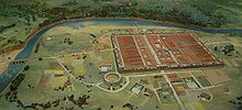
Roman Diorama of the Roman Legionary fortress Deva Victrix in Grosvenor Museum, Chester
The Roman Legio II Adiutrix during the reign of the Emperor Vespasian founded Chester in AD 79, as a "castrum" or Roman fort with the name Deva Victrix. It was established in the land of the Celtic Cornovii, according to ancient cartographer Ptolemy,[2] as a fortress during the Roman expansion northward,[3] and was named Deva either after the goddess of the Dee,[4] or directly from the British name for the river.[5] The 'victrix' part of the name was taken from the title of the Legio XX Valeria Victrix which was based at Deva.[6] Central Chester's four main roads, Eastgate, Northgate, Watergate and Bridgegate, follow routes laid out at this time.
A civilian settlement grew around the military base, probably originating from trade with the fortress.[7] The fortress was 20% larger than other fortresses in the Roman province of Britannia built around the same time at York (Eboracum) and Caerleon (Isca Augusta);[8] this has led to the suggestion that the fortress, rather than London (Londinium), was intended to become the capital of the Roman province of Britannia Superior.[9] The civilian amphitheatre, which was built in the 1st century, could seat between 8,000 and 10,000 people.[10] It is the largest known military amphitheatre in Britain,[11] and is also a Scheduled Monument.[12] The Minerva Shrine in the Roman quarry is the only rock cut Roman shrine still in situ in Britain.[13]
The fortress was garrisoned by the legion until at least the late 4th century.[14] Although the army had abandoned the fortress by 410 when the Romans retreated from Britannia,[15] the Romano-British civilian settlement continued (probably with some Roman veterans staying behind with their wives and children) and its occupants probably continued to use the fortress and its defences as protection from raiders from the Irish Sea.[14]
Medieval Castle Gate, Chester c. 1781
 Chester Castle c. 1781
After the Roman troops withdrew, the Romano-British established a number of petty kingdoms. Chester is thought to have become part of Powys. Deverdoeu was a Welsh name for Chester as late as the 12th century (cf Dyfrdwy, Welsh for the river Dee). Another, attested in the 9th-century History of the Britons traditionally attributed to Nennius, is Cair Legion[16][17][18] ("Fort" or "City of the Legion"); this later developed into Caerlleon and then the modern Welsh Caer. (The town's importance is noted by its taking the simpler form in each case, while Isca Augusta in Monmouthshire, another important legionary base, was known first as Caerleon on the Usk, and now as Caerleon). King Arthur is said to have fought his ninth battle at the "city of the legions" (Caerlleon) and later St Augustine came to the city to try to unite the church, and held his synod with the Welsh Bishops.
In 616, Æthelfrith of Northumbria defeated a Welsh army at the brutal and decisive Battle of Chester, and probably established the Anglo-Saxon position in the area from then on.[citation needed] The Northumbrian Anglo-Saxons used an Old English equivalent of the British name, Legacæstir, which was current until the 11th century, when, in a further parallel with Welsh usage, the first element fell out of use and the simple name Chester emerged. In 689, King Æthelred of Mercia founded the Minster Church of West Mercia on what is considered to be an early Christian site: it is known as the Minster of St John the Baptist, Chester (now St John's Church) which later became the first cathedral. Much later, the body of Æthelred's niece, St Werburgh, was removed from Hanbury in Staffordshire in the 9th century and, to save it from desecration by Danish marauders, was reburied in the Church of SS Peter & Paul – later to become the Abbey Church (the present cathedral). Her name is still remembered in St Werburgh's Street which passes alongside the cathedral, and near the city walls.[citation needed]
The Anglo-Saxons extended and strengthened the walls of Chester to protect the city against the Danes, who occupied it for a short time until Alfred seized all the cattle and laid waste the surrounding land to drive them out. It was Alfred's daughter Æthelflæd, Lady of the Mercians, that built the new Anglo-Saxon burh.[citation needed] A new Church dedicated to St Peter alone was founded in AD 907 by the Lady Æthelfleda at what was to become the Cross. In 973, the Anglo-Saxon Chronicle records that, two years after his coronation at Bath, King Edgar of England came to Chester where he held his court in a palace in a place now known as Edgar's Field near the old Dee bridge in Handbridge. Taking the helm of a barge, he was rowed the short distance up the River Dee from Edgar's Field to the great Minster Church of St John the Baptist by six (the monk Henry Bradshaw records he was rowed by eight kings) tributary kings called reguli.[citation needed]
In 1071, King William the Conqueror[19][20] made Hugh d'Avranches, who built Chester Castle, the first Earl of Chester (second creation). From the 14th century to the 18th century the city's prominent position in North West England meant that it was commonly also known as Westchester. This name was used by Celia Fiennes when she visited the city in 1698.[21] and is also used in Moll Flanders.
Early modern periodIn the English Civil War, Chester sided with the royalist cause of King Charles I, but was subdued by the Parliamentarians in 1643. The Mayor of Chester, Charles Walley, was removed from office and replaced by Alderman William Edwards. Another alderman, Francis Gamull, a royalist MP and former Mayor, was ordered to surrender Dee Mills: they were to be demolished, and new mills built on city land.[22]
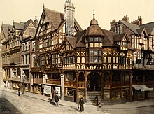
Industrial history Photochrom of the Chester Rows as seen from the Cross, 1895
Chester played a significant part in the Industrial Revolution which began in the North West of England in the latter part of the 18th century. The city village of Newtown, located north east of the city and bounded by the Shropshire Union Canal was at the very heart of this industry.[23] The large Chester Cattle Market and the two Chester railway stations, Chester General and Chester Northgate Station, meant that Newtown with its cattle market and canal, and Hoole with its railways were responsible for providing the vast majority of workers and in turn, the vast amount of Chester's wealth production throughout the Industrial Revolution.
The population was 23,115 by 1841.[24]
Modern era The Falcon Inn after restoration
A considerable amount of land in Chester is owned by The 7th Duke of Westminster who owns an estate, Eaton Hall, near the village of Eccleston. He also has London properties in Mayfair.
Grosvenor is the Duke's family name, which explains such features in the city as the Grosvenor Bridge, the Grosvenor Hotel, and Grosvenor Park. Much of Chester's architecture dates from the Victorian era, many of the buildings being modeled on the Jacobean half-timbered style and designed by John Douglas, who was employed by the Duke as his principal architect.[citation needed] He had a trademark of twisted chimney stacks, many of which can be seen on the buildings in the city centre.
Douglas designed amongst other buildings the Grosvenor Hotel and the City Baths. In 1911, Douglas' protégé and city architect James Strong designed the then active fire station on the west side of Northgate Street. Another feature of all buildings belonging to the estate of Westminster is the 'Grey Diamonds' – a weaving pattern of grey bricks in the red brickwork laid out in a diamond formation.[citation needed]
Towards the end of World War II, a lack of affordable housing meant many problems for Chester. Large areas of farmland on the outskirts of the city were developed as residential areas in the 1950s and early 1960s, producing, for instance, the suburb of Blacon. In 1964, a bypass was built through and around the city centre to combat traffic congestion.[citation needed]
These new developments caused local concern as the physicality[clarification needed] and therefore the feel of the city was being dramatically altered. In 1968, a report by Donald Insall in collaboration with authorities and government recommended that historic buildings be preserved in Chester.[25] Consequently, the buildings were used in new and different ways instead of being demolished.[26]
In 1969, the City Conservation Area was designated. Over the next 20 years the emphasis was placed on saving historic buildings, such as The Falcon Inn, Dutch Houses and Kings Buildings.
On 13 January 2002, Chester was granted Fairtrade City status. This status was renewed by the Fairtrade Foundation on 20 August 2003.[citation needed]


Add new comment