The Vienna Ring Road (German: Ringstraße, pronounced [ʁɪŋˌʃtʁaːsə] , lit. ring road) is a 5.3 km (3.3 mi) circular grand boulevard that serves as a ring road around the historic Innere Stadt (Inner Town) district of Vienna, Austria. The road is located on sites where medieval city fortifications once stood, including high walls and the broad open field ramparts (glacis), criss-crossed by paths that lay before them.
It was constructed after the dismantling of the city walls in the mid-19th century. From the 1860s to 1890s, many large public buildings were erected along the Ringstrasse in an eclectic historicist style, sometimes called Ringstraßenstil ("Ring Road style"), using elements of Classical, Gothic, Renaissance, and Baroque architecture.
Because of ...Read more
The Vienna Ring Road (German: Ringstraße, pronounced [ʁɪŋˌʃtʁaːsə] , lit. ring road) is a 5.3 km (3.3 mi) circular grand boulevard that serves as a ring road around the historic Innere Stadt (Inner Town) district of Vienna, Austria. The road is located on sites where medieval city fortifications once stood, including high walls and the broad open field ramparts (glacis), criss-crossed by paths that lay before them.
It was constructed after the dismantling of the city walls in the mid-19th century. From the 1860s to 1890s, many large public buildings were erected along the Ringstrasse in an eclectic historicist style, sometimes called Ringstraßenstil ("Ring Road style"), using elements of Classical, Gothic, Renaissance, and Baroque architecture.
Because of its architectural beauty and history, the Vienna Ringstrasse has been called the "Lord of the ring roads" and is designated by UNESCO as part of Vienna's World Heritage Site.
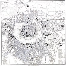 City plan of Vienna (or Wien in German) in 1858, showing the context before construction of the ring boulevard and location of former city walls and glacis surrounding the inner city
This grand boulevard was built to replace the city walls, which had been built during the 13th century and funded by the ransom payment derived from the release of Richard the Lion Heart, Richard I of England, and reinforced as a consequence of the First Turkish Siege in 1529 and the Thirty Years' War in 1618.[1] The walls were surrounded by a glacis about 500m wide, where buildings and vegetation were prohibited for military defensive reason. But by the late 18th century these fortifications had become obsolete. Under Emperor Joseph II, streets and walkways were built in the glacis, lit by lanterns and lined by trees.[2] Craftsmen built open-air workshops, and stalls were set up. But the Revolution of 1848 was required to trigger a more significant change.
 The Schottenring section of the Ringstraße in 1875
In 1850, the suburbs or Vorstädte (today the Districts II to IX) were incorporated into the municipality, which made the city walls an impediment to traffic. In 1857, Emperor Franz Joseph I of Austria issued the decree "I have resolved to command" (Es ist Mein Wille at Wikisource) ordering the demolition of the city walls and moats. In his decree, he laid out the exact size of the boulevard, as well as the geographical positions and functions of the new buildings. The Ringstraße and the planned buildings were intended to be a showcase for the grandeur and glory of the Habsburg Empire. On the practical level, Emperor Napoléon III of France's boulevard construction in Paris had already demonstrated how enlarging and widening the size of streets effectively made the erection of revolutionary barricades difficult and thus an easier target for artillery.
Since the Ringstraße had always been meant primarily for show, a parallel Lastenstraße (cargo road) was built on the outside of the former glacis. This street is commonly known as 2-er Linie, named after the number "2" in the identifiers of the various streetcar or tram lines which used it. It is still an important traffic thoroughfare.
After some disputes about competence between the government and the municipality, a "City Extension Fund" was created, which was administered by the government. Only the city hall was planned by the city.
During the following years, a large number of opulent public and private buildings were erected. Both the nobility and the plutocracy rushed to build showy mansions and palaces along the boulevard. One of the first buildings was the Heinrichshof, owned by the beer brewer Heinrich Drasche, which was located opposite the Imperial and Royal Court Opera House or opera house until 1945.
One of the earliest art historians to study the Ringstraße is Renate Wagner-Rieger, a professor and alumnus at the University of Vienna.


Add new comment