Sagalassos (Greek: Σαγαλασσός), also known as Selgessos (Greek: Σελγησσός) and Sagallesos (Greek: Σαγαλλησός), is an archaeological site in southwestern Turkey, about 100 km north of Antalya (ancient Attaleia) and 30 km from Burdur and Isparta. The ancient ruins of Sagalassos are 7 km from Ağlasun (as well as being its namesake) in the province of Burdur, on Mount Akdağ, in the Western Taurus mountains range, at an altitude of 1450–1700 metres. In Roman Imperial times, the town was known as the "first city of Pisidia", a region in the western Taurus mountains, currently known as the Turkish Lakes Region. During the Hellenistic period it was already one of the major Pisidian towns.
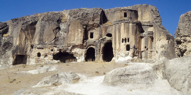
 Heroön in the northwest sector
Human settlement in the area goes back to 8000 BCE, before the actual site was occupied. Hittite documents refer to a mountain site of Salawassa in the fourteenth century BCE and the town spread during the Phrygian and Lydian cultures. Sagalassos was part of the region of Pisidia in the western part of the Taurus Mountains. During the Persian period, Pisidia became known for its warlike factions.
Sagalassos was one of the wealthiest cities in Pisidia when Alexander the Great conquered it in 333 BCE on his way to Persia. It had a population of a few thousand. After Alexander's death, the region became part of the territories of Antigonus Monophthalmus, possibly Lysimachus of Thrace, the Seleucids of Syria and the Attalids of Pergamon. The archeological record indicates that locals rapidly adopted Hellenic culture.
 Head of Demeter, Roman Imperial period, 2nd century CE
The Roman Empire absorbed Pisidia after the Attalids and it became part of the province of Asia. In 39 BCE it was handed out to Galatian client king Amyntas, but after he was killed in 25 BCE Rome turned Pisidia into the province of Galatia. Under the Roman Empire, Sagalassos became the important urban center of Pisidia, particularly favoured by the Emperor Hadrian, who named it the "first city" of the province and the center of the imperial cult. Contemporary buildings have a fully Roman character.
Around 400 CE Sagalassos was fortified for defence. An earthquake devastated it in 518 and a plague circa 541–543 halved the local population. Arab raids threatened the town around 640 and after another earthquake destroyed the town in the middle of the seventh century, the site was abandoned. The populace probably resettled in the valley. Excavations have found only signs of a fortified monastery—possibly a religious community, which was destroyed in the twelfth century. Sagalassos disappeared from the records.
In the following centuries, erosion covered the ruins of Sagalassos. It was not looted to a significant extent, possibly because of its location.
Explorer Paul Lucas, who was traveling in Turkey on a mission for the court of Louis XIV of France, visited the ruins in 1706. After 1824, when Francis Vyvyan Jago Arundell (1780–1846), the British chaplain at Smyrna and an antiquarian, visited the site and deciphered its name in inscriptions,[1] Western travelers began to visit the ruins. Polish historian of art, count K. Lanckoroński produced the first map of Sagalassos. However, the city did not attract much archaeological attention until 1985, when an Anglo-Belgian team led by Stephen Mitchell began a major survey of the site.


Add new comment