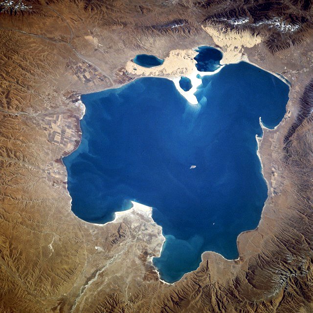
青海湖

( Qinghai Lake )

Qinghai Lake or Ch'inghai Lake, also known by other names, is the largest lake in China. Located in an endorheic basin in Qinghai Province, to which it gave its name, Qinghai Lake is classified as an alkaline salt lake. The lake has fluctuated in size, shrinking over much of the 20th century but increasing since 2004. It had a surface area of 4,317 km2 (1,667 sq mi), an average depth of 21 m (69 ft), and a maximum depth of 25.5 m (84 ft) in 2008.

 Map including Qinghai Lake

During the Han Dynasty (206 BCE–220 CE), substantial numbers of Han Chinese lived in the Xining valley to the east.[1] In the 17th century, Mongolic-speaking Oirat and Khalkha tribals migrated to Qinghai and became known as Qinghai Mongols.[2] In 1724, the Qinghai Mongols led by Lobzang Danjin [nl] revolted against the Qing Dynasty. The Yongzheng Emperor, after putting down the rebellion, stripped away Qinghai's autonomy and imposed direct rule. Although some Tibetans lived around the lake, the Qing maintained an administrative division from the time of Güshi Khan between the Dalai Lama's western realm (slightly smaller than the current Tibet Autonomous Region) and the Tibetan-inhabited areas in the east. Yongzheng also sent Manchu and Han settlers to dilute the Mongols.[3]

During Nationalist rule (1928-1949), the Han formed a majority of Qinghai Province's residents, although Chinese Muslims (Hui) dominated the government.[4] The Kuomintang Hui general Ma Bufang, having invited Kazakh Muslims,[5] joined the governor of Qinghai and other high ranking Qinghai and national government officials in conducting a joint Kokonuur Lake Ceremony to worship the God of the Lake. During the ritual, the Chinese national anthem was sung and all participants bowed to a Portrait of Kuomintang founder Sun Yat-sen as well as to the God of the Lake. Participants, both Han and Muslim, made offerings to the god.[6]

 View of Qinghai Lake, 2016

After the 1949 Chinese revolution, refugees from the 1950s Anti-Rightist Movement settled in the area west of Qinghai Lake.[1] After the Chinese economic reform in the 1980s, drawn by new business opportunities, migration to the area increased, causing ecological stresses. Fresh grass production in Gangcha County north of the lake declined from a mean of 2,057 kilograms per hectare (1,835 lb/acre) to 1,271 kg/ha (1,134 lb/acre) in 1987. In 2001, the State Forestry Administration of China launched the "Retire Cropland, Restore Grasslands" (退耕,还草) campaign and started confiscating Tibetan and Mongol pastoralists' guns in order to preserve the endangered Przewalski's gazelle.[1]

Prior to the 1960s, 108 freshwater rivers emptied into the lake. As of 2003, 85% of the river mouths have dried up, including the lake's largest tributary, the Buha River. In between 1959 and 1982, there had been an annual water level drop of 10 centimeters (3.9 in), which was reversed at a rate of 10 cm/year (3.9 in/year) between 1983 and 1989, but has continued to drop since. The Chinese Academy of Sciences reported in 1998 the lake was again threatened with loss of surface area due to livestock over-grazing, land reclamations, and natural causes.[7] Surface area decreased 11.7% in the period from 1908 to 2000.[8] During that period, higher lake floor areas were exposed and numerous water bodies separated from the rest of the main lake. In the 1960s, the 48.9-square-kilometer (18.9 sq mi) Gahai Lake (尕海, Gǎhǎi) appeared in the north; Shadao Lake (沙岛, Shādǎo), covering an area of 19.6 km2 (7.6 sq mi) to the northeast, followed in the 1980s, along with Haiyan Lake (海晏, Hǎiyàn) of 112.5 km2 (43.4 sq mi).[9] Another 96.7 km2 (37.3 sq mi) daughter lake split off in 2004. In addition, the lake has now split into half a dozen more small lakes at the border. Qinghai Provincial Remote Sensing Center, attributed the separation of Qinghai Lake to shrinkage of the water surface as a result of a lowered water level and desertification in the region. The water surface has shrunk by 312 km2 (120 sq mi) over the last three decades.[10]

^ a b c Harris (2008), pp. 130–132. ^ Sanders (2010), pp. 2–3, 386, 600. ^ Perdue (2005), pp. 310–312. ^ Hutchings (2003), p. 351. ^ Uradyn Erden Bulag (2002). Dilemmas The Mongols at China's edge: history and the politics of national unity. Rowman & Littlefield. p. 52. ISBN 978-0-7425-1144-6. Retrieved 2010-06-28. ^ Uradyn Erden Bulag (2002), p. 51. ^ "China's Qinghai Lake drying up". World Tibet Network News. March 27, 1998. Archived from the original on May 29, 2004. Retrieved May 29, 2004. ^ People's Daily. Archived 2016-11-11 at the Wayback Machine ^ "Two New Saltwater Lakes Separate from Qinghai Lake". fpeng.peopledaily.com. 2001-10-26. Archived from the original on 2003-11-07. ^ Qinghai Lake splits due to deterioration. Chinadaily.com.cn (2004-02-24). Retrieved on 2010-09-27.
Photographies by:
Jucember - CC BY-SA 3.0
Statistics: Position
1995
Statistics: Rank
62281

Add new comment

Esta pregunta es para comprobar si usted es un visitante humano y prevenir envíos de spam automatizado.

Security
625378194Click/tap this sequence: 3188

Google street view

Where can you sleep near Qinghai Lake ?

Booking.com
489.956 visits in total, 9.198 Points of interest, 404 Destinations, 5 visits today.