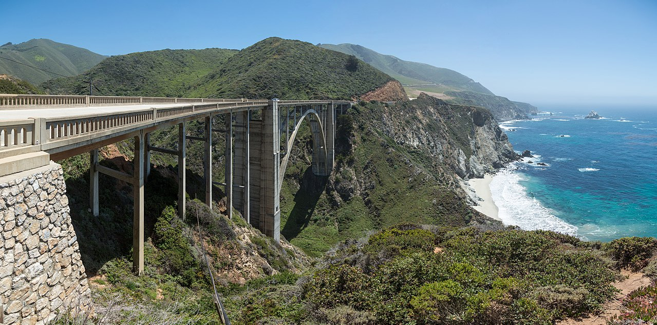
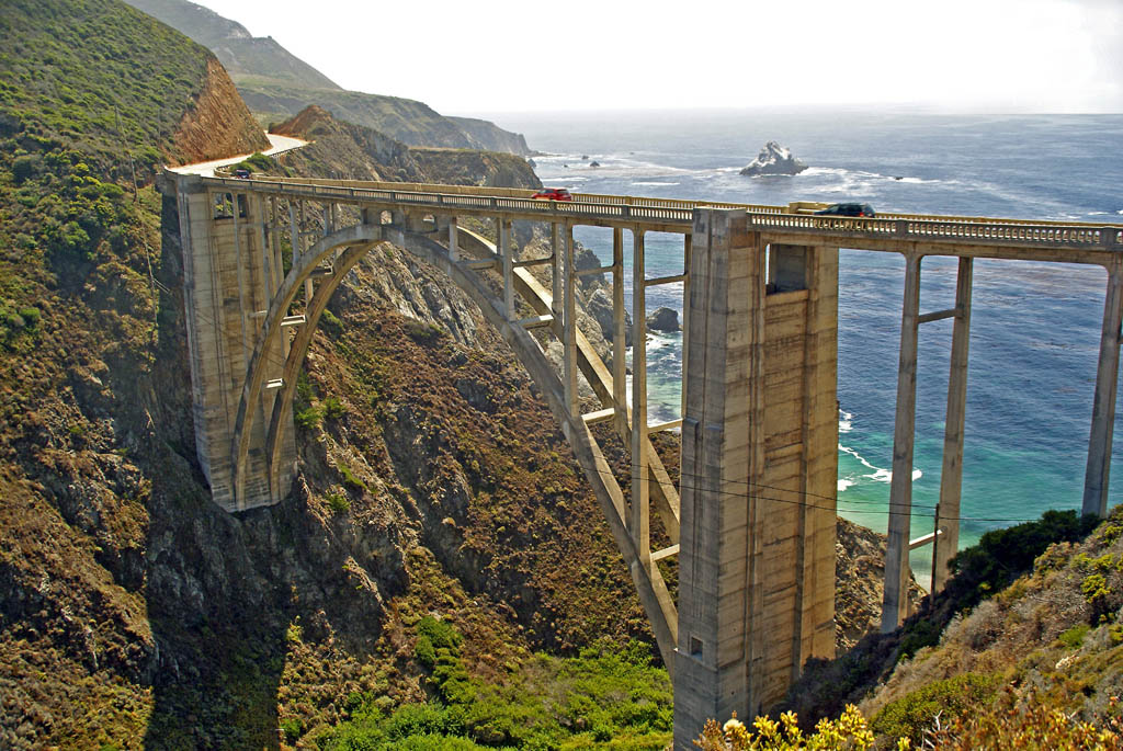
Bixby Bridge, also known as Bixby Creek Bridge, on the Big Sur coast of California, is one of the most photographed bridges in California due to its aesthetic design, "graceful architecture and magnificent setting". It is a reinforced concrete open-spandrel arch bridge. The bridge is 120 miles (190 km) south of San Francisco and 13 miles (21 km) south of Carmel in Monterey County on State Route 1.
Before the opening of the bridge in 1932, residents of the Big Sur area were virtually cut off during winter due to blockages on the often impassable Old Coast Road, which led 11 miles (18 km) inland. The bridge was built under budget for $199,861 (equivalent to $3.51 million in 2022 dollars) and, at 360 feet (110 m), was the longest concrete arch span in the California State Highway System. When it was completed, it was the highest single-span arch bridge in the world,: 45 ...Read more
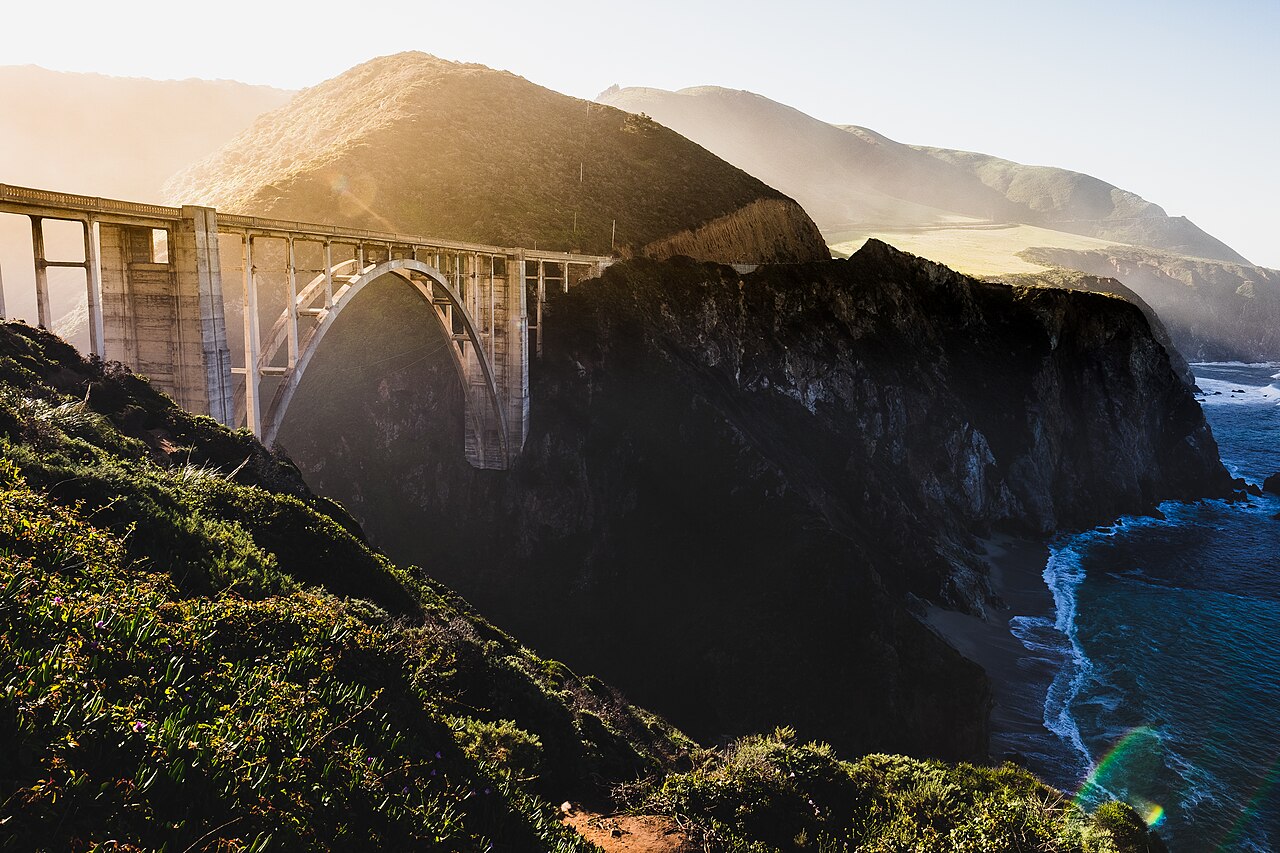
Bixby Bridge, also known as Bixby Creek Bridge, on the Big Sur coast of California, is one of the most photographed bridges in California due to its aesthetic design, "graceful architecture and magnificent setting". It is a reinforced concrete open-spandrel arch bridge. The bridge is 120 miles (190 km) south of San Francisco and 13 miles (21 km) south of Carmel in Monterey County on State Route 1.
Before the opening of the bridge in 1932, residents of the Big Sur area were virtually cut off during winter due to blockages on the often impassable Old Coast Road, which led 11 miles (18 km) inland. The bridge was built under budget for $199,861 (equivalent to $3.51 million in 2022 dollars) and, at 360 feet (110 m), was the longest concrete arch span in the California State Highway System. When it was completed, it was the highest single-span arch bridge in the world,: 45 and it remains one of the tallest.
The land north and south of the bridge was privately owned until 1988 and 2001. A logging company obtained approval to harvest redwood on the former Bixby Ranch to the north in 1986, and in 2000 a developer obtained approval to subdivide the former Brazil Ranch to the south. Local residents and conservationists fought their plans, and both pieces of land were eventually acquired by local and federal government agencies. A $20 million seismic retrofit was completed in 1996, although its 24-foot (7.3 m) width does not meet modern standards requiring bridges to be 32 feet (9.8 m) wide.
The land near the bridge was historically occupied by the native Esselen people who visited the coast seasonally to harvest shellfish and to fish offshore. When the Spanish established the California mission system, only a very few were not baptized and conscripted, and they soon left the mountains to work on the nearby ranches.[1]: 114 Governor Juan Alvarado granted the land from present day Carmel south to Palo Colorado Canyon, two miles north of Bixby Creek, to Marcelino Escobar in 1839 as part of the Rancho San Jose y Sur Chiquito. The land was later acquired by Alvarado's brother-in-law José Castro. Castro noted the existence of on a Native American trail from Monterey to Palo Colorado Canyon in 1853, when he filed a map of his grant.[2][3]
Originally Mill CreekBixby Creek is named after pioneering Yankee businessman Charles Henry Bixby. Originally from Livingston County, New York, he arrived in California in 1852 and remained for five years. He returned east before coming back to California. After some success raising cattle in Sonoma County, he obtained a patent on April 10, 1889 for 160 acres (65 ha) south of Bixby Creek,[4] and later bought additional tracts of land on the north side of the creek, between it and Palo Colorado Canyon.
Bixby built a sawmill with a capacity of twelve thousand feet of lumber per day on the creek, which was then known as Mill Creek. He harvested timber and turned it into shakes, shingles, railroad ties, and trench posts. He also harvested the bark of the tanbark oak, which was used for tanning cow hides.[5] Bixby discovered lime deposits on Long Ridge above Mill Creek. He had kilns built and used mules to haul the lime to the coast on wooden sleds.[6] The creek and canyon were renamed in his honor when the bridge was completed in November 1932.[7]
Bixby Landing
It was impossible to build a wharf from the cliffs that dropped into the ocean. To transport the tanbark and lime to Monterey and San Francisco, Bixby built a doghole port consisting of a hoist and chute that could be used to ferry goods to and from ships anchored slightly offshore.[6][8] The powdered lime was packed into barrels that were then attached to cable strung from the coastal cliff. The cargo was hoisted in slings from the landing along a cable winched about 50 yards out into the Pacific Ocean, where it was loaded aboard coastal schooners. The schooners were moored to deadeyes embedded in rocks of the adjacent shore.[9] He sold the fired lime for use in cement, mortar, and other building materials.[10]
Coast road extended southBixby tried to persuade the county to build a road to Bixby Creek, but they refused, replying that "no one would want to live there." In 1870, Bixby and his father hired men to improve the track and constructed the first wagon road including 23 bridges from the Carmel Mission to Bixby Creek.[11] Near Malpaso Creek, the creek has very steep side slopes and the crossing was a ford only 10 feet (3.0 m) above sea level until the Malpaso Creek Bridge was built in 1935 as part the Big Sur Coast Highway.
Sometime later Bixby partnered with William B. Post and extended what became known as the Old Coast Road south to his ranch. At Bixby Creek, the road was necessarily built 11 miles (18 km) inland to circumvent the deep canyon. It also went inland to circumvent the Little Sur River. It then led to the Post Ranch on the Rancho El Sur near present-day Andrew Molera State Park.[8][3]: 4–2 The 30-mile (48 km) trip from Carmel could take three days by wagon or stagecoach.[12]: 24 The single-lane road was closed in winter when it became impassable. Coast residents received supplies via a schooner from Monterey and San Francisco that off-loaded supplies that could not be transported overland near Big Sur once a year.[3]: 4–4
Sold to lime companyIn 1906, after he exhausted the supply of commercial timber, Bixby sold the land to the Monterey Lime Company. Lime was in great demand to help re-build San Francisco following the 1906 earthquake. The company built lime kilns 3 miles (4.8 km) up Bixby Canyon from the coast and mined the high grade limestone located in the area. To feed the limekiln fires, they cut much of the old growth redwood in the canyon. They built a 3 miles (4.8 km) aerial tram to haul the barrels of limestone from Long Ridge to Bixby Landing. A small group of homes grew up around the original Bixby Homestead. The kilns operated for four years until 1911 when a log jam during winter rains caused a flood in the canyon.[13] The tram was used for a while longer to off and on-load supplies for the community from schooners.[14]


. - CC BY 2.5")


Add new comment