Arquipélago das Berlengas
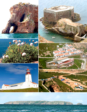
( Berlengas )

The Berlengas are a Portuguese archipelago consisting of small Atlantic islands 10 to 17 kilometres (6.2–10.6 miles) off the coast of Peniche, Portugal, in the Oeste region. These islands were traditionally known to British mariners as "the Burlings". The only inhabited island is its largest island, Berlenga Grande, although there is currently no permanent habitation in the archipelago. The other islands are grouped into two groups of islets, the Estelas Islets and the Farilhões-Forcados Islets.

 The historic penal colony: the Fort of São João Baptista das Berlengas The fishermen houses in the Berlenga Grande Island are the only dwellings in the archipelago.

Human occupation on Berlenga Grande dates back to antiquity: the islands are referred to in Ptolemy's Geography as Λονδοβρίς (Londobris).[1] Much later it was referred to as the island of Saturno by Roman geographers, and was visited successively by Muslims, Vikings and privateers.

The islands are thought to be a former sacred place adopted by the Phoenicians in the first millennium BC where the cult of Baal–Melqart was celebrated.[2]

In 1513, with the support of Queen Eleanor of Viseu, monks from the Order of São Jerónimo established a settlement on the island to offer assistance to navigation and victims of frequent shipwrecks. The monastery founded there, the Monastery of the Misericórdia da Berlenga, remained until the 16th century, when disease, lack of supplies and poor communication (due to constant inclement weather) forced the monks to abandon their service on the island.

After the Portuguese Restoration War, during the reign of King John IV, the council of war determined that the demolition of the monastery ruins and the use of their rocks to build a coastal defense would help protect the coastal settlements; the Fort of São João Baptista das Berlengas was constructed from the remnants of the monastery ruins. By 1655, it had already, during its construction, resisted an assault by three Barbary Coast pirates.[clarification needed]

The island's lighthouse (dubbed Duke of Braganza by locals) was constructed in 1841.[3] In the 20th century a solar panel was installed in the lighthouse's 29-metre (95 ft) column, providing a 50-kilometre (31 mi) field of vision.

The International Coordinating Council of UNESCO's Man and the Biosphere Programme (MAB), meeting in Dresden (Germany) from 28 June to 1 July, while adding 18 new sites, included the Berlengas to the World Network of Biosphere Reserves (WNBR): in a statement on 30 June 2011, the list of classified reserves were presented.[4]

^ The Geography of Claudius Ptolemy ^ "História e Cultura". ICNF. Archived from the original on 15 January 2023. Retrieved 5 November 2020. ^ "Dissertação de Mestrado em Cidadania Ambiental e Participação" (PDF). António João Farinha Ribeiro dos Santos. Retrieved October 6, 2020. ^ UNESCO, ed. (30 June 2011). "18 new Biosphere Reserves added to UNESCO's Man and the Biosphere (MAB) Programme". Paris, France: UNESCO/Natural Sciences UNESCOPRESS. Retrieved 30 June 2011.
Photographies by:
Nicotappero - CC BY-SA 4.0
Statistics: Position
2097
Statistics: Rank
64323

Add new comment

Esta pregunta es para comprobar si usted es un visitante humano y prevenir envíos de spam automatizado.

Security
653782194Click/tap this sequence: 4576

Google street view

Where can you sleep near Berlengas ?

Booking.com
489.840 visits in total, 9.196 Points of interest, 404 Destinations, 1 visits today.